File:Satellite image map of Mayak.jpg
Aller à la navigation
Aller à la recherche

Taille de cet aperçu : 800 × 509 pixels. Autres résolutions : 320 × 204 pixels | 640 × 408 pixels | 1 024 × 652 pixels | 1 448 × 922 pixels.
Fichier d’origine (1 448 × 922 pixels, taille du fichier : 290 kio, type MIME : image/jpeg)
Légendes
Légendes
Ajoutez en une ligne la description de ce que représente ce fichier
most radioactive place on Earth
| Description |
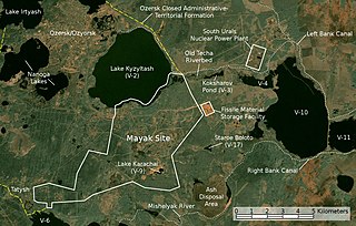
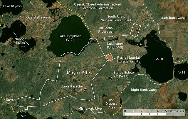
English: Satellite image/map of the Mayak nuclear facility, the closed town of Ozyorsk/Ozersk (Chelyabinsk-65), different lakes and reservoirs, and the South Urals nuclear power plant.
Based on a screenshot from NASA World Wind (Landsat Global Mosaic visual layer), color corrected.
Deutsch: Satellitenfoto/Karte der kerntechnischen Anlage Majak, der geschlossenen Stadt Osjorsk (Tscheljabinsk-65), verschiedenen Seen und Reservoirs sowie dem Kernkraftwerk Süd-Ural.
Basierend auf einem Screenshot aus NASA World Wind (Landsat Global Mosaic visual layer), farbkorrigiert. |
|||||
| Date | ||||||
| Source | NASA World Wind screenshot (Landsat Global Mosaic visual layer) | |||||
| Auteur | NASA, Jan Rieke (color correction, borders and labels) | |||||
| Autorisation (Réutilisation de ce fichier) |
|
|||||
| Autres versions | File:Majak Satellitenkarte.jpg |

| Cette image a été retouchée, ce qui signifie qu'elle a été modifiée par ordinateur et est différente de l'image d'origine. Liste des modifications : color correction, labeling. Modifications effectuées par JanRieke.
|
| Lieu de la prise de vue | | Voir cet endroit et d’autres images sur : OpenStreetMap |
|---|
Credit appreciated when reusing this image.
Sources[modifier]
Primary Sources[modifier]
- Igor Kudrik, Aleksandr Nikitin, Charles Digges, Nils Bøhmer, Vladislav Larin, Vladimir Kuznetsov: The Russian Nuclear Industry – The Need for Reform. Bellona Report Volume 4:2004. Bellona Foundation, pp. 47–69, November 1, 2004
- Map of the system of dams and drainage channels at Mayak., in: AMAP Assessment Report: Arctic Pollution Issues, Arctic Monitoring & Assessment Programme, Working Group of the Arctic Council, 1998
- Dmitriy Burmistrov, Mira Kossenko, Richard Wilson: Radioactive Contamination of the Techa River and its Effects. copie d'archive at the Wayback Machine Technology, Vol. 7, pp. 553-575, 2000
Secondary Sources[modifier]
Location of V-6[modifier]
- B. Gusakov, A. Demin, M. Zawadzki, V. Kalinkin, A. Kirsanov, N. Shafrova: Решение экологических проблем Теченского каскада водоемов на ПО "Маяк"., December 19, 2006
Ash Disposal Area[modifier]
- A. R. Hutter: Radioactive contamination distribution in the bottom sediments and water of the Mishelyak River[lien mort], Journal of Radioanalytical and Nuclear Chemistry, 2001
- O. Aleksandrova: Natural remediation of surface water systems used as deposits of nuclear industry waste by humic substances, Dissertation, University of Osnabrück, 2009
Historique du fichier
Cliquer sur une date et heure pour voir le fichier tel qu'il était à ce moment-là.
| Date et heure | Vignette | Dimensions | Utilisateur | Commentaire | |
|---|---|---|---|---|---|
| actuel | 28 novembre 2010 à 03:45 | | 1 448 × 922 (290 kio) | JanRieke (d | contributions) | included courses of rivers, yellow color for closed city borders, slightly reduced brightness, minor other changes |
| 14 mai 2010 à 22:12 |  | 1 448 × 922 (275 kio) | JanRieke (d | contributions) | label for Mishelyak River, removed name of V-4 due to contradictory sources | |
| 9 mai 2010 à 03:00 |  | 1 448 × 922 (275 kio) | JanRieke (d | contributions) | Minor improvements: alternative spelling of Ozersk "Ozyorsk", incr. font size for Mayak, ash disposal area, transparency for scale | |
| 30 avril 2010 à 23:44 |  | 1 448 × 922 (272 kio) | JanRieke (d | contributions) | {{Information |Description={{en|1=Satellite image/map of the Mayak nuclear facility, the closed town of Ozersk (Chelyabinsk-65), different lakes and reservoirs, and the South Urals nuclear power plant. Based on a screenshot from NASA World Wind (Landsat G |
Vous ne pouvez pas remplacer ce fichier.
Utilisations locales du fichier
Les 2 pages suivantes utilisent ce fichier :
Utilisations du fichier sur d’autres wikis
Les autres wikis suivants utilisent ce fichier :
- Utilisation sur ar.wikipedia.org
- Utilisation sur cs.wikipedia.org
- Utilisation sur da.wikipedia.org
- Utilisation sur de.wikipedia.org
- Utilisation sur en.wikipedia.org
- Utilisation sur eu.wikipedia.org
- Utilisation sur fa.wikipedia.org
- Utilisation sur fi.wikipedia.org
- Utilisation sur fr.wikipedia.org
- Utilisation sur he.wikipedia.org
- Utilisation sur hr.wikipedia.org
- Utilisation sur hu.wikipedia.org
- Utilisation sur ig.wikipedia.org
- Utilisation sur it.wikipedia.org
- Utilisation sur ja.wikipedia.org
- Utilisation sur ko.wikipedia.org
- Utilisation sur mk.wikipedia.org
- Utilisation sur nl.wikipedia.org
- Utilisation sur nn.wikipedia.org
- Utilisation sur pl.wikipedia.org
- Utilisation sur pt.wikipedia.org
- Utilisation sur ru.wikipedia.org
- Utilisation sur simple.wikipedia.org
- Utilisation sur sk.wikipedia.org
- Utilisation sur sr.wikipedia.org
- Utilisation sur sv.wikipedia.org
- Utilisation sur vi.wikipedia.org
- Utilisation sur zh.wikipedia.org