File:Satsunan-Islands-Kagoshima-Japan.png
跳转到导航
跳转到搜索

本预览的尺寸:391 × 599像素。 其他分辨率:157 × 240像素 | 313 × 480像素 | 501 × 768像素 | 668 × 1,024像素 | 1,622 × 2,484像素。
原始文件 (1,622 × 2,484像素,文件大小:1.24 MB,MIME类型:image/png)
说明
说明
添加一行文字以描述该文件所表现的内容
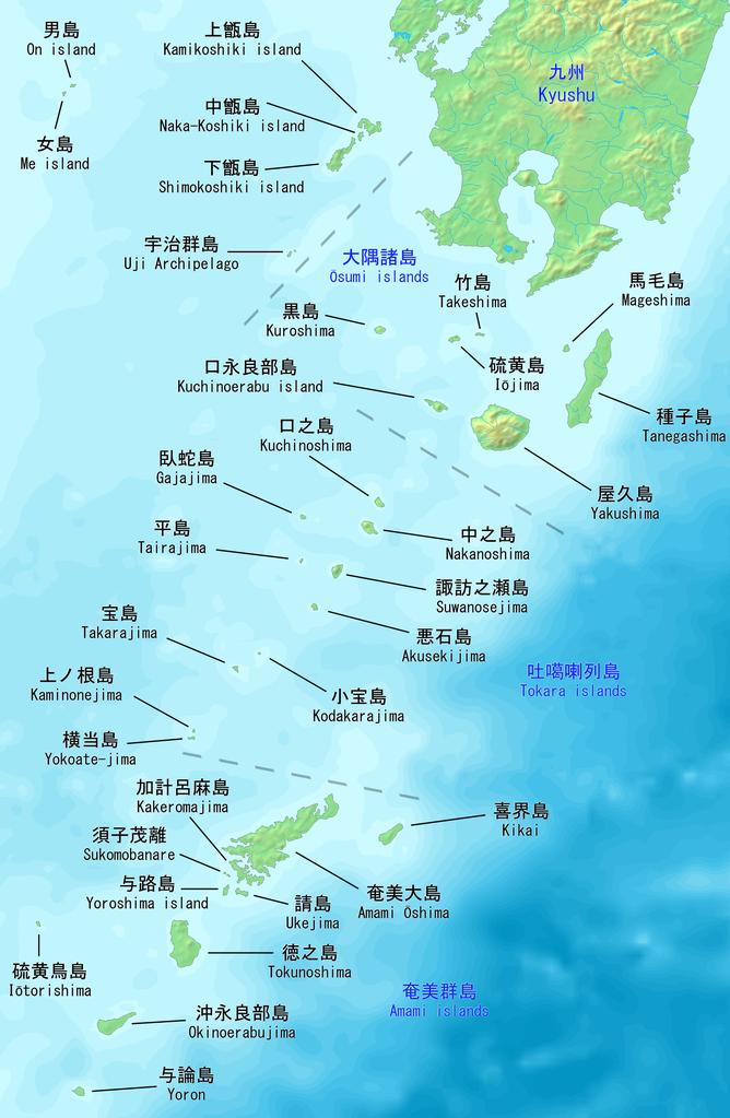
Map of the Satsunan Islands of Kagoshima, Japan.
摘要[编辑]
| 描述 |
English: Map of the Satsunan Islands of Kagoshima, Japan. Made with DEMIS World Map Server.
日本語: 薩南諸島の地図。 鹿児島、日本。 |
||||
| 日期 | |||||
| 来源 | https://www.demis.nl/products/web-map-server/examples | ||||
| 作者 |
DEMIS World Map Server, Artanisen
|
许可协议[编辑]
| 本作品采用知识共享CC0 1.0 通用公有领域贡献许可协议授权。 | |
| 采用本宣告发表本作品的人,已在法律允许的范围内,通过在全世界放弃其对本作品拥有的著作权法规定的所有权利(包括所有相关权利),将本作品贡献至公有领域。您可以复制、修改、传播和表演本作品,将其用于商业目的,无需要求授权。
|
文件历史
点击某个日期/时间查看对应时刻的文件。
| 日期/时间 | 缩略图 | 大小 | 用户 | 备注 | |
|---|---|---|---|---|---|
| 当前 | 2019年10月22日 (二) 20:04 | | 1,622 × 2,484(1.24 MB) | Artanisen(留言 | 贡献) | Added Sukomobanare island (須子茂離島). |
| 2019年10月21日 (一) 05:09 |  | 1,622 × 2,484(1.22 MB) | Artanisen(留言 | 贡献) | Added info about the Tokara islands, Amami islands and Osumi islands. | |
| 2019年10月20日 (日) 20:23 |  | 1,622 × 2,484(1.15 MB) | Artanisen(留言 | 贡献) | User created page with UploadWizard |
您不可以覆盖此文件。
文件用途
以下4个页面使用本文件:
全域文件用途
以下其他wiki使用此文件:
- ar.wikipedia.org上的用途
- az.wikipedia.org上的用途
- bg.wikipedia.org上的用途
- bn.wikipedia.org上的用途
- ca.wikipedia.org上的用途
- ceb.wikipedia.org上的用途
- cs.wikipedia.org上的用途
- de.wikipedia.org上的用途
- en.wikipedia.org上的用途
- es.wikipedia.org上的用途
- fa.wikipedia.org上的用途
- fr.wikipedia.org上的用途
- gl.wikipedia.org上的用途
- id.wikipedia.org上的用途
- it.wikipedia.org上的用途
- ja.wikipedia.org上的用途
查看本文件的更多全域用途。