File:Sayer Accurate Map of North America 1775 UTA (top).jpg
Jump to navigation
Jump to search
Size of this preview: 800 × 358 pixels. Other resolutions: 320 × 143 pixels | 640 × 286 pixels | 1,431 × 640 pixels.
Original file (1,431 × 640 pixels, file size: 804 KB, MIME type: image/jpeg)
Captions
Captions
Add a one-line explanation of what this file represents
Summary[edit]
| Title |
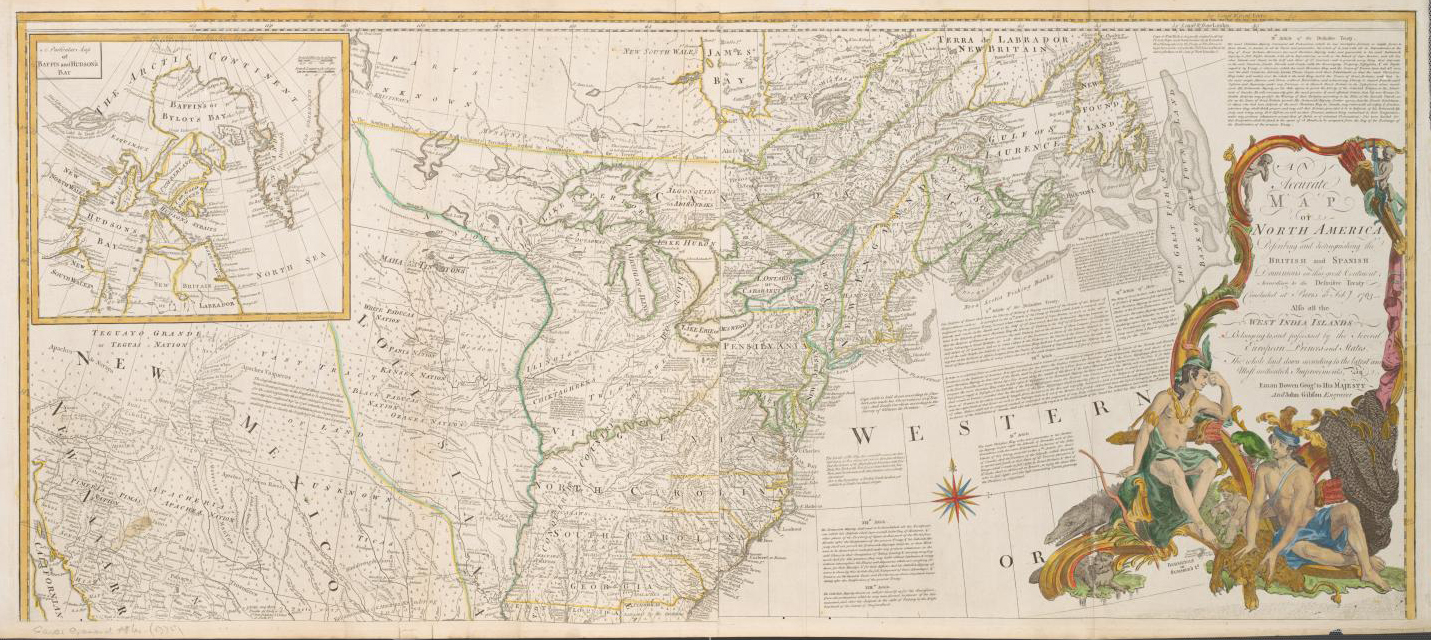
English: An Accurate Map of North America Describing and distinguishing the British and Spanish Dominions of this great Continent According to the Definitive Treaty Concluded at Paris 10th Feby. 1763... |
|||||||||||||||||||||||||||||||||||||||||||||||||||||||||||||||||
| Date | ||||||||||||||||||||||||||||||||||||||||||||||||||||||||||||||||||
| Source | UTA Libraries Cartographic Connections: map / text | |||||||||||||||||||||||||||||||||||||||||||||||||||||||||||||||||
| Creator |
|
|||||||||||||||||||||||||||||||||||||||||||||||||||||||||||||||||
| Credit line |
English: UTA Libraries Special Collections, Gift of Virginia Garrett |
|||||||||||||||||||||||||||||||||||||||||||||||||||||||||||||||||
| Geotemporal data | ||||||||||||||||||||||||||||||||||||||||||||||||||||||||||||||||||
| Map location | North America | |||||||||||||||||||||||||||||||||||||||||||||||||||||||||||||||||
| Georeferencing | If inappropriate please set warp_status = skip to hide. | |||||||||||||||||||||||||||||||||||||||||||||||||||||||||||||||||
| Bibliographic data | ||||||||||||||||||||||||||||||||||||||||||||||||||||||||||||||||||
| Place of publication | London | |||||||||||||||||||||||||||||||||||||||||||||||||||||||||||||||||
| Printed by |
|
|||||||||||||||||||||||||||||||||||||||||||||||||||||||||||||||||
| Archival data | ||||||||||||||||||||||||||||||||||||||||||||||||||||||||||||||||||
| Collection |
|
|||||||||||||||||||||||||||||||||||||||||||||||||||||||||||||||||
| Dimensions | height: 54 cm (21.2 in); width: 123 cm (48.4 in) | |||||||||||||||||||||||||||||||||||||||||||||||||||||||||||||||||
| Medium |
colored engraving colored etching print |
|||||||||||||||||||||||||||||||||||||||||||||||||||||||||||||||||
| Other versions |
|
|||||||||||||||||||||||||||||||||||||||||||||||||||||||||||||||||
_the_sayer_family_of_richmond_(cropped).jpg)

.jpg)
.jpg&action=edit§ion=1)
Licensing[edit]
.jpg&action=edit§ion=2)

|
This file was provided to Wikimedia Commons by the University of Texas at Arlington Libraries as part of a cooperation project. The University of Texas at Arlington Libraries is part of the University of Texas at Arlington, a public research university located in Arlington, Texas.
|
|
The author died in 1794, so this work is in the public domain in its country of origin and other countries and areas where the copyright term is the author's life plus 100 years or fewer. This work is in the public domain in the United States because it was published (or registered with the U.S. Copyright Office) before January 1, 1929. | |
| This file has been identified as being free of known restrictions under copyright law, including all related and neighboring rights. | |
File history
Click on a date/time to view the file as it appeared at that time.
| Date/Time | Thumbnail | Dimensions | User | Comment | |
|---|---|---|---|---|---|
| current | 15:44, 18 February 2022 | | 1,431 × 640 (804 KB) | Michael Barera (talk | contribs) | == {{int:filedesc}} == {{Map |title = {{en|'''''An Accurate Map of North America Describing and distinguishing the British and Spanish Dominions of this great Continent According to the Definitive Treaty Concluded at Paris 10th Feby. 1763...'''''}} |description = |legend = |author = {{Creator:Robert Sayer}} {{after|{{Creator:Emanuel Bowen}}}} {{after|{{Creator:John Gibson}}}} |date = 1775 |source = UTA Libraries ''Cartogr... |
You cannot overwrite this file.
File usage on Commons
The following 2 pages use this file:
File usage on other wikis
The following other wikis use this file:
- Usage on de.wikipedia.org
- Usage on en.wikipedia.org
- Usage on id.wikipedia.org
- Usage on it.wikipedia.org
- Usage on ko.wikipedia.org
- Usage on ru.wikipedia.org
.jpg&oldid=630797981)