File:Scg01.png
Zur Navigation springen
Zur Suche springen

Greßi vu däre Vorschau: 409 × 600 Pixel. Wyteri Ufflösige: 163 × 240 Pixel | 327 × 480 Pixel | 818 × 1.200 Pixel.
Originaldatei (818 × 1.200 Pixel, Dateigrößi: 56 KB, MIME-Typ: image/png)
Bildtexte
Kurzbeschreibungen
Ergänze eine einzeilige Erklärung, was diese Datei darstellt.
Bschryybig[ändere]
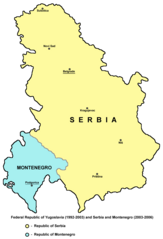
- English: Federal Republic of Yugoslavia (1992-2003) and Serbia and Montenegro (2003-2006).
- Serbian: Savezna Republika Jugoslavija (1992-2003) i Srbija i Crna Gora (2003-2006).
References[ändere]
- Slobodan Radovanović, Geografski atlas, Magic Map, Smederevska Palanka, 2001.
- Školski geografski atlas, Intersistem Kartografija, Beograd, 2004.
- Miodrag Milošević, Geografija za 8. razred osnovne škole, Beograd, 1994.
- Istorijski atlas, Zavod za kartografiju "Geokarta", Beograd, 1999.
- Denis Šehić - Demir Šehić, Istorijski atlas sveta, Beograd, 2007.
- http://cartage.org.lb/en/themes/GeogHist/geography/cartes/mapcountries/S/photoS/serbia.gif
- http://www.aboutromania.com/SerbiaAndMontenegroMap.gif
- http://cache.virtualtourist.com/1452908-Map_of_Serbia_and_Montenegro-Former_Republic_of_Serbia_and_Montenegro.jpg
- http://www.lib.utexas.edu/maps/europe/serbia.jpg
Source and licence[ändere]
Self-made map by PANONIAN
| Des Wärch isch vu syym Urheber PANONIAN as gmeinfrej vereffentligt wore. Des giltet wältwyt. In mänke Staate chennt des rächtli nit megli syy. Wänn des imfall eso isch: |

|
This map has been uploaded by Electionworld from en.wikipedia.org to enable the |
Dateiversione
Klick uf e Zytpunkt zu aazeige, wie s dert usgsäh het.
| Version vom | Vorschaubild | Mäß | Benutzer | Kommentar | |
|---|---|---|---|---|---|
| aktuell | 10:27, 25. Aug. 2012 | | 818 × 1.200 (56 KB) | PANONIAN (Diskussion | Byträg) | minor correction |
| 10:12, 25. Aug. 2012 |  | 818 × 1.200 (56 KB) | PANONIAN (Diskussion | Byträg) | minor correction | |
| 12:27, 14. Dez. 2009 |  | 818 × 1.200 (56 KB) | PANONIAN (Diskussion | Byträg) | Reverted to version as of 11:32, 14 December 2009 - fixing thumbnail problem | |
| 12:25, 14. Dez. 2009 |  | 500 × 669 (95 KB) | PANONIAN (Diskussion | Byträg) | Reverted to version as of 21:41, 21 December 2006 - fixing thumbnail problem | |
| 11:32, 14. Dez. 2009 |  | 818 × 1.200 (56 KB) | PANONIAN (Diskussion | Byträg) | improved version | |
| 21:41, 21. Dez. 2006 |  | 500 × 669 (95 KB) | Electionworld (Diskussion | Byträg) | {{ew|en|PANONIAN}} Self-made map by PANONIAN {{PD-user|PANONIAN}} Category:Maps of Serbia Category:Maps of Montenegro |
Du chasch die Datei nit iberschryybe.
Verwändig vu dr Datei
Die 22 Syte bruuche die Datei:
- Atlas of Kosovo
- Atlas of Montenegro
- Atlas of Serbia
- Atlas of Yugoslavia
- File:República Federal da Iugoslávia (1992-2003) location map-pt.svg
- Category:1993 in Serbia
- Category:1994 in Serbia
- Category:1995 in Serbia
- Category:1996 in Serbia
- Category:1997 in Serbia
- Category:1998 in Serbia
- Category:1999 in Montenegro
- Category:1999 in Serbia
- Category:2000 in Serbia
- Category:2001 in Serbia
- Category:2002 in Montenegro
- Category:2002 in Serbia
- Category:2003 in Montenegro
- Category:2003 in Serbia
- Category:2004 in Montenegro
- Category:2004 in Serbia
- Category:2005 in Montenegro
_location_map-pt.svg)
Wältwyti Dateinutzig
Die andere Wikis bruche die Datei:
- Gebruch uf als.wikipedia.org
- Gebruch uf an.wikipedia.org
- Gebruch uf ar.wikipedia.org
- Gebruch uf ast.wikipedia.org
- Gebruch uf az.wikipedia.org
- Gebruch uf be-tarask.wikipedia.org
- Gebruch uf be.wikipedia.org
- Gebruch uf bg.wikipedia.org
- Gebruch uf bs.wikipedia.org
- Gebruch uf ca.wikipedia.org
- Gebruch uf cs.wikipedia.org
- Gebruch uf cy.wikipedia.org
- Gebruch uf da.wikipedia.org
- Gebruch uf el.wikipedia.org
- Gebruch uf en.wikipedia.org
- Gebruch uf es.wikipedia.org
- Gebruch uf eu.wikipedia.org
- Gebruch uf fi.wikipedia.org
- Gebruch uf fr.wikipedia.org
- Gebruch uf fy.wikipedia.org
- Gebruch uf gl.wikipedia.org
- Gebruch uf hi.wikipedia.org
- Gebruch uf hr.wikipedia.org
- Gebruch uf id.wikipedia.org
- Gebruch uf io.wikipedia.org
- Gebruch uf is.wikipedia.org
- Gebruch uf it.wikipedia.org
- Gebruch uf ja.wikipedia.org
- Gebruch uf kk.wikipedia.org
- Gebruch uf ko.wikipedia.org
- Gebruch uf kw.wikipedia.org
- Gebruch uf li.wikipedia.org
- Gebruch uf lt.wikipedia.org
Wältwyti Verwändig vu däre Datei aaluege.