File:Schema-Karte KZ-Außenlager Kaufering I - Landsberg sub camp of Dachau.png
Jump to navigation
Jump to search

Size of this preview: 800 × 469 pixels. Other resolutions: 320 × 188 pixels | 640 × 375 pixels | 1,024 × 601 pixels | 1,280 × 751 pixels | 2,560 × 1,501 pixels | 3,787 × 2,221 pixels.
Original file (3,787 × 2,221 pixels, file size: 4.97 MB, MIME type: image/png)
Captions
Captions
Add a one-line explanation of what this file represents
Summary
[edit]
| Description |
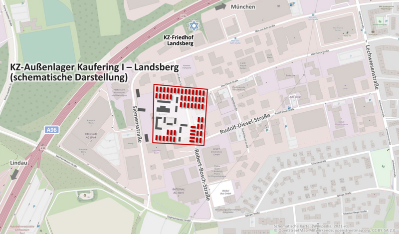
Deutsch: Schema-Karte KZ-Außenlager Kaufering I - Landsberg sub camp of Dachau |
| Date | |
| Source | https://www.openstreetmap.org/#map=17/48.06146/10.85525 |
| Author |
© OpenStreetMap-Mitwirkende, openstreetmap.org, CC BY-SA 2.0. Ergänzt mit schematischer Darstellung des KZ-Außenlager Kaufering I – Landsberg |
Licensing
[edit]
This file is licensed under the Creative Commons Attribution-Share Alike 2.0 Generic license.
- You are free:
- to share – to copy, distribute and transmit the work
- to remix – to adapt the work
- Under the following conditions:
- attribution – You must give appropriate credit, provide a link to the license, and indicate if changes were made. You may do so in any reasonable manner, but not in any way that suggests the licensor endorses you or your use.
- share alike – If you remix, transform, or build upon the material, you must distribute your contributions under the same or compatible license as the original.
File history
Click on a date/time to view the file as it appeared at that time.
| Date/Time | Thumbnail | Dimensions | User | Comment | |
|---|---|---|---|---|---|
| current | 20:05, 28 September 2021 | | 3,787 × 2,221 (4.97 MB) | Treck08 (talk | contribs) | Uploaded a work by © OpenStreetMap-Mitwirkende, openstreetmap.org, CC BY-SA 2.0. Ergänzt mit schematischer Darstellung des KZ-Außenlager Kaufering I – Landsberg from https://www.openstreetmap.org/#map=17/48.06146/10.85525 with UploadWizard |
You cannot overwrite this file.
File usage on Commons
There are no pages that use this file.
File usage on other wikis
The following other wikis use this file:
- Usage on de.wikipedia.org