File:Schieder-Schwalenberg - Schwalenberger Wald - Map.png
Jump to navigation
Jump to search

Size of this preview: 682 × 600 pixels. Other resolutions: 273 × 240 pixels | 546 × 480 pixels | 873 × 768 pixels | 1,164 × 1,024 pixels | 1,338 × 1,177 pixels.
Original file (1,338 × 1,177 pixels, file size: 892 KB, MIME type: image/png)
Captions
Captions
Add a one-line explanation of what this file represents
Summary
[edit]
Summary
| Description |
|
| Date | |
| Source |
Own work, based on: |
| Author | Hagar66 |
| Permission (Reusing this file) |
Licensed under the GFDL by author |
| Camera location | | View this and other nearby images on: OpenStreetMap |
|---|
- Note
- Homemade maps cannot be 100% accurate. This is especially true for topographical data that is hard to incorporate 100% correctly in such maps. You are free to use the map as a starting point for your new improved versions.
Licensing
[edit]
This file is licensed under the Creative Commons Attribution-Share Alike 3.0 Unported license.
- You are free:
- to share – to copy, distribute and transmit the work
- to remix – to adapt the work
- Under the following conditions:
- attribution – You must give appropriate credit, provide a link to the license, and indicate if changes were made. You may do so in any reasonable manner, but not in any way that suggests the licensor endorses you or your use.
- share alike – If you remix, transform, or build upon the material, you must distribute your contributions under the same or compatible license as the original.
File history
Click on a date/time to view the file as it appeared at that time.
| Date/Time | Thumbnail | Dimensions | User | Comment | |
|---|---|---|---|---|---|
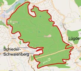
| current | 10:02, 12 October 2009 | | 1,338 × 1,177 (892 KB) | Hagar66 (talk | contribs) | == Summary == {{int:filedesc}} {{Information |Description= {{en|''Schieder-Schwalenberg - Nature reserve Schwalenberger Wald - overview map''}} {{de|''Schieder-Schwalenberg - Naturschutzgebiet Sc |
You cannot overwrite this file.
File usage on Commons
The following page uses this file:
File usage on other wikis
The following other wikis use this file:
- Usage on de.wikipedia.org
- Usage on www.wikidata.org