File:Schoppernau Mitteldorf 43.JPG
Original file (5,989 × 4,841 pixels, file size: 19.49 MB, MIME type: image/jpeg)
Captions
Captions
DescriptionSchoppernau Mitteldorf 43.JPG |
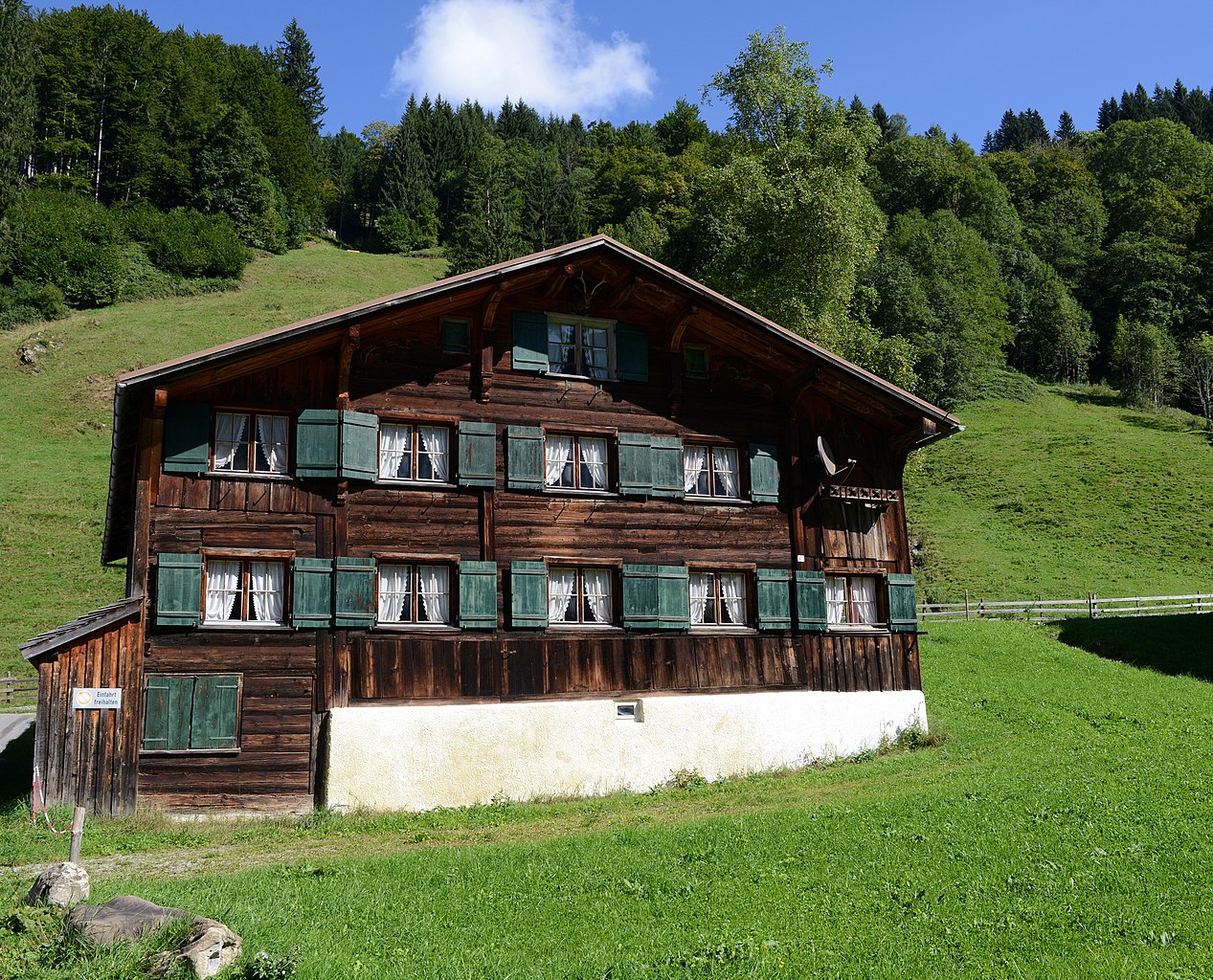
Deutsch: aus dem DEHIO Vorarlberg 1983: Schoppernau, BAUERNHÖFE: Großteils spätes 18. und 1.Hälfte 19. Jhs. beziehungsweise im 19. Jh. ausgbaut, die Wohnteile verschindelte Blockbauten mit 4- bis 6achsigen Giebelfronten und traufseitig offenem Schopf. Ensembles bilden im Ortskern Nr. 12-19 (Nr.14 mit breiter 7achsiger Giebelfront, Ende des 19 Jhs. ausgebaut) und Nr.25,26,28; am östlichen Dorfrand Nr. 62-65 und Nr.67. Nr.43: Einhof, Wohnteil bezeichnet 1786, Blockbau auf Kellersockel, zum Teil mit Bretterschirm, traufseitig offener Schopf, Pfettenunterzüge, Ochsenblutanstrich und Rokokomalerei.
|
||
Date | |||
Source | Own work | ||
Author |
|
||
Permission (Reusing this file) |
I, the copyright holder of this work, hereby publish it under the following license: ![]() ![]() ![]() This file is licensed under the Creative Commons Attribution-Share Alike 3.0 Austria license.
![]() |
Camera location | 47° 18′ 38.89″ N, 10° 01′ 13.79″ E ![]() | View this and other nearby images on: OpenStreetMap | ![]() |
---|
Object location | 47° 18′ 40.08″ N, 10° 01′ 14.33″ E ![]() | View this and other nearby images on: OpenStreetMap | ![]() |
---|
Quelle: Dehio Vorarlberg
![]() |
This image was uploaded as part of Wiki Loves Monuments 2013.
Afrikaans ∙ Alemannisch ∙ azərbaycanca ∙ Bahasa Indonesia ∙ Bahasa Melayu ∙ Bikol Central ∙ bosanski ∙ brezhoneg ∙ català ∙ čeština ∙ Cymraeg ∙ dansk ∙ davvisámegiella ∙ Deutsch ∙ eesti ∙ English ∙ español ∙ Esperanto ∙ euskara ∙ français ∙ Frysk ∙ Gaeilge ∙ galego ∙ hrvatski ∙ Ido ∙ italiano ∙ latviešu ∙ Lëtzebuergesch ∙ Malagasy ∙ magyar ∙ Malti ∙ Nederlands ∙ norsk ∙ norsk nynorsk ∙ norsk bokmål ∙ polski ∙ português ∙ português do Brasil ∙ română ∙ shqip ∙ sicilianu ∙ slovenčina ∙ slovenščina ∙ suomi ∙ svenska ∙ Tagalog ∙ Türkçe ∙ Yorùbá ∙ Zazaki ∙ Ελληνικά ∙ беларуская ∙ беларуская (тарашкевіца) ∙ български ∙ кыргызча ∙ македонски ∙ русский ∙ српски / srpski ∙ українська ∙ ქართული ∙ հայերեն ∙ नेपाली ∙ हिन्दी ∙ বাংলা ∙ മലയാളം ∙ ไทย ∙ 한국어 ∙ +/− |
![]() |
File history
Click on a date/time to view the file as it appeared at that time.
Date/Time | Thumbnail | Dimensions | User | Comment | |
---|---|---|---|---|---|
current | 22:52, 21 September 2013 | 5,989 × 4,841 (19.49 MB) | Böhringer (talk | contribs) | {{Information |Description= {{de| '''aus dem DEHIO Vorarlberg 1983:''' Schoppernau, BAUERNHÖFE: Großteils spätes 18. und 1.Hälfte 19. Jhs. beziehungsweise im 19. Jh. ausgbaut, die Wohnteile verschindelte Blockbaute... |
You cannot overwrite this file.
File usage on Commons
The following page uses this file:
File usage on other wikis
The following other wikis use this file:
- Usage on de.wikipedia.org
- Usage on nl.wikipedia.org
- Usage on www.wikidata.org
Metadata
This file contains additional information such as Exif metadata which may have been added by the digital camera, scanner, or software program used to create or digitize it. If the file has been modified from its original state, some details such as the timestamp may not fully reflect those of the original file. The timestamp is only as accurate as the clock in the camera, and it may be completely wrong.
Camera manufacturer | NIKON CORPORATION |
---|---|
Camera model | NIKON D800E |
Author | rufre@lenz-nennig.at |
Copyright holder |
|
Exposure time | 1/320 sec (0.003125) |
F-number | f/9 |
ISO speed rating | 200 |
Date and time of data generation | 12:19, 21 September 2013 |
Lens focal length | 29 mm |
Orientation | Normal |
Software used | Capture NX 2.2.5 W |
File change date and time | 00:43, 22 September 2013 |
Y and C positioning | Centered |
Exposure Program | Normal program |
Exif version | 2.3 |
Date and time of digitizing | 12:19, 21 September 2013 |
Meaning of each component |
|
APEX exposure bias | 0 |
Maximum land aperture | 3 APEX (f/2.83) |
Metering mode | Pattern |
Light source | Unknown |
Flash | Flash did not fire, compulsory flash suppression |
DateTime subseconds | 70 |
DateTimeOriginal subseconds | 70 |
DateTimeDigitized subseconds | 70 |
Supported Flashpix version | 1 |
Color space | Uncalibrated |
Sensing method | One-chip color area sensor |
File source | Digital still camera |
Scene type | A directly photographed image |
Custom image processing | Normal process |
Exposure mode | Auto exposure |
White balance | Auto white balance |
Digital zoom ratio | 1 |
Focal length in 35 mm film | 29 mm |
Scene capture type | Standard |
Scene control | None |
Contrast | Normal |
Saturation | Normal |
Sharpness | Normal |
Subject distance range | Unknown |
GPS tag version | 2.3.0.0 |
Structured data
Items portrayed in this file
depicts
21 September 2013
47°18'38.891"N, 10°1'13.789"E
47°18'40.082"N, 10°1'14.333"E
0.003125 second
29 millimetre
200
- Cultural heritage monuments in Austria with known IDs
- Photos by Böhringer
- CC-BY-SA-3.0-AT
- Self-published work
- Images from Wiki Loves Monuments 2013
- Images from Wiki Loves Monuments 2013 in Austria
- Images from Wiki Loves Monuments missing SDC creator
- Cultural heritage monuments in Austria check done
- Austria photographs taken on 2013-09-21
- Pages with maps