File:Schwebebahn Dresden.jpg
Jump to navigation
Jump to search

Size of this preview: 800 × 600 pixels. Other resolutions: 320 × 240 pixels | 640 × 480 pixels | 1,024 × 768 pixels | 1,280 × 960 pixels | 1,600 × 1,200 pixels.
Original file (1,600 × 1,200 pixels, file size: 607 KB, MIME type: image/jpeg)
Captions
Captions
Add a one-line explanation of what this file represents
| Description |
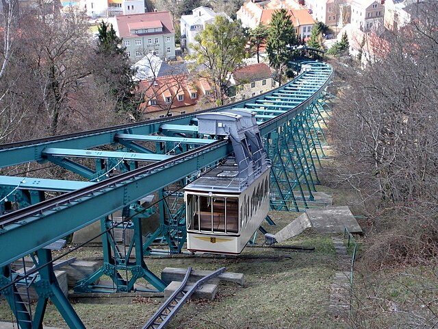
Bild: Rolf-Dresden Deutsch: Die Schwebebahn Dresden ist die älteste Hängebahn der Welt. Sie verbindet die Stadtteile Loschwitz und Oberloschwitz. Die Bahn hat eine Streckenlänge von 274 m und überwindet einen Höhenunterschied von etwa 84 m. Sie wurde am 6. Mai 1901 eröffnet. Die Schwebebahn Dresden ist trotz ihrer Kosntruktion als Schwebebahn technisch eine gewöhnliche Standseilbahn (Pendelbahn). Die Wagen sind nicht motorisiert, sondern mit einem Seil über eine Umlenkrolle in der Bergstation verbunden.
English: The Schwebebahn Dresden is the oldest suspension railway - a kind of hanging monorail - in the world (built in 1901). It is situated in Dresden, Germany, and connects the districts of Loschwitz and Oberloschwitz. The line is 274 metres long and is supported on 33 pillars.
Despite its unusual suspended format, the Dresden Schwebebahn is operated as a conventional funicular railway. The two cars are attached to each other by a cable, which runs around a drum at the top of the incline. The ascending car is pulled up the hill by the weight of the descending car, assisted if necessary by an electric drive to the drum. |
||
| Date | |||
| Source | Flickr: Schwebebahn Dresden | ||
| Author | hrs51 | ||
| Permission (Reusing this file) |
This file is licensed under the Creative Commons Attribution 2.0 Generic license.
|
| Camera location | | View this and other nearby images on: OpenStreetMap |
|---|
File history
Click on a date/time to view the file as it appeared at that time.
| Date/Time | Thumbnail | Dimensions | User | Comment | |
|---|---|---|---|---|---|
| current | 15:46, 25 December 2011 | | 1,600 × 1,200 (607 KB) | Flickr upload bot (talk | contribs) | Uploaded from http://flickr.com/photo/39028849@N06/4808482376 using Flickr upload bot |
You cannot overwrite this file.
File usage on Commons
There are no pages that use this file.
File usage on other wikis
The following other wikis use this file:
- Usage on fr.wikipedia.org