File:Second world war europe 1943-1945 map de.png
跳至導覽
跳至搜尋

預覽大小:654 × 600 像素。 其他解析度:262 × 240 像素 | 523 × 480 像素 | 837 × 768 像素 | 1,088 × 998 像素。
原始檔案 (1,088 × 998 像素,檔案大小:274 KB,MIME 類型:image/png)
說明
說明
添加單行說明來描述出檔案所代表的內容
摘要[編輯]
| 描述 |
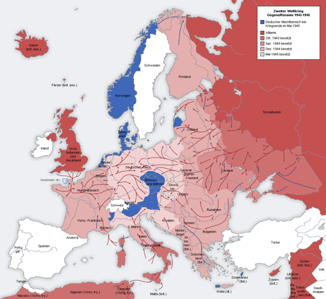
Deutsch: Zweiter Weltkrieg Europa 1943-1945 English: Second world war europe 1943-1945 in German |
| 日期 | |
| 來源 |
Deutsch: Eigene Karte, basierend auf den Karten der University of Texas Libraries English: Own map, based on the maps of the University of Texas Libraries |
| 作者 | San Jose |
| 其他版本 |
Derivative works of this file: |
授權條款[編輯]

|
已授權您依據自由軟體基金會發行的無固定段落、封面文字和封底文字GNU自由文件授權條款1.2版或任意後續版本,對本檔進行複製、傳播和/或修改。該協議的副本列在GNU自由文件授權條款中。 |
| 此檔案採用創用CC 姓名標示-相同方式分享 3.0 未在地化版本授權條款。 | ||
| ||
| 已新增授權條款標題至此檔案,作為GFDL授權更新的一部份。 |
檔案歷史
點選日期/時間以檢視該時間的檔案版本。
| 日期/時間 | 縮圖 | 尺寸 | 使用者 | 備註 | |
|---|---|---|---|---|---|
| 目前 | 2021年10月24日 (日) 22:57 | | 1,088 × 998(274 KB) | Rebelbear(留言 | 貢獻) | Kanalinseln (dt.) |
| 2012年10月20日 (六) 19:07 |  | 1,088 × 998(177 KB) | Ras67(留言 | 貢獻) | cropped and optimized | |
| 2012年5月26日 (六) 13:07 |  | 1,090 × 1,000(233 KB) | Hanhil(留言 | 貢獻) | Walcheren und Zuid-Beveland in den Niederlanden wurden 1944 von den allierten Truppen erobert. | |
| 2005年8月22日 (一) 13:32 |  | 1,090 × 1,000(195 KB) | Rony(留言 | 貢獻) |
無法覆蓋此檔案。
檔案用途
下列5個頁面有用到此檔案:
全域檔案使用狀況
以下其他 wiki 使用了這個檔案:
- bg.wikipedia.org 的使用狀況
- cs.wikipedia.org 的使用狀況
- cs.wikibooks.org 的使用狀況
- da.wikipedia.org 的使用狀況
- de.wikipedia.org 的使用狀況
- Benutzer:San Jose
- Deutsche Westfront 1944/1945
- Benutzer:David Wintzer/Karten
- Geschichte des Mittelmeerraumes
- Georg Lindemann
- Luftangriffe auf Dresden
- Disarmed Enemy Forces
- Fester Platz (Wehrmacht)
- Diskussion:Fester Platz (Wehrmacht)
- Diskussion:Oskar Schindler/Archiv
- Dritte Tschechoslowakische Republik
- en.wikipedia.org 的使用狀況
- es.wikipedia.org 的使用狀況
- fr.wikipedia.org 的使用狀況
- fy.wikipedia.org 的使用狀況
- hu.wikipedia.org 的使用狀況
- it.wikipedia.org 的使用狀況
- ja.wikipedia.org 的使用狀況
- ko.wikipedia.org 的使用狀況
- ksh.wikipedia.org 的使用狀況
- nds.wikipedia.org 的使用狀況
- nl.wikipedia.org 的使用狀況
- no.wikipedia.org 的使用狀況
- rm.wikipedia.org 的使用狀況
- ru.wikipedia.org 的使用狀況
- sr.wikipedia.org 的使用狀況
- stq.wikipedia.org 的使用狀況
- zh.wikipedia.org 的使用狀況