File:Seglinge dome.png
Jump to navigation
Jump to search

Size of this preview: 564 × 599 pixels. Other resolutions: 226 × 240 pixels | 452 × 480 pixels | 674 × 716 pixels.
Original file (674 × 716 pixels, file size: 87 KB, MIME type: image/png)
Captions
Captions
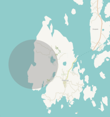
The geologic dome structure above an intrusion, near the isle of Seglinge, Kumlinge community, Åland.
Summary
[edit]
| Description |
Nederlands: De grijze cirkel markeert de structuur, die met enige moeite op luchtfoto's te herkennen is.
English: The grey circle marks the structure. It can be recognised with some effort on aerial photographs. |
| Date | 02-09-2022 |
| Source | Own work |
| Author | Erik Wannee. Original image from Open Street Maps. |
Licensing
[edit]
I, the copyright holder of this work, hereby publish it under the following license:
This file is licensed under the Creative Commons Attribution-Share Alike 4.0 International license.
- You are free:
- to share – to copy, distribute and transmit the work
- to remix – to adapt the work
- Under the following conditions:
- attribution – You must give appropriate credit, provide a link to the license, and indicate if changes were made. You may do so in any reasonable manner, but not in any way that suggests the licensor endorses you or your use.
- share alike – If you remix, transform, or build upon the material, you must distribute your contributions under the same or compatible license as the original.
File history
Click on a date/time to view the file as it appeared at that time.
| Date/Time | Thumbnail | Dimensions | User | Comment | |
|---|---|---|---|---|---|
| current | 11:09, 2 September 2022 | | 674 × 716 (87 KB) | Erik Wannee (talk | contribs) | Uploaded own work with UploadWizard |
You cannot overwrite this file.
File usage on Commons
The following page uses this file:
File usage on other wikis
The following other wikis use this file:
- Usage on nl.wikipedia.org