File:Selig's Dry Goods Company Building.jpg
Jump to navigation
Jump to search

Size of this preview: 450 × 600 pixels. Other resolutions: 180 × 240 pixels | 360 × 480 pixels | 576 × 768 pixels | 768 × 1,024 pixels | 2,112 × 2,816 pixels.
Original file (2,112 × 2,816 pixels, file size: 2.57 MB, MIME type: image/jpeg)
Captions
Captions
Add a one-line explanation of what this file represents
|
This is an image of a place or building that is listed on the National Register of Historic Places in the United States of America. Its reference number is 84001190. |
| Camera location | | View this and other nearby images on: OpenStreetMap |
|---|
| Description |
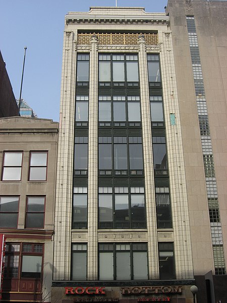
English: Front of the Selig's Dry Goods Company Building, located on the northwestern corner of the junction of Meridian and Washington Streets in downtown Indianapolis, Indiana, United States. Built in 1924 and currently the home of a Rock Bottom Brewery, it is listed on the National Register of Historic Places, and it is a part of the Register-listed Washington Street-Monument Circle Historic District. |
||
| Date | Taken on 4 January 2010 | ||
| Source | Own work | ||
| Author | Nyttend | ||
| Permission (Reusing this file) |
|
File history
Click on a date/time to view the file as it appeared at that time.
| Date/Time | Thumbnail | Dimensions | User | Comment | |
|---|---|---|---|---|---|
| current | 01:55, 9 January 2010 | | 2,112 × 2,816 (2.57 MB) | Nyttend (talk | contribs) | {{Location|39|46|2|N|86|9|30|W}} {{Information |Description={{en|Front of the {{w|Selig's Dry Goods Company Building}}, located on the northwestern corner of the junction of Meridian and Washington Streets in downtown {{w|Indianapolis}}, {{w|Indiana}}, {{ |
You cannot overwrite this file.
File usage on Commons
There are no pages that use this file.
File usage on other wikis
The following other wikis use this file:
- Usage on en.wikipedia.org
- Usage on www.wikidata.org
Metadata
Categories:
- Built in Indianapolis in 1924
- Beaux-Arts architecture in Indianapolis
- Former breweries in Indianapolis
- Office buildings in Indianapolis
- Stone buildings in Indianapolis
- Washington Street-Monument Circle Historic District
- Former restaurants in Indianapolis
- Former shops in Indianapolis
- Built in Indianapolis in 1933
- 2010 in Indianapolis
- January 2010 in Indiana