File:Serbia1849 04.png
Aller à la navigation
Aller à la recherche

Taille de cet aperçu : 457 × 599 pixels. Autres résolutions : 183 × 240 pixels | 366 × 480 pixels | 724 × 949 pixels.
Fichier d’origine (724 × 949 pixels, taille du fichier : 71 kio, type MIME : image/png)
Légendes
Légendes
Ajoutez en une ligne la description de ce que représente ce fichier
Description
[modifier]
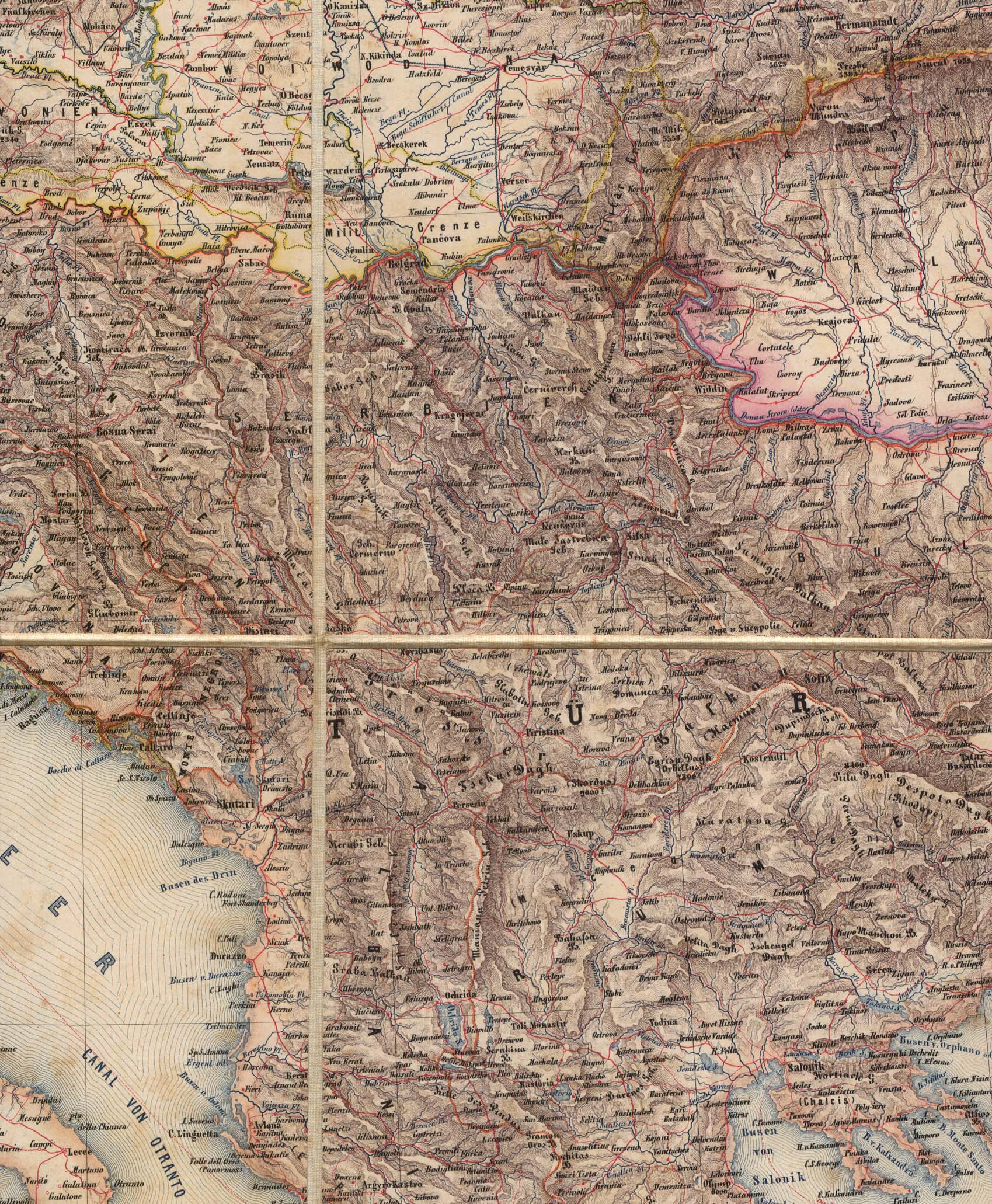
- English: Two autonomous historical territories named Serbia: 1. Principality of Serbia within Ottoman Empire (1833-1878), and 2. Voivodeship of Serbia and Banat of Temeschwar within Austrian Empire (1849-1860) - Serbian language map version
- Serbian: Две аутономне историјске територије са називом Србија: 1. Кнежевина Србија у оквиру Отоманског царства (1833-1878) и 2. Војводство Србија и Тамишки Банат у оквиру Аустријског царства (1849-1860) - верзија мапе на српском језику
References
[modifier]
Published references:
- Зоран Стевановић, Војводство Србија и Тамишки Банат (1849-1861), Архив Војводине, Нови Сад, 2014.
- The Times History of Europe, Times Books, 2002.
- Sima M. Ćirković, Srbi među evropskim narodima, Beograd, 2004.
- Dr Tomislav Bogavac, Nestajanje Srba, Niš, 1994.
- Dragomir Jankov, Vojvodina - propadanje jednog regiona, Novi Sad, 2004.
- Istorijski atlas, Zavod za udžbenike i nastavna sredstva - Zavod za kartografiju "Geokarta", Beograd, 1999.
- Školski istorijski atlas, Zavod za izdavanje udžbenika Socijalističke Republike Srbije, Beograd, 1970.
- Peter Rokai - Zoltan Đere - Tibor Pal - Aleksandar Kasaš, Istorija Mađara, Beograd, 2002.
- Lazo M. Kostić, Srpska Vojvodina i njene manjine, Novi Sad, 1999.
- Drago Njegovan, Prisajedinjenje Vojvodine Srbiji, Novi Sad, 2004.
- Čedomir Popov - Jelena Popov, Autonomija Vojvodine - srpsko pitanje, Sremski Karlovci, 2000.
- Dr Dušan J. Popović, Srbi u Vojvodini, knjiga 3, Novi Sad, 1990.
- J. H. Šviker, Politička istorija Srba u Ugarskoj, Novi Sad - Beograd, 1998.
- Sigfrid Kaper, Srpski pokret u južnoj Ugarskoj 1848-1849, Beograd - Valjevo, 1996.
- Dimitrije Boarov, Politička istorija Vojvodine, Novi Sad, 2001.
- Dejan Mikavica, Srpska Vojvodina u Habsburškoj monarhiji 1690-1920, Novi Sad, 2005.
- Dr Milenko Palić, Srbi u Mađarskoj - Ugarskoj do 1918, Novi Sad, 1995.
- Drago Njegovan, Srpska Vojvodina, Enciklopedija Novog Sada, knjiga 26, Novi Sad, 2005.
- Istorija Vojvodine, Enciklopedija Novog Sada, sveska 5, Novi Sad, 1996.
- Vladimir Ćorović, Ilustrovana istorija Srba, knjiga peta, Beograd, 2006.
- Vasilije Krestić, Iz prošlosti Srema, Bačke i Banata, Beograd, 2003.
- Slavko Gavrilović, Srbi u Habsburškoj Monarhiji (1792-1849), Novi Sad, 1994.
- Milan Tutorov, Banatska rapsodija, Novi Sad, 2001.
- Jovan M. Pejin, Iz prošlosti Kikinde, Kikinda, 2000.
- Rodoljub Malenčić, Miletić, Novi Sad, 1996.
- Čedomir Popov - Slavko Gavrilović, Evropska revolucija i srpski pokret 1848-1849, Beograd - Novi Sad, 1997.
Internet references:
- Bahovo doba - Vojvodstvo Srbija i Tamiški Banat (in Serbian)
- Titles of Habsburg emperors
- Map
- Map
- Map
- Map
- Map
Source and licence
[modifier]
Self-made map by PANONIAN
| Cette œuvre a été placée dans le domaine public par son auteur, PANONIAN. Ceci s’applique dans le monde entier. Dans certains pays, ceci peut ne pas être possible ; dans ce cas : |
Historique du fichier
Cliquer sur une date et heure pour voir le fichier tel qu'il était à ce moment-là.
| Date et heure | Vignette | Dimensions | Utilisateur | Commentaire | |
|---|---|---|---|---|---|
| actuel | 8 octobre 2013 à 14:25 | | 724 × 949 (71 kio) | PANONIAN (d | contributions) | aesthetics |
| 24 décembre 2009 à 10:28 |  | 717 × 944 (71 kio) | PANONIAN (d | contributions) | aesthetics | |
| 15 juin 2009 à 09:38 |  | 717 × 944 (71 kio) | PANONIAN (d | contributions) | since this was a duplicate of another file (File:Serbia02.png), I translated this one into Serbian language | |
| 1 juin 2009 à 18:51 |  | 717 × 944 (73 kio) | PANONIAN (d | contributions) | ||
| 8 mars 2009 à 20:08 |  | 522 × 613 (87 kio) | PANONIAN (d | contributions) | Self-made map by PANONIAN {{PD-user|PANONIAN}} Category:Maps of the history of Serbia Category:Maps of the history of Vojvodina |
Vous ne pouvez pas remplacer ce fichier.
Utilisations locales du fichier
Les 2 pages suivantes utilisent ce fichier :
Utilisations du fichier sur d’autres wikis
Les autres wikis suivants utilisent ce fichier :
- Utilisation sur fr.wikipedia.org
- Utilisation sur mk.wikipedia.org
- Utilisation sur sr.wikipedia.org
Catégories :
- Voivodeship of Serbia and Banat of Temeschwar
- Maps of the Principality of Serbia
- Maps of the Habsburg Military Frontier
- Maps of the Ottoman period in the history of Serbia
- Maps of the Habsburg period in the history of Serbia
- Maps of the history of Serbia in modern times
- Maps of the history of Vojvodina
- Maps of vassal states of the Ottoman Empire
- Serbian-language maps showing history