File:Serbia and Vojvodina 1848.png
跳至導覽
跳至搜尋
預覽大小:465 × 599 像素。 其他解析度:186 × 240 像素 | 372 × 480 像素 | 717 × 924 像素。
原始檔案 (717 × 924 像素,檔案大小:71 KB,MIME 類型:image/png)
說明
說明
添加單行說明來描述出檔案所代表的內容

|
本圖片是以PNG、GIF或JPEG格式上傳。然而,其中包含的資料或訊息,應該重新建立成可縮放向量圖形(SVG)檔案,以更有效率或更準確的方式儲存。如有可能,請上傳本圖片的SVG格式版本。在上傳之後,請修改維基各姊妹計畫中所有使用舊版圖片的條目(列在圖像連結章節中),替換為新版圖片,並在舊圖片的描述頁中加入{{Vector version available|新圖片名稱.svg}}模板,同時移除本模板。
|
| 描述 |
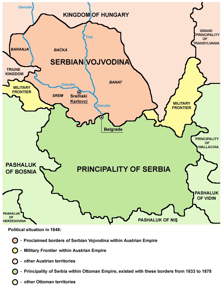
English: Principality of Serbia (autonomous principality within the Ottoman Empire) and Serbian Vojvodina (proclaimed autonomous voivodeship within the Austrian Empire) in 1848.
Српски / srpski: Kneževina Srbija (autonomna kneževina u okviru Osmanskog carstva) i Srpska Vojvodina (proklamovano autonomno vojvodstvo u okviru Austrijskog carstva) 1848. godine. |
| 日期 | (UTC) |
| 來源 | |
| 作者 |
|
| 此作品已由其作者,PANONIAN,釋出至公有領域。此授權條款在全世界均適用。 這可能在某些國家不合法,如果是的話: |
References
[編輯]
- Školski istorijski atlas, Zavod za izdavanje udžbenika Socijalističke Republike Srbije, Beograd, 1970.
- Dragomir Jankov, Vojvodina - propadanje jednog regiona, Novi Sad, 2004.
- Sima M. Ćirković, Srbi među evropskim narodima, Beograd, 2004.
- Dr Tomislav Bogavac, Nestajanje Srba, Niš, 1994.
- Milutin Perović - Milo Strugar, Istorija za 7. razred osnovne škole, Beograd - Novi Sad, 1993.
- Milutin Perović - Relja Novaković, Istorija za III razred gimnazije (opšti tip i društveno-jezički smer) i stručnih škola, Beograd, 1997.
原始上傳日誌
[編輯]
This image is a derivative work of the following images:
- File:Vojvodina03.png licensed with PD-user
- 2009-07-08T19:21:05Z PANONIAN 638x737 (69422 Bytes)
- 2009-04-25T10:30:14Z PANONIAN 638x737 (75852 Bytes)
- 2008-11-01T10:11:08Z PANONIAN 638x547 (23392 Bytes)
- 2008-02-14T19:35:57Z Imbris 638x547 (18702 Bytes) Colour enhancement.
- 2007-05-01T12:14:18Z Tene 638x547 (92663 Bytes) Optimised (0)
- 2007-02-06T16:41:01Z Walden69 638x547 (129561 Bytes) Map of Vojvodina, 1848 from [[en:Image:Vojvodina03.png]] {{PD-user|PANONIAN}} [[Category:Maps of Europe]]
Uploaded with derivativeFX
檔案歷史
點選日期/時間以檢視該時間的檔案版本。
| 日期/時間 | 縮圖 | 尺寸 | 用戶 | 備註 | |
|---|---|---|---|---|---|
| 目前 | 2010年1月15日 (五) 16:36 | | 717 × 924(71 KB) | PANONIAN(對話 | 貢獻) | Reverted to version as of 16:00, 15 January 2010 - fixing thumbnail problem |
| 2010年1月15日 (五) 16:34 |  | 1,000 × 1,050(155 KB) | PANONIAN(對話 | 貢獻) | Reverted to version as of 14:07, 8 January 2010 - fixing thumbnail problem | |
| 2010年1月15日 (五) 16:00 |  | 717 × 924(71 KB) | PANONIAN(對話 | 貢獻) | improved version | |
| 2010年1月8日 (五) 14:07 |  | 1,000 × 1,050(155 KB) | Mladifilozof(對話 | 貢獻) | {{Information |Description=Principality of Serbia (autonomous region within the Ottoman Empire) and Serbian Vojvodina (selfproclaimed autonomous region within the [[:en:Austri |
無法覆蓋此檔案。
檔案用途
下列2個頁面有用到此檔案:
全域檔案使用狀況
以下其他 wiki 使用了這個檔案:
- cy.wikipedia.org 的使用狀況
- el.wikipedia.org 的使用狀況
- en.wikipedia.org 的使用狀況
- ga.wikipedia.org 的使用狀況
- gl.wikipedia.org 的使用狀況
- he.wikipedia.org 的使用狀況
- hr.wikipedia.org 的使用狀況
- hu.wikipedia.org 的使用狀況
- hy.wikipedia.org 的使用狀況
- it.wikipedia.org 的使用狀況
- ja.wikipedia.org 的使用狀況
- lt.wikipedia.org 的使用狀況
- mk.wikipedia.org 的使用狀況
- pt.wikipedia.org 的使用狀況
- ru.wikipedia.org 的使用狀況
- sl.wikipedia.org 的使用狀況
- sq.wikipedia.org 的使用狀況
- sv.wikipedia.org 的使用狀況
- zh.wikipedia.org 的使用狀況
分類:
- Serbian Vojvodina
- Maps of the Principality of Serbia
- Maps of the Habsburg Military Frontier
- Maps of vassal states of the Ottoman Empire
- Maps of the history of Banat
- Maps of the history of Baranja
- Maps of the history of Bačka
- Maps of the Ottoman period in the history of Serbia
- Maps of the Habsburg period in the history of Serbia
- Maps of the history of Serbia in modern times
- Maps of the history of Syrmia
- Maps of the history of Vojvodina
- Maps of proposed subdivisions of Serbia