File:Serbia in the Yugoslav Wars.png
Archivo original (1285 × 892 píxeles; tamaño de archivo: 130 kB; tipo MIME: image/png)
Leyendas
Leyendas

|
Esta imagen debería volverse a crear como imágenes vectoriales SVG. Esto proporciona muchas ventajas, véase Commons:Media for cleanup (en inglés) para más información. Si ya hay una versión SVG de esta imagen disponible, por favor súbala a Commons. Tras subirla, reemplace esta plantilla con la plantilla
{{vector version available|nuevo nombre de imagen.svg}} en esta imagen. |
Resumen[editar]
| Descripción |
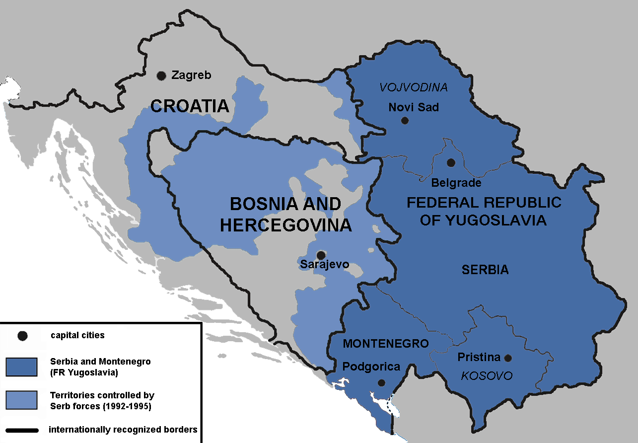
English: Territories of the Republic of Bosnia and Herzegovina and the Republic of Croatia controlled by the Serb forces, after the Operation Corridor (July 1992) in the Yugoslav Wars.
According to the prosecution of War Crimes Tribunal, "Serbian forces" included Yugoslav Army, Serb Territorial Defense of Bosnia and Herzegovina and Croatia, Republic of Srpska Krajina Army, Army of the Republika Srpska, territorial defense of Serbia and Montenegro, Police of Serbia and Police of Republika Srpska, including national security, special police forces of Krajina known as "Martićevci", as well as all Serbian paramilitary forces and volunteer units.[1] Croatia declared independence on June 25, 1991. It was internationally recognized on 15 January 1992 by the United Nations. Bosnia and Herzegovina declared independence on March 5 1992. It was internationally recognized on 22 May 1992 by the United Nations. Serbia and Montenegro proclaimed FR Yugoslavia as a sole successor state of SFR Yugoslavia, on April 27 1992. It remained unrecognized during the conflict (1991-1995). |
||
| Fecha | |||
| Fuente | Trabajo propio | ||
| Autor | Mladifilozof | ||
| Permiso (Reutilización de este archivo) |
Yo, titular de los derechos de autor de esta obra, la publico en los términos de las siguientes licencias: Este archivo se encuentra bajo la licencia Creative Commons Genérica de Atribución/Compartir-Igual 3.0.
Puedes usar la licencia que prefieras. |
||
| Otras versiones |
|


- ↑ Šešelj ICTY Case information sheet (retrieved 10.07.2009.)
Historial del archivo
Haz clic sobre una fecha y hora para ver el archivo tal como apareció en ese momento.
| Fecha y hora | Miniatura | Dimensiones | Usuario | Comentario | |
|---|---|---|---|---|---|
| actual | 16:09 13 ene 2019 | | 1285 × 892 (130 kB) | Illegitimate Barrister (discusión | contribs.) | labelled FRoY |
| 23:50 11 ago 2012 |  | 1285 × 892 (106 kB) | DIREKTOR (discusión | contribs.) | Small fix | |
| 00:14 3 abr 2012 |  | 1285 × 892 (76 kB) | Phoenix B 1of3 (discusión | contribs.) | The blue map appears clearer and easier to understand | |
| 11:34 2 abr 2012 |  | 1285 × 892 (83 kB) | Fezz5555 (discusión | contribs.) | Returning the original previous image of the author. | |
| 23:27 10 dic 2011 |  | 1285 × 892 (76 kB) | DIREKTOR (discusión | contribs.) | Colour | |
| 04:12 22 feb 2010 |  | 1285 × 892 (83 kB) | Mladifilozof (discusión | contribs.) | improved | |
| 20:24 16 feb 2010 |  | 1285 × 892 (89 kB) | Mladifilozof (discusión | contribs.) | {{Information |Description={{en|1=Territories of the Republic of Bosnia and Herzegovina and the Republic of Croatia controlled by the Serbian forces during the [[:en:Yugoslav Wars|Yugo |
No puedes sobrescribir este archivo.
Usos del archivo
Las siguientes páginas usan este archivo:
Uso global del archivo
Las wikis siguientes utilizan este archivo:
- Uso en ar.wikipedia.org
- Uso en azb.wikipedia.org
- Uso en az.wikipedia.org
- Uso en be.wikipedia.org
- Uso en bg.wikipedia.org
- Uso en bs.wikipedia.org
- Uso en ca.wikipedia.org
- Uso en cs.wikipedia.org
- Uso en da.wikipedia.org
- Uso en de.wikipedia.org
- Uso en el.wikipedia.org
- Uso en en.wikipedia.org
- Siege of Sarajevo
- Greater Serbia
- Bosnian genocide
- Republika Srpska (1992–1995)
- Talk:Republika Srpska (1992–1995)
- Croatian War of Independence
- Talk:Joint criminal enterprise
- Talk:Republic of Bosnia and Herzegovina
- Talk:Bosnian War/Archive 3
- Serbia in the Yugoslav Wars
- Talk:Republic of Serbian Krajina/Archive 3
- Talk:Bosnian genocide/Archive 4
- Wikipedia:Graphics Lab/Map workshop/Archive/Oct 2011
- User:Phoenix B 1of3/Stop Greater Serbia
- Talk:Slobodan Milošević/Archive 2
- Talk:Siege of Sarajevo/Archive 1
- Agreement on Friendship and Cooperation between Bosnia and Herzegovina and Croatia
- Talk:Operation Corridor 92/Archive 1
- Proposed secession of Republika Srpska
- Talk:History of Serbia/Archive 1
- Talk:Republic of Serbia (1992–2006)/Archive 1
- Talk:Russia/Archive 16
- User:Falcaorib/Serbia, Yugoslavia and Albania
- Battles of Ilidža
- Uso en es.wikipedia.org
- Uso en eu.wikipedia.org
- Uso en fr.wikipedia.org
- Uso en gl.wikipedia.org
Ver más uso global de este archivo.
Metadatos
- Maps of Greater Serbia
- Maps of the history of Serbia in modern times
- Maps of the history of Montenegro in modern times
- Maps of the history of Republika Srpska
- Maps of the Republic of Serbian Krajina
- Maps of the history of Kosovo in modern times
- Maps of the history of Vojvodina
- Maps of the Yugoslav wars
- Maps of the Bosnian War
- Maps of the Croatian War of Independence
- Maps of the history of the modern Balkans
- Maps of Kosovo and Metohija
- Maps of Republika Srpska (1992-1995)