File:Shag Harbour Nova Scotia.gif
Jump to navigation
Jump to search
No higher resolution available.
Shag_Harbour_Nova_Scotia.gif (405 × 405 pixels, file size: 75 KB, MIME type: image/gif, 0.1 s)
Captions
Captions
Add a one-line explanation of what this file represents
Summary[edit]
| Description |
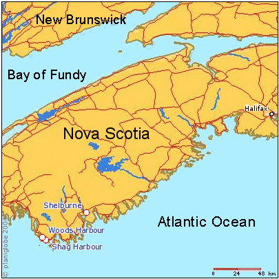
English: Map of southern Nova Scotia, Canada, showing location of Shag Harbour, N.S. and other locations involved in the 1967 Shag Harbour UFO incident. |
| Date | Unknown date |
| Source | Planiglobe |
| Author | Planiglobe |
Licensing[edit]
| This image is from Planiglobe. All maps hosted on Planiglobe are licensed under the Creative Commons Attribution 2.5 License, but Planiglobe suggests that they not be used for navigational purposes. For the purposes of this license, this clause is considered a disclaimer and not a license restriction. This file is licensed under the Creative Commons Attribution 2.5 Generic license.
|

|
This map image could be re-created using vector graphics as an SVG file. This has several advantages; see Commons:Media for cleanup for more information. If an SVG form of this image is available, please upload it and afterwards replace this template with
{{vector version available|new image name}}.
It is recommended to name the SVG file “Shag Harbour Nova Scotia.svg”—then the template Vector version available (or Vva) does not need the new image name parameter. |
File history
Click on a date/time to view the file as it appeared at that time.
| Date/Time | Thumbnail | Dimensions | User | Comment | |
|---|---|---|---|---|---|
| current | 17:28, 13 September 2011 | | 405 × 405 (75 KB) | SreeBot (talk | contribs) | (Original text) : spelling corrections (Harbor -> Harbour) |
| 17:28, 13 September 2011 |  | 405 × 405 (104 KB) | SreeBot (talk | contribs) | (Original text) : Map of southern Nova Scotia, Canada, showing location of Shag Harbour, N.S. and other locations involved in the 1967 Shag Harbour UFO incident. User-made map derived from planiform.com, under their Creative Commons Attribution 2.5 lic |
You cannot overwrite this file.
File usage on Commons
There are no pages that use this file.
File usage on other wikis
The following other wikis use this file:
- Usage on en.wikipedia.org
- Usage on fr.wikipedia.org
- Usage on sr.wikipedia.org
- Usage on vi.wikipedia.org
- Usage on zh.wikipedia.org