File:Sheridan-Richmond 1864.png
Jump to navigation
Jump to search
Size of this preview: 565 × 599 pixels. Other resolutions: 226 × 240 pixels | 452 × 480 pixels | 672 × 713 pixels.
Original file (672 × 713 pixels, file size: 910 KB, MIME type: image/png)
Captions
Captions
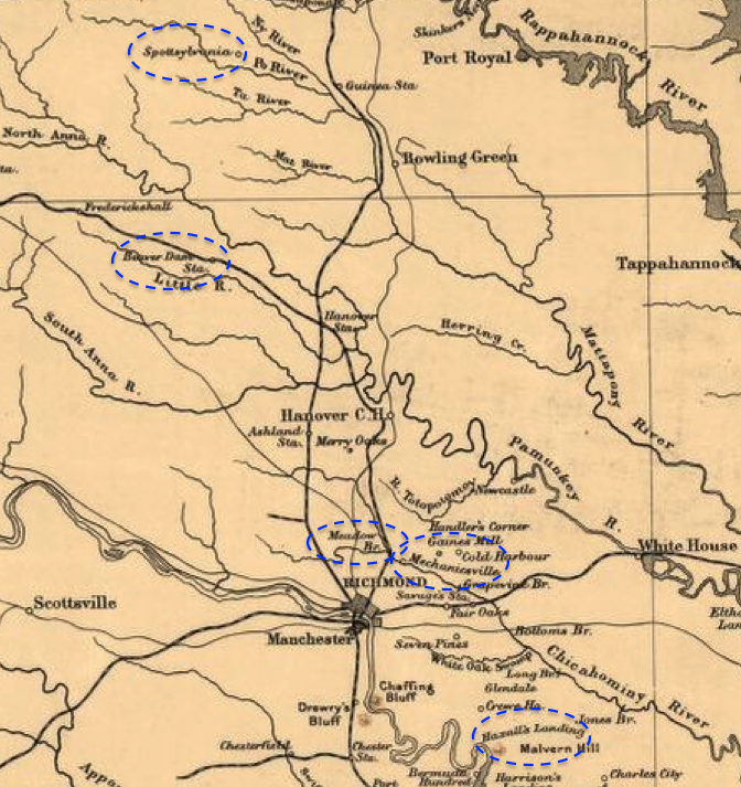
Richmond area during Sheridan's Richmond Raid May 1864
Summary[edit]
| Description |
English: This map shows the area between Richmond and Spotsylvania in Virginia with a few circles around a few of the points cited in the diary of Major John W. Phillips of the 18th Pennsylvania Cavalry. |
| Date | |
| Source | This is a portion of a 1912 map created by Sifton, Praed & Co. that has been modified by TwoScarsUp. The entire map can be found in the Library of Congress map, and shows Virginia and Maryland. Points of interest are circled. Source is portions of the Civil War Diary of John Wilson Phillips, by John Wilson Phillips and Robert G. Athearn. It appeared in the Virginia Magazine of History and Biography Vol. 62, No. 1 (Jan., 1954), pp. 95-123, and was published by the Virginia Historical Society. Spotsylvania Court House is discussed on page 101, as is Beaver Dam Station. Meadow Bridge is discussed on page 102. Gaine's Mills and Malvern Hills are mentioned on page 103. |
| Author | Sifton, Praed & Company, Ltd. modified by TwoScarsUp |
Licensing[edit]
This work is in the public domain in the United States because it was published (or registered with the U.S. Copyright Office) before January 1, 1929.
Public domain works must be out of copyright in both the United States and in the source country of the work in order to be hosted on the Commons. If the work is not a U.S. work, the file must have an additional copyright tag indicating the copyright status in the source country.
Note: This tag should not be used for sound recordings. |
File history
Click on a date/time to view the file as it appeared at that time.
| Date/Time | Thumbnail | Dimensions | User | Comment | |
|---|---|---|---|---|---|
| current | 20:35, 10 April 2020 | | 672 × 713 (910 KB) | TwoScarsUp (talk | contribs) | Uploaded a work by Sifton, Praed & Company, Ltd. modified by TwoScarsUp from This is a portion of a 1912 map created by Sifton, Praed & Co. that has been modified by TwoScarsUp. The entire map can be found in the Library of Congress [https://www.loc.gov/item/99448878/ map], and shows Virginia and Maryland. with UploadWizard |
You cannot overwrite this file.
File usage on Commons
The following page uses this file:
File usage on other wikis
The following other wikis use this file:
- Usage on en.wikipedia.org