File:Shirak.svg
Jump to navigation
Jump to search

Size of this PNG preview of this SVG file: 587 × 599 pixels. Other resolutions: 235 × 240 pixels | 470 × 480 pixels | 752 × 768 pixels | 1,003 × 1,024 pixels | 2,006 × 2,048 pixels | 725 × 740 pixels.
Original file (SVG file, nominally 725 × 740 pixels, file size: 72 KB)
Captions
Captions
Add a one-line explanation of what this file represents
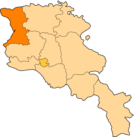
| Description | Image shows the eleven administrative subdivisions of Armenia: # Aragatsotn (Արագածոտնի) # Ararat (Արարատի) # Armavir (Արմավիրի) # Gegharkunik (Գեղարքունիքի) # Kotayk (Կոտայքի) # Lori (Լոռու) # Shirak (Շիրակի) # Syunik (Սյունիքի) # Tavush (Տավուշի) # Vayots Dzor (Վայոց Ձորի) # Yerevan (Երևան) - special administrative status Derived from a multiple of public sources and created using Inkscape. == |
| Date | (UTC) |
| Source | |
| Author |
|
| This is a retouched picture, which means that it has been digitally altered from its original version. Modifications: Creation d'une autre map. The original can be viewed here: Armenia map numbered.svg:
|
This file is licensed under the Creative Commons Attribution-Share Alike 3.0 Unported license.
- You are free:
- to share – to copy, distribute and transmit the work
- to remix – to adapt the work
- Under the following conditions:
- attribution – You must give appropriate credit, provide a link to the license, and indicate if changes were made. You may do so in any reasonable manner, but not in any way that suggests the licensor endorses you or your use.
- share alike – If you remix, transform, or build upon the material, you must distribute your contributions under the same or compatible license as the original.
Original upload log
[edit]
This image is a derivative work of the following images:
- File:Armenia_map_numbered.svg licensed with Cc-by-sa-3.0-migrated, GFDL
- 2010-09-26T17:27:10Z 6AND5 725x740 (82221 Bytes) Reverted to version as of 17:31, 25 November 2006 (((Exclaves deleted according to official map at http://www.gov.am/en/regions/)))
- 2006-11-25T19:37:43Z Bastique 725x740 (87638 Bytes) Cleanup
- 2006-11-25T19:26:57Z Bastique 725x740 (86083 Bytes) Enclaves
- 2006-11-25T17:31:38Z Bastique 725x740 (82221 Bytes) Fixed canvas size
- 2006-11-25T17:27:59Z Bastique 744x1052 (79767 Bytes) Image shows the subdivisions of Armenia. Derived from a multiple of public sources and created using Inkscape. == Licensing == {{GFDL}} Image shows the eleven administrative subdivisions of Armenia: #[[Aragatsotn]] (Ար�
Uploaded with derivativeFX
File history
Click on a date/time to view the file as it appeared at that time.
| Date/Time | Thumbnail | Dimensions | User | Comment | |
|---|---|---|---|---|---|
| current | 12:12, 30 December 2010 | | 725 × 740 (72 KB) | Varmin (talk | contribs) | {{Information |Description=Image shows the eleven administrative subdivisions of Armenia: # Aragatsotn (Արագածոտնի) # Ararat (Արարատի) # Armavir (Արմավիրի) # Gegharkunik (Գեղ |
You cannot overwrite this file.
File usage on Commons
The following page uses this file:
File usage on other wikis
The following other wikis use this file:
- Usage on ar.wikipedia.org
- Usage on be.wikipedia.org
- Usage on bg.wikipedia.org
- Гюмри
- Ширак
- Арпени
- Маралик
- Артик
- Геганист (област Ширак)
- Наапетаван
- Шаблон:Област Ширак
- Агворик
- Агин (село)
- Азатан
- Айгабац
- Айкаван (област Ширак)
- Айкадзор
- Айкасар
- Айреняц
- Алвар (област Ширак)
- Амасия (област Ширак)
- Аниаван
- Анипемза
- Анушаван
- Аравет
- Арапи
- Арденис
- Аревик (област Ширак)
- Аревшат (област Ширак)
- Арташен (област Ширак)
- Арегнадем
- Арич
- Ахурик
- Ахурян (село)
- Ацик (област Ширак)
- Ашоцк
- Бавра
- Баграван
- Бандиван
- Барцрашен (Ширак)
- Башгюх
- Баяндур
- Бениамин
- Бердашен (област Ширак)
- Вахрамаберд
- Вардакар
- Вардахпюр
View more global usage of this file.