File:Shoemaker Impact Structure, Western Australia.JPG
跳转到导航
跳转到搜索
本预览的尺寸:800 × 531像素。 其他分辨率:320 × 213像素 | 640 × 425像素 | 1,024 × 680像素 | 1,280 × 850像素 | 2,560 × 1,700像素 | 4,288 × 2,848像素。
原始文件 (4,288 × 2,848像素,文件大小:16.78 MB,MIME类型:image/jpeg)
说明
说明
添加一行文字以描述该文件所表现的内容
摘要[编辑]
| 描述 |
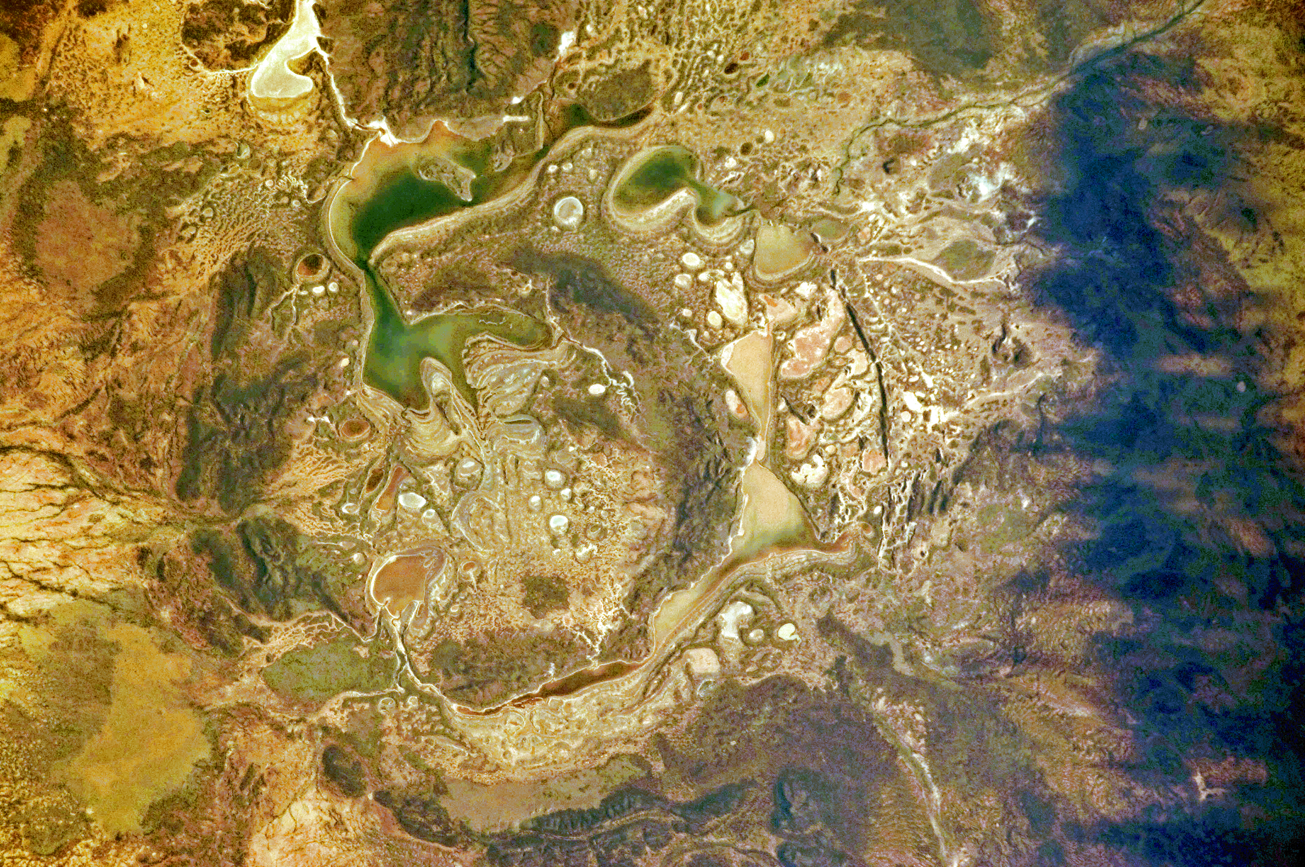
English: The Shoemaker impact site is approximately 30 kilometres in diameter and clearly defined by concentric ring structures formed in sedimentary rocks (brown to dark brown, image centre).
Several saline and ephemeral lakes—Nabberu, Teague, Shoemaker, and numerous smaller ponds—occupy the land surface between the ring structures. Differences in colour result from both water depth and from suspended sediments, with some bright salt crusts visible around the edges of smaller ponds (image centre). |
| 日期 | |
| 来源 | NASA Earth Observatory |
| 作者 | ISS Expedition 28 crew |
| 相机位置 | | 在以下服务上查看本图像和附近其他图像: OpenStreetMap |
|---|
本图像或视频收录于美国国家航空航天局 (NASA)休斯顿太空中心(Johnson Space Center),其照片编号是: ISS028-E-14782 此标签不表示文件的著作权状态。任何文件在附有此标签的同時还需要一个有效的著作权标签。请参阅许可协议说明页面以了解更多信息。 其他语言:
|
Image acquired with a Nikon D2Xs digital camera using a 200 mm lens, and is provided by the ISS Crew Earth Observations experiment and Image Science & Analysis Laboratory, Johnson Space Center.
许可协议[编辑]
| 本文件完全由NASA创作,在美国属于公有领域。根据NASA的版权方针,NASA的材料除非另有声明否则不受版权保护。(参见Template:PD-USGov/zh、NASA版权方针页面或JPL图片使用方针。) | ||
 |
警告:
|
| 註解 | 該圖片含有註解:在維基媒體共享資源上查看註解 |
文件历史
点击某个日期/时间查看对应时刻的文件。
| 日期/时间 | 缩略图 | 大小 | 用户 | 备注 | |
|---|---|---|---|---|---|
| 当前 | 2011年7月19日 (二) 10:12 | | 4,288 × 2,848(16.78 MB) | Originalwana(留言 | 贡献) | {{Information |Description ={{en|1=The Shoemaker impact site is approximately 30 kilometres in diameter and clearly defined by concentric ring structures formed in sedimentary rocks (brown to dark brown, image centre). Several saline and ephemeral |
您不可以覆盖此文件。
文件用途
以下页面使用本文件:
全域文件用途
以下其他wiki使用此文件:
- en.wikipedia.org上的用途
- pl.wikipedia.org上的用途
- ro.wikipedia.org上的用途
- uk.wikipedia.org上的用途
- www.wikidata.org上的用途
- zh.wikipedia.org上的用途