File:Shri Ram Kand Mool, Sold at Bhedaghat - panoramio.jpg
From Wikimedia Commons, the free media repository
Jump to navigation
Jump to search
![File:Shri Ram Kand Mool, Sold at Bhedaghat - panoramio.jpg](https://upload.wikimedia.org/wikipedia/commons/thumb/c/cf/Shri_Ram_Kand_Mool%2C_Sold_at_Bhedaghat_-_panoramio.jpg/800px-Shri_Ram_Kand_Mool%2C_Sold_at_Bhedaghat_-_panoramio.jpg?20161018173407)
Size of this preview: 800 × 555 pixels. Other resolutions: 320 × 222 pixels | 640 × 444 pixels | 1,024 × 710 pixels | 1,280 × 888 pixels | 2,560 × 1,775 pixels | 4,513 × 3,130 pixels.
Original file (4,513 × 3,130 pixels, file size: 3.63 MB, MIME type: image/jpeg)
File information
Structured data
Captions
Captions
Add a one-line explanation of what this file represents
DescriptionShri Ram Kand Mool, Sold at Bhedaghat - panoramio.jpg |
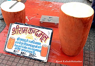
English: Shri Ram Kand Mool, Sold at Bhedaghat. The sign says: Shri Ram Kand Mool. In his 14-year exile, Shri Ram used to eat this Shri Ram Kand Mool. It is sweet, cool, and good for health. Rs. 5, 10, 20 |
||
Date | Taken on 8 September 2016 | ||
Source | https://web.archive.org/web/20161103114803/http://www.panoramio.com/photo/133919032 | ||
Author | Kailash Mohankar | ||
Permission (Reusing this file) |
![]() ![]() This file is licensed under the Creative Commons Attribution 3.0 Unported license. Attribution: Kailash Mohankar
|
||
Other versions |
|
Camera location | 23° 07′ 33.73″ N, 79° 48′ 45.41″ E ![]() | View this and other nearby images on: OpenStreetMap | ![]() |
---|
File history
Click on a date/time to view the file as it appeared at that time.
Date/Time | Thumbnail | Dimensions | User | Comment | |
---|---|---|---|---|---|
current | 17:34, 18 October 2016 | ![]() | 4,513 × 3,130 (3.63 MB) | Panoramio upload bot (talk | contribs) | {{Information |description=Shri Ram Kand Mool, Sold at Bhedaghat |date={{Taken on|2016-09-08}} |source=http://www.panoramio.com/photo/133919032 |author=[http://www.panoramio.com/user/6308781?with_photo_id=133919032 Kailash Mohankar] |permission={{cc-by... |
You cannot overwrite this file.
File usage on Commons
The following page uses this file:
File usage on other wikis
The following other wikis use this file:
- Usage on en.wikipedia.org
- Usage on fr.wikipedia.org
- Usage on ta.wikipedia.org
Metadata
This file contains additional information such as Exif metadata which may have been added by the digital camera, scanner, or software program used to create or digitize it. If the file has been modified from its original state, some details such as the timestamp may not fully reflect those of the original file. The timestamp is only as accurate as the clock in the camera, and it may be completely wrong.
Camera manufacturer | Motorola |
---|---|
Camera model | Moto G (4) |
Author | Kailash Mohankar |
Exposure time | 1/167 sec (0.0059880239520958) |
F-number | f/2 |
ISO speed rating | 64 |
Date and time of data generation | 13:51, 8 September 2016 |
Lens focal length | 4.68 mm |
Latitude | 23° 7′ 33.73″ N |
Longitude | 79° 48′ 45.41″ E |
Altitude | 298 meters above sea level |
Copyright holder |
|
Horizontal resolution | 72 dpi |
Vertical resolution | 72 dpi |
Software used | athene_f-user 6.0.1 MPJ24.139-23.1 1 release-keys |
File change date and time | 22:28, 29 September 2016 |
Y and C positioning | Centered |
Exposure Program | Normal program |
Exif version | 2.2 |
Date and time of digitizing | 13:51, 8 September 2016 |
Meaning of each component |
|
APEX shutter speed | 7.38 |
APEX aperture | 2 |
APEX brightness | −1 |
APEX exposure bias | 0 |
Maximum land aperture | 2 APEX (f/2) |
Metering mode | Average |
Flash | Flash did not fire, auto mode |
Supported Flashpix version | 1 |
Color space | sRGB |
Scene type | A directly photographed image |
Custom image processing | Normal process |
Exposure mode | Auto exposure |
White balance | Auto white balance |
Digital zoom ratio | 1.82 |
Scene capture type | Standard |
Contrast | Normal |
Saturation | Normal |
Sharpness | Soft |
Unique image ID | b190320e6c773b4a22a00896ca463328 |
GPS time (atomic clock) | 08:21 |
Geodetic survey data used | WGS-84 |
GPS date | 8 September 2016 |
GPS tag version | 2.2.0.0 |
IIM version | 4 |