File:Siedlungsgebiete der Afscharen.PNG
Jump to navigation
Jump to search

Size of this preview: 800 × 404 pixels. Other resolutions: 320 × 161 pixels | 640 × 323 pixels | 1,481 × 747 pixels.
Original file (1,481 × 747 pixels, file size: 34 KB, MIME type: image/png)
Captions
Captions
Add a one-line explanation of what this file represents
Summary[edit]
| Description |
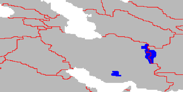
Deutsch: Die Siedlungsgebiete der Afscharen
Darstellungskarte mit den Siedlungsgebieten jener Völker, die sich im Iran und Afghanistan noch als "Afscharen" bezeichnen. Nicht enthalten sind jene Gebiete in der heutigen Türkei, Turkmenistan und Usbekistan, wo sich ebenfalls eine Minderheit zu diesem Volk zählt. Diese sind jedoch als Teil des dortigen Staatsvolkes anzusehen. |
| Date | |
| Source |
Deutsch: Postmann Michael |
| Author | Postmann Michael |
| Permission (Reusing this file) |
Public Domain |
Licensing[edit]

|
The copyright holder of this work allows anyone to use it for any purpose including unrestricted redistribution, commercial use, and modification.
Usage notes:
|
File history
Click on a date/time to view the file as it appeared at that time.
| Date/Time | Thumbnail | Dimensions | User | Comment | |
|---|---|---|---|---|---|
| current | 19:28, 11 February 2005 | | 1,481 × 747 (34 KB) | Postmann Michael (talk | contribs) | Karte etwas überarbeitet und verfeinert. |
| 22:33, 6 February 2005 |  | 280 × 194 (4 KB) | Postmann Michael (talk | contribs) | Die Siedlungsgebiet der Afscharen |
You cannot overwrite this file.
File usage on Commons
There are no pages that use this file.
File usage on other wikis
The following other wikis use this file:
- Usage on de.wikipedia.org