File:Siennica (gmina) location map.png
Jump to navigation
Jump to search

Size of this preview: 546 × 599 pixels. Other resolutions: 219 × 240 pixels | 437 × 480 pixels | 761 × 835 pixels.
Original file (761 × 835 pixels, file size: 135 KB, MIME type: image/png)
Captions
Captions
Add a one-line explanation of what this file represents
| Description |
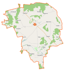
Polski: Mapa gminy Siennica, Polska
English: Map of Gmina Siennica, Poland |
|||||||||
| Date | ||||||||||
| Source | You may find a page on the OpenStreetMap wiki page for Siennica (gmina) | |||||||||
| Creator |
OpenStreetMap contributors OpenStreetMap contributors |
|||||||||
| Permission (Reusing this file) |
OpenStreetMap data is available under the Open Database License (details). Map tiles are licensed under the Creative Commons Attribution-ShareAlike 2.0 license (CC-BY-SA 2.0).
This file is licensed under the Creative Commons Attribution-Share Alike 2.0 Generic license.
|
|||||||||
| Geotemporal data | ||||||||||
| Bounding box |
|
|||||||||
| Georeferencing | If inappropriate please set warp_status = skip to hide. | |||||||||
File history
Click on a date/time to view the file as it appeared at that time.
| Date/Time | Thumbnail | Dimensions | User | Comment | |
|---|---|---|---|---|---|
| current | 10:56, 12 September 2014 | | 761 × 835 (135 KB) | VanWiel (talk | contribs) | |
| 11:19, 10 August 2014 |  | 761 × 835 (166 KB) | VanWiel (talk | contribs) | {{OpenStreetMap | name = Siennica (gmina) | location = Siennica (gmina) | description = {{pl|Mapa gminy Siennica, Polska}} {{en|Map of Gmina Siennica, Poland}} | top = 52.1400 | left = 21.5071 | r... |
You cannot overwrite this file.
File usage on Commons
There are no pages that use this file.
File usage on other wikis
The following other wikis use this file:
- Usage on fr.wikipedia.org
- Usage on lt.wikipedia.org
- Usage on nl.wikipedia.org
- Usage on pl.wikipedia.org
- Siennica (gmina)
- Bestwiny
- Budy Łękawickie
- Drożdżówka (województwo mazowieckie)
- Dłużew
- Dzielnik (województwo mazowieckie)
- Gągolina
- Grzebowilk (wieś)
- Kulki (województwo mazowieckie)
- Kośminy
- Lasomin
- Nowa Pogorzel
- Nowodzielnik
- Nowy Starogród
- Nowy Zglechów
- Strugi Krzywickie
- Świętochy
- Wólka Dłużewska
- Żaków
- Żakówek
- Zglechów
- Chełst (województwo mazowieckie)
- Nowe Zalesie (województwo mazowieckie)
- Nowodwór (województwo mazowieckie)
- Ptaki (województwo mazowieckie)
- Siodło (województwo mazowieckie)
- Starogród (województwo mazowieckie)
- Rezerwat przyrody Wólczańska Góra
- Boża Wola (powiat miński)
- Julianów (powiat miński)
- Kąty (powiat miński)
- Krzywica (powiat miński)
- Łękawica (powiat miński)
- Majdan (powiat miński)
- Pogorzel (powiat miński)
- Siennica
- Stara Wieś (Siennica)
- Swoboda (powiat miński)
- Wojciechówka (powiat miński)
- Borówek (gmina Siennica)
- Dąbrowa (gmina Siennica)
- Zalesie (gmina Siennica)
- Parafia św. Stanisława Biskupa Męczennika w Siennicy
- Grzebowilk (stacja kolejowa)
- Wiśniówka (województwo mazowieckie)
- Kościół Ofiarowania Najświętszej Maryi Panny w Siennicy
- Moduł:Mapa/dane/Siennica (gmina)
View more global usage of this file.
_location_map.png)
_location_map.png&oldid=696163318)