File:Situation in Sievierodonetsk and Lysychansk.svg
Jump to navigation
Jump to search

Size of this PNG preview of this SVG file: 800 × 589 pixels. Other resolutions: 320 × 236 pixels | 640 × 471 pixels | 1,024 × 754 pixels | 1,280 × 943 pixels | 2,560 × 1,886 pixels | 1,226 × 903 pixels.
Original file (SVG file, nominally 1,226 × 903 pixels, file size: 9.62 MB)
Captions
Captions
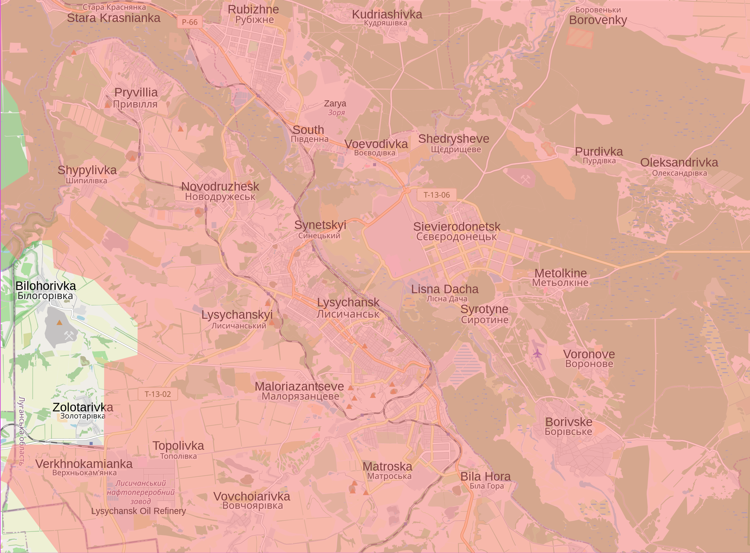
Current situation in and around Sievierodonetsk and Lysychansk
Summary[edit]
| Description |
English: Map showing the current situation in and around Sievierodonetsk and Lysychansk. Land in red is controlled by Russia and the Luhansk and Donbas People's Republics. During the 2022 Russian invasion of Ukraine, Sievierodonetsk came under attack from Russian and Luhansk People's Republic forces, and the battle started on 6 May 2022. On 24 June, Ukrainian forces were ordered to withdraw from Sievierodonetsk and city fell the following day. This left the neighbouring Lysychansk as the only notable part of the Luhansk Oblast that remained under Ukrainian control. In the following days, Russia made advances south of Lysychansk, and entered the city on 25 June. Russia announced that it had control of Lysychansk on 2 July after seven days of fighting. This was initially denied by Ukraine, however, the Ukrainian general staff admitted on 3 July that it gave the order to withdraw from the city. The fall of Lysychansk means that the Luhansk People's Republic has complete control of the Luhansk Oblast. |
| Date | |
| Source |
Own work Control data from the Institute for the Study of War |
| Author | Cyrobyte |
Licensing[edit]
| Description |
This map was created from OpenStreetMap project data, collected by the community. This map may be incomplete, and may contain errors. Don't rely solely on it for navigation. |
|||
| Date | (see file history) | |||
| Source | openstreetmap.org | |||
| Creator |
OpenStreetMap contributors |
|||
| Permission (Reusing this file) |
OpenStreetMap data is available under the Open Database License (details). Map tiles are licensed under the Creative Commons Attribution-ShareAlike 2.0 license (CC-BY-SA 2.0).
This file is licensed under the Creative Commons Attribution-Share Alike 2.0 Generic license.
|
|||
| Georeferencing | If inappropriate please set warp_status = skip to hide. |
I, the copyright holder of this work, hereby publish it under the following license:
| This file is made available under the Creative Commons CC0 1.0 Universal Public Domain Dedication. | |
| The person who associated a work with this deed has dedicated the work to the public domain by waiving all of their rights to the work worldwide under copyright law, including all related and neighboring rights, to the extent allowed by law. You can copy, modify, distribute and perform the work, even for commercial purposes, all without asking permission.
|
File history
Click on a date/time to view the file as it appeared at that time.
| Date/Time | Thumbnail | Dimensions | User | Comment | |
|---|---|---|---|---|---|
| current | 00:21, 28 January 2023 | | 1,226 × 903 (9.62 MB) | Nahabino (talk | contribs) | Update per ISW |
| 20:31, 21 October 2022 |  | 1,226 × 903 (9.62 MB) | Nahabino (talk | contribs) | Update per ISW | |
| 22:20, 5 October 2022 |  | 1,226 × 903 (9.63 MB) | Nahabino (talk | contribs) | Update per ISW | |
| 01:10, 1 October 2022 |  | 1,226 × 903 (9.64 MB) | Nahabino (talk | contribs) | Update per ISW | |
| 14:14, 28 September 2022 |  | 1,226 × 903 (9.73 MB) | Nahabino (talk | contribs) | Bilohorivka | |
| 00:42, 4 July 2022 |  | 1,226 × 903 (9.74 MB) | Cyrobyte (talk | contribs) | Update | |
| 21:51, 2 July 2022 |  | 1,226 × 903 (9.74 MB) | Cyrobyte (talk | contribs) | Update | |
| 03:15, 2 July 2022 |  | 1,226 × 903 (9.74 MB) | Cyrobyte (talk | contribs) | Update | |
| 00:22, 2 July 2022 |  | 1,226 × 903 (9.74 MB) | Cyrobyte (talk | contribs) | Fixed alignment of English labels | |
| 20:21, 1 July 2022 |  | 1,226 × 903 (9.73 MB) | Cyrobyte (talk | contribs) | Update |
You cannot overwrite this file.
File usage on Commons
The following 16 pages use this file:
- User:Jcornelius/Angola/2022 July 1-10
- User:Jcornelius/Angola/2022 June 1-10
- User:Jcornelius/Angola/2022 June 11-20
- User:Jcornelius/Angola/2022 June 21-30
- User:Jcornelius/Angola/2022 October 1-10
- User:Jcornelius/Angola/2022 October 21-31
- User:Jcornelius/Angola/2022 September 21-30
- User:Jcornelius/Angola/2023 January 21-31
- User:Magog the Ogre/Maps of conflicts/2022 July
- User:Magog the Ogre/Maps of conflicts/2022 June
- User:Magog the Ogre/Maps of conflicts/2022 October
- User:Magog the Ogre/Maps of conflicts/2022 September
- User:Magog the Ogre/Maps of conflicts/2023 January
- User:ביקורת/Rabbis/2023 January 28
- Category:Battle of Sievierodonetsk (2022)
- Category:War damages in Lysychansk (2022)
File usage on other wikis
The following other wikis use this file:
- Usage on ar.wikipedia.org
- Usage on ca.wikipedia.org
- Usage on cs.wikipedia.org
- Usage on ja.wikipedia.org
- Usage on ro.wikipedia.org
- Usage on vi.wikipedia.org
- Usage on www.wikidata.org