File:Situation in Sievierodonetsk and Lysychansk.svg
Skočit na navigaci
Skočit na vyhledávání

Velikost tohoto PNG náhledu tohoto SVG souboru: 800 × 589 pixelů. Jiná rozlišení: 320 × 236 pixelů | 640 × 471 pixelů | 1 024 × 754 pixelů | 1 280 × 943 pixelů | 2 560 × 1 886 pixelů | 1 226 × 903 pixelů.
Původní soubor (soubor SVG, nominální rozměr: 1 226 × 903 pixelů, velikost souboru: 9,62 MB)
Popisky
Popisky
Přidejte jednořádkové vysvětlení, co tento soubor představuje
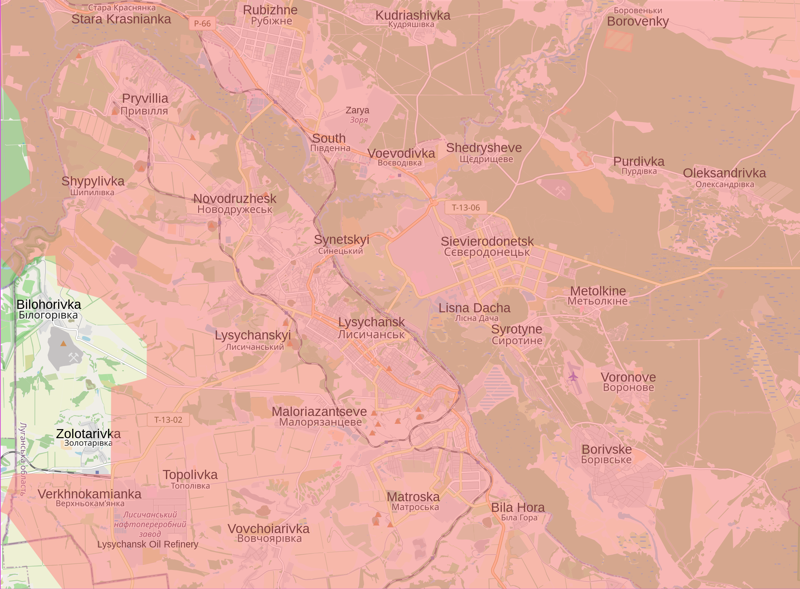
Current situation in and around Sievierodonetsk and Lysychansk
Popis[editovat]
| Popis |
English: Map showing the current situation in and around Sievierodonetsk and Lysychansk. Land in red is controlled by Russia and the Luhansk and Donbas People's Republics. During the 2022 Russian invasion of Ukraine, Sievierodonetsk came under attack from Russian and Luhansk People's Republic forces, and the battle started on 6 May 2022. On 24 June, Ukrainian forces were ordered to withdraw from Sievierodonetsk and city fell the following day. This left the neighbouring Lysychansk as the only notable part of the Luhansk Oblast that remained under Ukrainian control. In the following days, Russia made advances south of Lysychansk, and entered the city on 25 June. Russia announced that it had control of Lysychansk on 2 July after seven days of fighting. This was initially denied by Ukraine, however, the Ukrainian general staff admitted on 3 July that it gave the order to withdraw from the city. The fall of Lysychansk means that the Luhansk People's Republic has complete control of the Luhansk Oblast. |
| Datum | |
| Zdroj |
Vlastní dílo Control data from the Institute for the Study of War |
| Autor | Cyrobyte |
Licence[editovat]
| Popis |
Tato mapa byla vytvořena na základě dat projektu OpenStreetMap, sestavených komunitou. Tato mapa může být neúplná a může obsahovat chyby. Pro navigaci se nespoléhejte výhradně na ni. |
|||
| Datum | (see file history) | |||
| Zdroj | openstreetmap.org | |||
| Tvůrce |
OpenStreetMap contributors |
|||
| Svolení (Užití tohoto souboru) |
OpenStreetMap data is available under the Open Database License (details). Map tiles are licensed under the Creative Commons Attribution-ShareAlike 2.0 license (CC-BY-SA 2.0).
Tento soubor podléhá licenci Creative Commons Uveďte autora-Zachovejte licenci 2.0 Generic
|
|||
| Georeferencing | If inappropriate please set warp_status = skip to hide. |
Já, držitel autorských práv k tomuto dílu, ho tímto zveřejňuji za podmínek následující licence:
| Tento soubor byl uvolněn pomocí Creative Commons CC0 1.0 Universal Public Domain Dedication. | |
| Osoba, která toto dílo označila tímto dokumentem, dílo uvolnila do public domain tím, že se celosvětově vzdala všech autorských práv ke svému dílu včetně všech souvisejících a příbuzných zákonných práv, které k dílu má, v rozsahu umožněném zákonem. Můžete toto dílo rozmnožovat, upravovat, rozšiřovat či provozovat, i pro komerční účely, vše bez nutnosti žádat o svolení.
|
Historie souboru
Kliknutím na datum a čas se zobrazí tehdejší verze souboru.
| Datum a čas | Náhled | Rozměry | Uživatel | Komentář | |
|---|---|---|---|---|---|
| současná | 28. 1. 2023, 00:21 | | 1 226 × 903 (9,62 MB) | Nahabino (diskuse | příspěvky) | Update per ISW |
| 21. 10. 2022, 20:31 |  | 1 226 × 903 (9,62 MB) | Nahabino (diskuse | příspěvky) | Update per ISW | |
| 5. 10. 2022, 22:20 |  | 1 226 × 903 (9,63 MB) | Nahabino (diskuse | příspěvky) | Update per ISW | |
| 1. 10. 2022, 01:10 |  | 1 226 × 903 (9,64 MB) | Nahabino (diskuse | příspěvky) | Update per ISW | |
| 28. 9. 2022, 14:14 |  | 1 226 × 903 (9,73 MB) | Nahabino (diskuse | příspěvky) | Bilohorivka | |
| 4. 7. 2022, 00:42 |  | 1 226 × 903 (9,74 MB) | Cyrobyte (diskuse | příspěvky) | Update | |
| 2. 7. 2022, 21:51 |  | 1 226 × 903 (9,74 MB) | Cyrobyte (diskuse | příspěvky) | Update | |
| 2. 7. 2022, 03:15 |  | 1 226 × 903 (9,74 MB) | Cyrobyte (diskuse | příspěvky) | Update | |
| 2. 7. 2022, 00:22 |  | 1 226 × 903 (9,74 MB) | Cyrobyte (diskuse | příspěvky) | Fixed alignment of English labels | |
| 1. 7. 2022, 20:21 |  | 1 226 × 903 (9,73 MB) | Cyrobyte (diskuse | příspěvky) | Update |
Tento soubor nemůžete přepsat.
Využití souboru
Na Commons na soubor odkazují tyto stránky:
- User:Jcornelius/Angola/2022 July 1-10
- User:Jcornelius/Angola/2022 June 1-10
- User:Jcornelius/Angola/2022 June 11-20
- User:Jcornelius/Angola/2022 June 21-30
- User:Jcornelius/Angola/2022 October 1-10
- User:Jcornelius/Angola/2022 October 21-31
- User:Jcornelius/Angola/2022 September 21-30
- User:Jcornelius/Angola/2023 January 21-31
- User:Magog the Ogre/Maps of conflicts/2022 July
- User:Magog the Ogre/Maps of conflicts/2022 June
- User:Magog the Ogre/Maps of conflicts/2022 October
- User:Magog the Ogre/Maps of conflicts/2022 September
- User:Magog the Ogre/Maps of conflicts/2023 January
- User:ביקורת/Rabbis/2023 January 28
- Category:Battle of Sievierodonetsk (2022)
- Category:War damages in Lysychansk (2022)
Globální využití souboru
Tento soubor využívají následující wiki:
- Využití na ar.wikipedia.org
- Využití na ca.wikipedia.org
- Využití na cs.wikipedia.org
- Využití na ja.wikipedia.org
- Využití na ro.wikipedia.org
- Využití na vi.wikipedia.org
- Využití na www.wikidata.org