File:Siège de Québec en 1759, gravure.svg

Original file (SVG file, nominally 634 × 423 pixels, file size: 7.08 MB)
Captions
Captions
Summary[edit]
| Description |
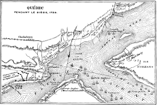
Français : Carte du siège de Québec par les Anglais en 1759. Gravure publiée en 1884. |
| Date | |
| Source | http://bibnum2.banq.qc.ca/bna/numtxt/59302-8.pdf |
| Author | Sulte, Benjamin, 1841-1923* |
| Camera location | | View this and other nearby images on: OpenStreetMap |
|---|
publiée dans le volume 8 de: Histoire des Canadiens-français, 1608-1880 : origine, histoire, religion, guerres, découvertes, colonisation, coutumes, vie domestique, sociale et politique, développement, avenir / par Benjamin Sulte ; ouvrage orné de portraits et de plans Montréal : Wilson & cie, éditeurs, 1882-1884
Licensing[edit]
|
This work is in the public domain in its country of origin and other countries and areas where the copyright term is the author's life plus 70 years or fewer. This work is in the public domain in the United States because it was published (or registered with the U.S. Copyright Office) before January 1, 1929. | |
| This file has been identified as being free of known restrictions under copyright law, including all related and neighboring rights. | |
File history
Click on a date/time to view the file as it appeared at that time.
| Date/Time | Thumbnail | Dimensions | User | Comment | |
|---|---|---|---|---|---|
| current | 03:30, 28 November 2014 | | 634 × 423 (7.08 MB) | Pierre5018 (talk | contribs) | User created page with UploadWizard |
You cannot overwrite this file.
File usage on Commons
There are no pages that use this file.
File usage on other wikis
The following other wikis use this file:
- Usage on fr.wikipedia.org