File:Slavic europe.svg
Перейти к навигации
Перейти к поиску

Размер этого PNG-превью для исходного SVG-файла: 680 × 520 пкс. Другие разрешения: 314 × 240 пкс | 628 × 480 пкс | 1004 × 768 пкс | 1280 × 979 пкс | 2560 × 1958 пкс.
Исходный файл (SVG-файл, номинально 680 × 520 пкс, размер файла: 662 КБ)
Краткие подписи
Краткие подписи
Добавьте однострочное описание того, что собой представляет этот файл

Краткое описание
[править]
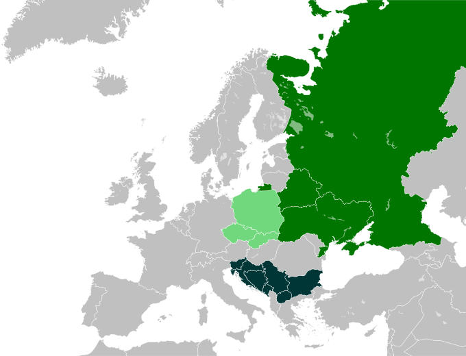
| Описание |
العربية:
بلدان لغاتها الرسمية من اللغات السﻻفية الغربية
بلدان لغاتها الرسمية من اللغات السﻻفية الشرقية
بلدان لغاتها الرسمية من اللغات السﻻفية الجنوبية Беларуская:
Краіны, дзе заходнеславянскія мовы з'яўляюцца дзяржаўнымі
Краіны, дзе ўсходнеславянскія мовы з'яўляюцца дзяржаўнымі
Краіны, дзе паўднёваславянскія мовы з'яўляюцца дзяржаўнымі Български:
Държави с официален език от западнославянски произход
Държави с официален език от източнославянски произход
Държави с официален език от южнославянски произход Čeština:
Státy, ve kterých je národním jazykem jazyk západoslovanský
Státy, ve kterých je národním jazykem jazyk východoslovanský
Státy, ve kterých je národním jazykem jazyk jihoslovanský Deutsch:
Staaten, in denen eine westslawische Sprache die Nationalsprache ist
Staaten, in denen eine ostslawische Sprache die Nationalsprache ist
Staaten, in denen eine südslawische Sprache die Nationalsprache ist English:
Countries where a West Slavic language is the national language
Countries where an East Slavic language is the national language
Countries where a South Slavic language is the national language Esperanto:
Landoj, kies nacia lingvo estas okcidentslava lingvo
Landoj, kies nacia lingvo estas orientslava lingvo
Landoj, kies nacia lingvo estas sudslava lingvo Español:
Países donde la lengua oficial es un idioma eslavo occidental
Países donde la lengua oficial es un idioma eslavo oriental
Países donde la lengua oficial es un idioma eslavo meridional Français :
Pays où la langue nationale est une langue slave occidentale
Pays où la langue nationale est une langue slave orientale
Pays où la langue nationale est une langue slave méridionale עברית:
מדינות בהן שפה סלאבית מערבית היא שפה רשמית
מדינות בהן שפה סלאבית מזרחית היא שפה רשמית
מדינות בהן שפה סלאבית דרומית היא שפה רשמית ქართული:
ქვეყნები, სადაც დასავლეთსლავური ენები არის ეროვნული
ქვეყნები, სადაც აღმოსავლეთსლავური ენები არის ეროვნული
ქვეყნები, სადაც სამხრეთსლავური ენები არის ეროვნული Македонски:
Држави чиј официјален јазик е последица на западнословенски
Држави чиј официјален јазик е последица на источнословенски
Држави чиј официјален јазик е последица на јужнословенски Nederlands:
Landen waar een west-slavische taal de nationale taal is
Landen waar een oost-slavische taal de nationale taal is
Landen waar een zuid-slavische taal de nationale taal is Polski:
Kraje, w których językiem urzędowym jest język zachodniosłowiański
Kraje, w których językiem urzędowym jest język wschodniosłowiański
Kraje, w których językiem urzędowym jest język południowosłowiański Português:
Paises onde a língua nacional é uma língua eslava ocidental
Paises onde a língua nacional é uma língua eslava oriental
Paises onde a língua nacional é uma língua eslava meridional Română:
Țări în care limba națională este o limbă slavă apuseană
Țări în care limba națională este o limbă slavă răsăriteană
Țări în care limba națională este o limbă slavă de sud Русский:
Страны с официальным языком, принадлежащим к западнославянской ветви
Страны с официальным языком, принадлежащим к восточнославянской ветви
Страны с официальным языком, принадлежащим к южнославянской ветви Slovenčina:
Štáty, v ktorých je národným jazykom západoslovanský jazyk
Štáty, v ktorých je národným jazykom východoslovanský jazyk
Štáty, v ktorých je národným jazykom južnoslovanský jazyk Српски / srpski:
Земље у којима је западнословенски национални језик
Земље у којима је источнословенски национални језик
Земље у којима је јужнословенски национални језик Українська: Країни, де західнослов'янські мови є державними
Країни, де східнослов'янські мови є державними
Країни, де південнослов'янські мови є державними |
| Дата | |
| Источник | self-made - based upon: Image:Slavic europe.png |
| Автор | CrazyPhunk |
| Другие версии |
Производные работы от этого файла: |
Лицензирование
[править]

|
Разрешается копировать, распространять и/или изменять этот документ в соответствии с условиями GNU Free Documentation License версии 1.2 или более поздней, опубликованной Фондом свободного программного обеспечения, без неизменяемых разделов, без текстов, помещаемых на первой и последней обложке. Копия лицензии включена в раздел, озаглавленный GNU Free Documentation License. |
| Этот файл доступен по лицензии Creative Commons Attribution-Share Alike 3.0 Unported. | ||
| ||
| Этот признак лицензирования был добавлен к этому файлу как часть обновления лицензии GFDL. |
История файла
Нажмите на дату/время, чтобы увидеть версию файла от того времени.
| Дата/время | Миниатюра | Размеры | Участник | Примечание | |
|---|---|---|---|---|---|
| текущий | 20:24, 9 февраля 2024 | | 680 × 520 (662 КБ) | Ruach Chayim (обсуждение | вклад) | Reverted to version as of 00:00, 23 January 2024 (UTC) |
| 03:04, 28 января 2024 |  | 680 × 520 (800 КБ) | Doublah (обсуждение | вклад) | Reverted to version as of 15:52, 21 January 2024 (UTC) This file is not used for UN recognition, it's about Language. | |
| 00:00, 23 января 2024 |  | 680 × 520 (662 КБ) | JJUPLOADS22 (обсуждение | вклад) | Reverted to version as of 18:30, 27 August 2023 (UTC) Kosovo is not recognized by UN, please don't revert without reasons. | |
| 15:52, 21 января 2024 |  | 680 × 520 (800 КБ) | Doublah (обсуждение | вклад) | Reverted to version as of 12:42, 23 July 2023 (UTC) | |
| 18:30, 27 августа 2023 |  | 680 × 520 (662 КБ) | Ruach Chayim (обсуждение | вклад) | Reverted to version as of 17:32, 8 July 2023 (UTC) undiscussed; Kosovo and Metohija are recognized as part of Serbia by the UN | |
| 12:42, 23 июля 2023 |  | 680 × 520 (800 КБ) | Doublah (обсуждение | вклад) | Reverted to version as of 16:04, 4 July 2023 (UTC) | |
| 17:32, 8 июля 2023 |  | 680 × 520 (662 КБ) | JJUPLOADS22 (обсуждение | вклад) | Reverted to version as of 01:06, 16 January 2022 (UTC) Kosovo is not recognized by UN. | |
| 16:04, 4 июля 2023 |  | 680 × 520 (800 КБ) | HelpfulHens (обсуждение | вклад) | Kosovo is NOT an ethnically Slavic country. | |
| 01:06, 16 января 2022 |  | 680 × 520 (662 КБ) | ApcehCraft (обсуждение | вклад) | Reverted to version as of 20:25, 24 May 2021 (UTC), it was previously reverted without any explanation | |
| 13:56, 29 декабря 2021 |  | 680 × 520 (800 КБ) | Irimed (обсуждение | вклад) | Reverted to version as of 12:27, 2 April 2021 (UTC) |
Вы не можете перезаписать этот файл.
Использование файла
Следующие 23 страницы используют этот файл:
- Atlas of Europe
- User:Chumwa/OgreBot/Travel and communication maps/2021 April 1-10
- User:Chumwa/OgreBot/Travel and communication maps/2021 December 21-31
- User:Chumwa/OgreBot/Travel and communication maps/2021 May 21-31
- User:Chumwa/OgreBot/Travel and communication maps/2022 January 11-20
- User:Chumwa/OgreBot/Travel and communication maps/2023 August 21-31
- User:Chumwa/OgreBot/Travel and communication maps/2023 July 1-10
- User:Chumwa/OgreBot/Travel and communication maps/2023 July 21-31
- User:Chumwa/OgreBot/Travel and communication maps/2024 February 1-9
- User:Chumwa/OgreBot/Travel and communication maps/2024 January 21-31
- User:Magog the Ogre/Multilingual legend/2023 August 27-31
- User:Magog the Ogre/Multilingual legend/2023 July 1-10
- User:Magog the Ogre/Multilingual legend/2023 July 21-31
- User:Magog the Ogre/Multilingual legend/2024 February 5-9
- User:Magog the Ogre/Multilingual legend/2024 January 17-21
- User:Magog the Ogre/Multilingual legend/2024 January 22-26
- User:Magog the Ogre/Multilingual legend/2024 January 27-31
- File:.-Slavic europe.png
- File:East Slavic Europe.svg
- File:Europa eslava.svg
- File:Slavic europe.png
- File:South Slavic Europe.svg
- File:West Slavic Europe.svg
Глобальное использование файла
Данный файл используется в следующих вики:
- Использование в af.wikipedia.org
- Использование в ang.wikipedia.org
- Использование в an.wikipedia.org
- Использование в ar.wikipedia.org
- سلاف
- لغات سلافية
- صرب
- سلوفينيون
- روس
- قومية سلافية
- بوماك
- تشيك
- بيلاروسيون
- مقدونيون
- بلغار
- كروات
- بولنديون
- أوكرانيون
- سلاف شرقيون
- غوراني
- سلوفاكيون
- مونتينيغريون
- روسينيون
- مقدونيون مسلمون
- لغات سلافية شرقية
- لغات سلافية غربية
- قالب:سلاف
- صوربيون
- سلاف غربيون
- سلاف جنوبيون
- لغات سلافية جنوبية
- كاشوبيون
- قالب:شريط جانبي تاريخ السلاف الشرقيون
- مستخدم:شريف خضر/ملعب2
- Использование в ast.wikipedia.org
- Использование в azb.wikipedia.org
- Использование в az.wikipedia.org
- Использование в be-tarask.wikipedia.org
- Использование в be.wikipedia.org
- Использование в bg.wikipedia.org
Просмотреть глобальное использование этого файла.