File:Snow in Coastal North Carolina 2010-02-14.jpg
Here nagîvasyonê
Here lêgerînê

Mezinahiya vê pêşdîtinê: 600 × 600 pîksel. Resolusyonên din: 240 × 240 pîksel | 480 × 480 pîksel | 720 × 720 pîksel.
Dosyeya orjînal (720 × 720 pixel, mezinbûnê data: 455 KB, MIME-typ: image/jpeg)
Captions
Captions
Add a one-line explanation of what this file represents
Danasîn[biguhêre]
| Danasîn |
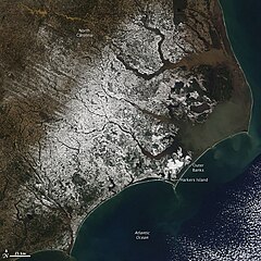
English: With miles of sandy beaches and generally good weather, coastal North Carolina isn’t a place you would usually expect to find snow. But the view from the Moderate Resolution Imaging Spectroradiometer (MODIS) on NASA’s Aqua satellite on February 14, 2010, shows snow extending to the Outer Banks. The sandy islands, normally pale tan, are bright white in this image. Harkers Island received 8.8 inches of snow, reported CNN. The snow fell in a winter storm that moved across the southern United States from Texas to the Atlantic Coast on February 12-13. |
| Dîrok | |
| Çavkanî | http://earthobservatory.nasa.gov/NaturalHazards/view.php?id=42698&src=nha |
| Xwedî | NASA |
| Guhartoyên din |
|

Lîsans[biguhêre]
| This file is in the public domain in the United States because it was solely created by NASA. NASA copyright policy states that "NASA material is not protected by copyright unless noted". (See Template:PD-USGov, NASA copyright policy page or JPL Image Use Policy.) | ||
 |
Warnings:
|
Dîroka daneyê
Ji bo dîtina guhartoya wê demê bişkoka dîrokê bitikîne.
| Dîrok/Katjimêr | Wêneyê biçûk | Mezinahî | Bikarhêner | Şirove | |
|---|---|---|---|---|---|
| niha | 19:42, 16 sibat 2010 | | 720 x 720 (455 KB) | Captain-tucker (gotûbêj | beşdarî) | {{Information |Description={{en|With miles of sandy beaches and generally good weather, coastal North Carolina isn’t a place you would usually expect to find snow. But the view from the Moderate Resolution Imaging Spectroradiometer (MODIS) on NASA’s A |
Tu nikarî cardin li ser vê dosyeyê binivîsînî.
Bikaranîna pelê
Zêdetirî 100 rûpelan vê pelê bi kar tînin. Lîsteya li jêr 100 rûpelên pêşîn ên ku tenê vê rûpelê bi kar tînin nîşan dide. Lîsteya temamê wan berdest e.
- North Carolina
- File:Snow in Coastal North Carolina 2010-02-14 lrg.jpg
- Category:1901 in North Carolina
- Category:1903 in North Carolina
- Category:1910 in North Carolina
- Category:1912 in North Carolina
- Category:1955 in North Carolina
- Category:1959 in North Carolina
- Category:1971 in North Carolina
- Category:1974 in North Carolina
- Category:1975 in North Carolina
- Category:1978 in North Carolina
- Category:1979 in North Carolina
- Category:1980 in North Carolina
- Category:1992 in North Carolina
- Category:1995 in North Carolina
- Category:1997 in North Carolina
- Category:1998 in North Carolina
- Category:1999 in North Carolina
- Category:2000 in North Carolina
- Category:2001 in North Carolina
- Category:2002 in North Carolina
- Category:2003 in North Carolina
- Category:2004 in North Carolina
- Category:2005 in North Carolina
- Category:2006 in North Carolina
- Category:2007 in North Carolina
- Category:2008 in North Carolina
- Category:2009 in North Carolina
- Category:2010 in North Carolina
- Category:2011 in North Carolina
- Category:2012 in North Carolina
- Category:Airports in North Carolina
- Category:Arboreta in North Carolina
- Category:Archaeological sites in North Carolina
- Category:Architecture of North Carolina
- Category:Association football venues in North Carolina
- Category:Basketball players from North Carolina
- Category:Beaches of North Carolina
- Category:Bodies of water in North Carolina
- Category:Botanical gardens in North Carolina
- Category:Bridges in North Carolina
- Category:Canals in North Carolina
- Category:Caves of North Carolina
- Category:Cemeteries in North Carolina
- Category:Cities in North Carolina
- Category:Dams in North Carolina
- Category:Education in North Carolina
- Category:Energy in North Carolina
- Category:Festivals in North Carolina
- Category:Flora of North Carolina
- Category:Forests in North Carolina
- Category:Fountains in North Carolina
- Category:Geology of North Carolina
- Category:Hospitals in North Carolina
- Category:Hotels in North Carolina
- Category:Islands of North Carolina
- Category:Lakes of North Carolina
- Category:Libraries in North Carolina
- Category:Lighthouses in North Carolina
- Category:Lighthouses on the National Register of Historic Places in North Carolina
- Category:Maps of North Carolina
- Category:National Historic Landmarks in North Carolina
- Category:North Carolina
- Category:North Carolina by decade
- Category:North Carolina by year
- Category:North Carolina in the 1860s
- Category:North Carolina in the 1870s
- Category:North Carolina in the 1880s
- Category:North Carolina in the 1890s
- Category:North Carolina in the 18th century
- Category:North Carolina in the 1900s
- Category:North Carolina in the 1910s
- Category:North Carolina in the 1920s
- Category:North Carolina in the 1930s
- Category:North Carolina in the 1940s
- Category:North Carolina in the 1950s
- Category:North Carolina in the 1960s
- Category:North Carolina in the 1970s
- Category:North Carolina in the 1980s
- Category:North Carolina in the 1990s
- Category:North Carolina in the 19th century
- Category:North Carolina in the 2000s
- Category:North Carolina in the 2010s
- Category:North Carolina in the 20th century
- Category:North Carolina in the 21st century
- Category:Nuclear power plants in North Carolina
- Category:Parks in North Carolina
- Category:Protected areas of North Carolina
- Category:Religion in North Carolina
- Category:Reservoirs in North Carolina
- Category:Rivers of North Carolina
- Category:Roads in North Carolina
- Category:Schools in North Carolina
- Category:Shopping malls in North Carolina
- Category:Streets in North Carolina
- Category:Towers in North Carolina
- Category:Towns in North Carolina
- Category:Unincorporated communities in North Carolina
- Category:Water transport in North Carolina
View more links to this file.
Bikaranîna gerdûnî ya pelê
Ev wîkiyên di rêzê de vê pelê bi kar tînin:
- Bikaranîna di ar.wikipedia.org de
- Bikaranîna di ary.wikipedia.org de
- Bikaranîna di arz.wikipedia.org de
- Bikaranîna di ast.wikipedia.org de
- Bikaranîna di ca.wikipedia.org de
- Bikaranîna di cy.wikipedia.org de
- Bikaranîna di dag.wikipedia.org de
- Bikaranîna di de.wikivoyage.org de
- Bikaranîna di diq.wikipedia.org de
- Bikaranîna di eo.wikipedia.org de
- Bikaranîna di eu.wikipedia.org de
- Bikaranîna di fr.wikinews.org de
- Bikaranîna di fr.wikivoyage.org de
- Bikaranîna di ga.wikipedia.org de
- Bikaranîna di gl.wikipedia.org de
- Bikaranîna di ha.wikipedia.org de
- Bikaranîna di he.wikipedia.org de
- Bikaranîna di ht.wikipedia.org de
- Bikaranîna di hy.wikipedia.org de
- Bikaranîna di ia.wikipedia.org de
- Bikaranîna di ig.wikipedia.org de
- Bikaranîna di ku.wikipedia.org de
- Bikaranîna di mhr.wikipedia.org de
- Bikaranîna di nn.wikipedia.org de
- Bikaranîna di oc.wikipedia.org de
- Bikaranîna di os.wikipedia.org de
- Bikaranîna di pap.wikipedia.org de
- Bikaranîna di pl.wikipedia.org de
- Bikaranîna di ru.wikinews.org de
- Bikaranîna di sr.wikipedia.org de
- Bikaranîna di tg.wikipedia.org de
- Bikaranîna di tl.wikipedia.org de
- Bikaranîna di tt.wikipedia.org de
- Bikaranîna di vec.wikipedia.org de
- Bikaranîna di vi.wikipedia.org de
- Bikaranîna di www.wikidata.org de