File:SoG 1.jpg
Jump to navigation
Jump to search

Size of this preview: 724 × 600 pixels. Other resolutions: 290 × 240 pixels | 580 × 480 pixels | 927 × 768 pixels | 1,106 × 916 pixels.
Original file (1,106 × 916 pixels, file size: 576 KB, MIME type: image/jpeg)
Captions
Captions
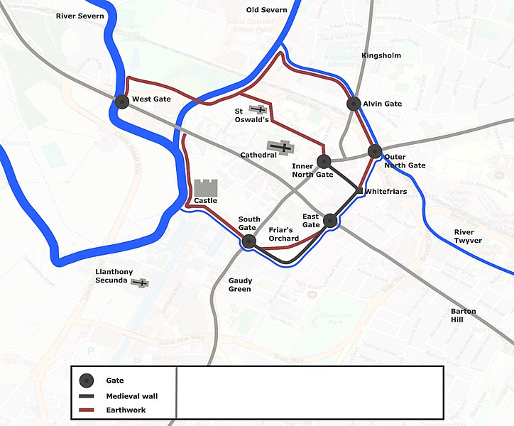
Defensive works during the Siege of Gloucester 1643
Summary[edit]
| Description |
English: Map of the medieval walls and defensive earthworks constructed during the Siege of Gloucester in 1643, superimposed on a map of modern-day Gloucester |
| Date | |
| Source | Own work Base map: Openstreetmap. Details: Day, Jon (2007). Gloucester and Newbury 1643: The Turning Point of the Civil War (E-Book). Barnsley, South Yorkshire: Pen & Sword Military. ISBN 978-1-84415-591-0. Course of the River Twyver: https://www.british-history.ac.uk/vch/glos/vol4/pp63-72 fig. 4 |
| Author | Factotem |
Licensing[edit]
I, the copyright holder of this work, hereby publish it under the following license:
This file is licensed under the Creative Commons Attribution-Share Alike 4.0 International license.
- You are free:
- to share – to copy, distribute and transmit the work
- to remix – to adapt the work
- Under the following conditions:
- attribution – You must give appropriate credit, provide a link to the license, and indicate if changes were made. You may do so in any reasonable manner, but not in any way that suggests the licensor endorses you or your use.
- share alike – If you remix, transform, or build upon the material, you must distribute your contributions under the same or compatible license as the original.
File history
Click on a date/time to view the file as it appeared at that time.
| Date/Time | Thumbnail | Dimensions | User | Comment | |
|---|---|---|---|---|---|
| current | 19:29, 11 April 2020 | | 1,106 × 916 (576 KB) | Factotem (talk | contribs) | Uploaded own work with UploadWizard |
You cannot overwrite this file.
File usage on Commons
There are no pages that use this file.
File usage on other wikis
The following other wikis use this file:
- Usage on en.wikipedia.org