File:Solor in 1602.jpg
Jump to navigation
Jump to search

Size of this preview: 800 × 335 pixels. Other resolutions: 320 × 134 pixels | 640 × 268 pixels | 1,024 × 429 pixels | 2,268 × 950 pixels.
Original file (2,268 × 950 pixels, file size: 849 KB, MIME type: image/jpeg)
Captions
Captions
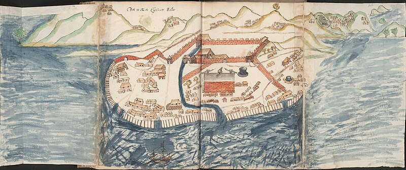
Dutch map of Solor made ca. 1602
Summary
[edit]
| Description |
English: Map of Solor, made during the journey of Wolfert Harmensz' fleet (1601-1603) |
| Date | |
| Source | https://www.nationaalarchief.nl/onderzoeken/archief/1.04.01/invnr/136/file/NL-HaNA_1.04.01_136_0001?eadID=1.04.01&unitID=136&query |
| Author | Joris Joostensz. Laerle (1603) |
Licensing
[edit]
|
This work is in the public domain in its country of origin and other countries and areas where the copyright term is the author's life plus 70 years or fewer. | |
| This file has been identified as being free of known restrictions under copyright law, including all related and neighboring rights. | |
File history
Click on a date/time to view the file as it appeared at that time.
| Date/Time | Thumbnail | Dimensions | User | Comment | |
|---|---|---|---|---|---|
| current | 17:36, 14 February 2024 | | 2,268 × 950 (849 KB) | Zapata1000 (talk | contribs) | Uploaded a work by Joris Joostensz. Laerle (1603) from https://www.nationaalarchief.nl/onderzoeken/archief/1.04.01/invnr/136/file/NL-HaNA_1.04.01_136_0001?eadID=1.04.01&unitID=136&query with UploadWizard |
You cannot overwrite this file.
File usage on Commons
There are no pages that use this file.