File:South America's longest balcony.jpg
Jump to navigation
Jump to search

Size of this preview: 800 × 349 pixels. Other resolutions: 320 × 139 pixels | 640 × 279 pixels | 1,024 × 446 pixels | 1,280 × 558 pixels | 2,762 × 1,204 pixels.
Original file (2,762 × 1,204 pixels, file size: 371 KB, MIME type: image/jpeg)
Captions
Captions
Add a one-line explanation of what this file represents
Summary
[edit]
| Description |
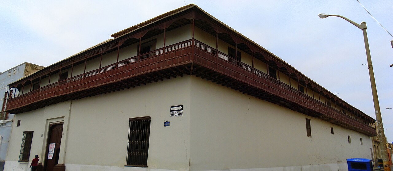
English: Also known as Casa de la Logia. Famous for its 67-meter-long balcony, which is said to be the longest of colonial age. It’s also said to be the longest in South America and the second longest in the world, though I’m not sure about those. This house (now an INEI office, from what I could see) is also famous for being the place where Peruvian Independence was first proclaimed. Lambayeque, Peru. Panorama stitched from 2 photos.
Español: Conocida también como Casa de la Logia. Famosa por su balcón de 67 metros de largo, del cual se dice es el más largo de la época colonial. También se dice que es el más largo de Sudamérica y el segundo del mundo, aunque no sé qué tan cierto será. Esta casa (ahora un local del INEI, por lo que pude ver) es famosa también por ser el primer lugar donde se proclamó la Independencia del Perú. Lambayeque, Perú. Panorama compuesto por 2 fotos. |
| Date | |
| Source | https://www.flickr.com/photos/miguelveraleon/2780177874/ |
| Author | Miguel Vera León |
| Camera location | | View this and other nearby images on: OpenStreetMap |
|---|
Licensing
[edit]
This file is licensed under the Creative Commons Attribution 2.0 Generic license.
- You are free:
- to share – to copy, distribute and transmit the work
- to remix – to adapt the work
- Under the following conditions:
- attribution – You must give appropriate credit, provide a link to the license, and indicate if changes were made. You may do so in any reasonable manner, but not in any way that suggests the licensor endorses you or your use.
| This image was originally posted to Flickr by Miguel Vera at https://flickr.com/photos/8150716@N04/2780177874. It was reviewed on 7 October 2020 by FlickreviewR 2 and was confirmed to be licensed under the terms of the cc-by-2.0. |
File history
Click on a date/time to view the file as it appeared at that time.
| Date/Time | Thumbnail | Dimensions | User | Comment | |
|---|---|---|---|---|---|
| current | 15:27, 7 October 2020 | | 2,762 × 1,204 (371 KB) | MiguelAlanCS (talk | contribs) | Uploaded a work by Miguel Vera León from https://www.flickr.com/photos/miguelveraleon/2780177874/ with UploadWizard |
You cannot overwrite this file.
File usage on Commons
The following page uses this file:
File usage on other wikis
The following other wikis use this file:
- Usage on www.wikidata.org