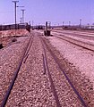
File:South Australian Railways dual-gauge centraliser, Gladstone (KNorgrove).jpg

Original file (796 × 911 pixels, file size: 297 KB, MIME type: image/jpeg)
Captions
Captions
Summary[edit]
| DescriptionSouth Australian Railways dual-gauge centraliser, Gladstone (KNorgrove).jpg |
English: South Australian Railways dual-gauge centraliser, Gladstone, South Australia. A fixed point centraliser to bring narrow gauge vehicles into a concentric position in broad gauge track: used to line up the end doors in sheep cars for transfer and to get the right clearance at the loading ramp seen in the background. In 1970, the line from Port Pirie to Broken Hill was opened after several years' engineering work to convert it to standard gauge, resulting in all three mainline gauges used in Australia – 1435 mm standard gauge, 1600 mm broad gauge, and 1067 mm narrow gauge – meeting in the railway yards at Gladstone. In the late 1980s, the broad and narrow gauge lines were closed, leaving Gladstone as standard gauge only. |
|||
| Date |
1970s date QS:P,+1970-00-00T00:00:00Z/8 |
|||
| Source | http://www.norgrove.me.uk/mg-track.htm | |||
| Author | Keith Norgrove | |||
| Permission (Reusing this file) |
|
|||
| Other versions |
|
| Camera location | 33° 16′ 12″ S, 138° 21′ 27″ E | View this and other nearby images on: OpenStreetMap |
|---|
Licensing[edit]
- You are free:
- to share – to copy, distribute and transmit the work
- to remix – to adapt the work
- Under the following conditions:
- attribution – You must give appropriate credit, provide a link to the license, and indicate if changes were made. You may do so in any reasonable manner, but not in any way that suggests the licensor endorses you or your use.
- share alike – If you remix, transform, or build upon the material, you must distribute your contributions under the same or compatible license as the original.
File history
Click on a date/time to view the file as it appeared at that time.
| Date/Time | Thumbnail | Dimensions | User | Comment | |
|---|---|---|---|---|---|
| current | 07:43, 27 October 2022 |  | 796 × 911 (297 KB) | SCHolar44 (talk | contribs) | Colour correction |
| 09:17, 22 November 2021 |  | 796 × 911 (737 KB) | SCHolar44 (talk | contribs) | Uploaded a work by Keith Norgrove from http://www.norgrove.me.uk/mg-track.htm with UploadWizard |
You cannot overwrite this file.
File usage on Commons
The following page uses this file:
File usage on other wikis
The following other wikis use this file:
- Usage on en.wikipedia.org
- Usage on id.wikipedia.org
- Usage on pt.wikipedia.org
Metadata
This file contains additional information such as Exif metadata which may have been added by the digital camera, scanner, or software program used to create or digitize it. If the file has been modified from its original state, some details such as the timestamp may not fully reflect those of the original file. The timestamp is only as accurate as the clock in the camera, and it may be completely wrong.
| Date and time of data generation | 13:12, 31 July 2021 |
|---|---|
| Horizontal resolution | 72 dpi |
| Vertical resolution | 72 dpi |
| Software used | Photos 3.0 |
| File change date and time | 13:12, 31 July 2021 |
| Date and time of digitizing | 13:12, 31 July 2021 |
| Color space | Uncalibrated |
| IIM version | 2 |
