File:South Island.jpg

原始文件 (2,618 × 2,926像素,文件大小:1.26 MB,MIME类型:image/jpeg)
说明
说明
摘要[编辑]
| 描述 |
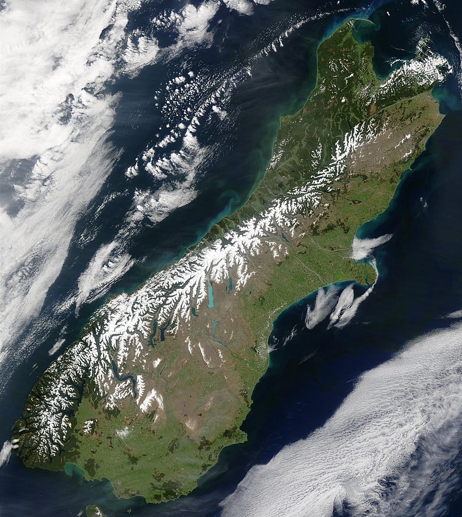
English: This true-color image provides a nearly cloud-free look at the South Island of New Zealand, from NASA’s Terra satellite.
Українська: Сніг виділяє гірські хребти Південних Альп (супутниковий знімок НАСА), Нова Зеландія. |
| 日期 | |
| 来源 | NASA's Earth Observatory |
| 作者 | Jacques Descloitres, MODIS Land Rapid Response Team at NASA GSFC |
| 授权 (二次使用本文件) |
Public domain - original work of NASA |
| 其他版本 | Image:South.island.arp.750pix.jpg is lower resolution, more tightly cropped |
This true-color image provides a nearly cloud-free look at the South Island of New Zealand. The scene was acquired by NASA’s Terra satellite, on October 23, 2002.
Forested areas are clearly indicated by the very dark green, particularly in the northwest and southwest. The braided Waimakariri and Rakaia rivers can also clearly be seen as they make their way to the east coast on either side of Banks Peninsula.
Image courtesy Jacques Descloitres, MODIS Land Rapid Response Team at NASA GSFC.
SOURCE: http://earthobservatory.nasa.gov/Newsroom/NewImages/images.php3?img_id=10881
”The purpose of NASA's Earth Observatory is to provide a freely-accessible publication on the Internet where the public can obtain new satellite imagery and scientific information about our home planet. The focus is on Earth's climate and environmental change. In particular, we hope our site is useful to public media and educators. Any and all materials published on the Earth Observatory are freely available for re-publication or re-use, except where copyright is indicated. We ask that NASA's Earth Observatory be given credit for its original materials.”
许可协议[编辑]
| 本文件完全由NASA创作,在美国属于公有领域。根据NASA的版权方针,NASA的材料除非另有声明否则不受版权保护。(参见Template:PD-USGov/zh、NASA版权方针页面或JPL图片使用方针。) | ||
 |
警告:
|
文件历史
点击某个日期/时间查看对应时刻的文件。
| 日期/时间 | 缩略图 | 大小 | 用户 | 备注 | |
|---|---|---|---|---|---|
| 当前 | 2006年5月18日 (四) 00:48 | | 2,618 × 2,926(1.26 MB) | Avenue(留言 | 贡献) | {{Information| |Description=This true-color image provides a nearly cloud-free look at the South Island of New Zealand, from NASA’s Terra satellite. |Source=[http://earthobservatory.nasa.gov/Newsroom/NewImages/images.php3?img_id=10881 NASA's Earth Obser |
您不可以覆盖此文件。
文件用途
没有页面使用本文件。
全域文件用途
以下其他wiki使用此文件:
- af.wikipedia.org上的用途
- ang.wikipedia.org上的用途
- an.wikipedia.org上的用途
- ar.wikipedia.org上的用途
- bh.wikipedia.org上的用途
- ceb.wikipedia.org上的用途
- cs.wikipedia.org上的用途
- da.wikipedia.org上的用途
- de.wikipedia.org上的用途
- de.wikivoyage.org上的用途
- el.wikipedia.org上的用途
- en.wikipedia.org上的用途
- en.wikiversity.org上的用途
- eo.wikipedia.org上的用途
- et.wikipedia.org上的用途
- fa.wikipedia.org上的用途
- fi.wikipedia.org上的用途
- fr.wikipedia.org上的用途
- gl.wikipedia.org上的用途
- he.wikipedia.org上的用途
- hi.wikipedia.org上的用途
- hr.wikipedia.org上的用途
- hu.wikipedia.org上的用途
- is.wikipedia.org上的用途
- it.wikipedia.org上的用途
- ja.wikipedia.org上的用途
- mi.wikipedia.org上的用途
- mk.wikipedia.org上的用途
- ml.wikipedia.org上的用途
- mn.wikipedia.org上的用途
- nl.wikipedia.org上的用途
- nn.wikipedia.org上的用途
- no.wikipedia.org上的用途
- oc.wikipedia.org上的用途
- pnb.wikipedia.org上的用途
- pt.wikipedia.org上的用途
- sh.wikipedia.org上的用途
- sk.wikipedia.org上的用途
- sl.wikipedia.org上的用途
- sr.wikipedia.org上的用途
- sv.wikipedia.org上的用途
- tpi.wikipedia.org上的用途
- tr.wikipedia.org上的用途
查看本文件的更多全域用途。