File:South Island Line and West Island Line proposal.svg
跳至導覽
跳至搜尋

此 SVG 檔案的 PNG 預覽的大小:800 × 547 像素。 其他解析度:320 × 219 像素 | 640 × 438 像素 | 1,024 × 701 像素 | 1,280 × 876 像素 | 2,560 × 1,752 像素 | 1,140 × 780 像素。
原始檔案 (SVG 檔案,表面大小:1,140 × 780 像素,檔案大小:11 KB)
說明
說明
添加單行說明來描述出檔案所代表的內容
| 描述 |
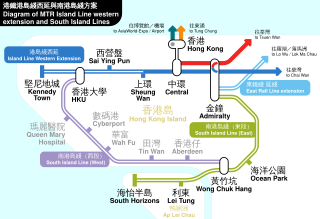
English: 2008 modified Hong Kong MTR West Island Line and South Island Line proposal.
中文:2008年修正後的南港島綫與西港島綫路線圖。 |
||
| 日期 | |||
| 來源 | 自己的作品 | ||
| 作者 | user:Sameboat | ||
| 授權許可 (重用此檔案) |
|
||
| 其他版本 | Image:WIL-SIL-Proposal-4 Chi 2.png, Image:WIL-SIL-Proposal-5.png |
Please do not replace the simplified code of this file with a version created with Inkscape or any other vector graphics editor
檔案歷史
點選日期/時間以檢視該時間的檔案版本。
| 日期/時間 | 縮圖 | 尺寸 | 使用者 | 備註 | |
|---|---|---|---|---|---|
| 目前 | 2018年7月15日 (日) 15:00 | | 1,140 × 780(11 KB) | Sameboat(留言 | 貢獻) | doctype |
| 2018年5月26日 (六) 00:04 |  | 1,140 × 780(11 KB) | Sameboat(留言 | 貢獻) | East Rail Line extension | |
| 2016年12月29日 (四) 06:45 |  | 1,140 × 780(11 KB) | Sameboat(留言 | 貢獻) | minor color change and + location labels | |
| 2016年12月29日 (四) 02:26 |  | 1,140 × 780(11 KB) | Sameboat(留言 | 貢獻) | typo: Aiport -> Airport | |
| 2016年12月28日 (三) 05:04 |  | 1,140 × 780(10 KB) | Sameboat(留言 | 貢獻) | ||
| 2016年5月23日 (一) 06:18 |  | 760 × 520(9 KB) | Sameboat(留言 | 貢獻) | 西港島綫 West Island Line -> 港島綫西延 Island Line western extension | |
| 2015年1月24日 (六) 01:26 |  | 760 × 470(9 KB) | Sameboat(留言 | 貢獻) | minor | |
| 2014年9月19日 (五) 06:51 |  | 760 × 470(9 KB) | Sameboat(留言 | 貢獻) | minor | |
| 2014年9月19日 (五) 06:49 |  | 760 × 470(9 KB) | Sameboat(留言 | 貢獻) | minor | |
| 2014年9月18日 (四) 13:59 |  | 760 × 470(9 KB) | Sameboat(留言 | 貢獻) | minor |
無法覆蓋此檔案。
檔案用途
下列26個頁面有用到此檔案:
- MTR Hong Kong
- User:Chumwa/OgreBot/Potential transport maps/2016 December 21-31
- User:Chumwa/OgreBot/Potential transport maps/2016 May 21-31
- User:Chumwa/OgreBot/Potential transport maps/2018 July 11-20
- User:Chumwa/OgreBot/Potential transport maps/2018 May 21-31
- User:Chumwa/OgreBot/Public transport information/2016 December 21-31
- User:Chumwa/OgreBot/Public transport information/2016 May 21-31
- User:Chumwa/OgreBot/Public transport information/2018 July 11-20
- User:Chumwa/OgreBot/Public transport information/2018 May 21-31
- User:Chumwa/OgreBot/Transport Maps/2016 December 21-31
- User:Chumwa/OgreBot/Transport Maps/2016 May 21-31
- User:Chumwa/OgreBot/Transport Maps/2018 July 11-20
- User:Chumwa/OgreBot/Transport Maps/2018 May 21-31
- User:Chumwa/OgreBot/Travel and communication maps/2016 December 21-31
- User:Chumwa/OgreBot/Travel and communication maps/2016 May 21-31
- User:Chumwa/OgreBot/Travel and communication maps/2018 July 11-20
- User:Chumwa/OgreBot/Travel and communication maps/2018 May 21-31
- User:OgreBot/Watercraft/2016 December 29
- User:OgreBot/Watercraft/2016 May 22-26
- User:OgreBot/Watercraft/2018 July 15
- User:OgreBot/Watercraft/2018 May 26
- User:Sameboat
- Commons:Graphic Lab School/Images to improve/Archive/Jun 2008
- File:WIL-SIL-Proposal-4 20080131.svg (檔案重新導向)
- Category:West Island Line
全域檔案使用狀況
以下其他 wiki 使用了這個檔案:
- en.wikipedia.org 的使用狀況
- ja.wikipedia.org 的使用狀況
- ko.wikipedia.org 的使用狀況
- nl.wikipedia.org 的使用狀況
- www.wikidata.org 的使用狀況
- zh-yue.wikipedia.org 的使用狀況
- zh.wikipedia.org 的使用狀況