File:South Tarawa (map within Tarawa Atoll).png
Jump to navigation
Jump to search
No higher resolution available.
South_Tarawa_(map_within_Tarawa_Atoll).png (600 × 600 pixels, file size: 62 KB, MIME type: image/png)
Captions
Captions
Add a one-line explanation of what this file represents

|
File:South Tarawa (separated to north and south).svg is a vector version of this file. It should be used in place of this PNG file when not inferior.
File:South Tarawa (map within Tarawa Atoll).png → File:South Tarawa (separated to north and south).svg
For more information, see Help:SVG. |
.svg) |
Summary[edit]
| Description |
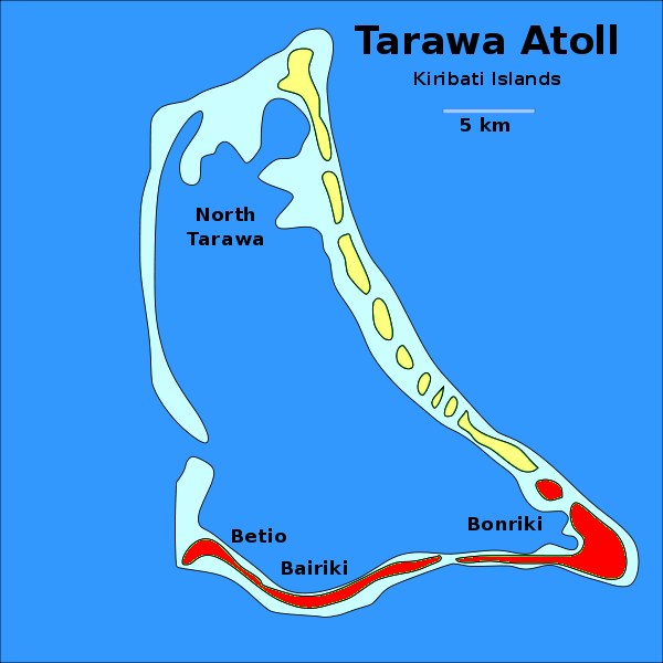
English: Locator map of the municipality of South Tarawa (shown in red) within the atoll of Tarawa, in Kiribati. The other municipality, North Tarawa, is shown in yellow. |
| Date | |
| Source | Derived work from the File:Tarawa Atoll, Kiribati.svg, uploaded by Indolences |
| Author | Dэя-Бøяg |
| Other versions |
|


_-_bel.svg)
.png&action=edit§ion=1)
Licensing[edit]
.png&action=edit§ion=2)
I, the copyright holder of this work, hereby publish it under the following licenses:

|
Permission is granted to copy, distribute and/or modify this document under the terms of the GNU Free Documentation License, Version 1.2 or any later version published by the Free Software Foundation; with no Invariant Sections, no Front-Cover Texts, and no Back-Cover Texts. A copy of the license is included in the section entitled GNU Free Documentation License. |
| This file is licensed under the Creative Commons Attribution-Share Alike 3.0 Unported license. | ||
| ||
| This licensing tag was added to this file as part of the GFDL licensing update. |
This file is licensed under the Creative Commons Attribution-Share Alike 2.5 Generic, 2.0 Generic and 1.0 Generic license.
- You are free:
- to share – to copy, distribute and transmit the work
- to remix – to adapt the work
- Under the following conditions:
- attribution – You must give appropriate credit, provide a link to the license, and indicate if changes were made. You may do so in any reasonable manner, but not in any way that suggests the licensor endorses you or your use.
- share alike – If you remix, transform, or build upon the material, you must distribute your contributions under the same or compatible license as the original.
You may select the license of your choice.
File history
Click on a date/time to view the file as it appeared at that time.
| Date/Time | Thumbnail | Dimensions | User | Comment | |
|---|---|---|---|---|---|
| current | 02:14, 28 November 2011 | | 600 × 600 (62 KB) | DerBorg (talk | contribs) | typo (Bairiki, not Bariki) |
| 21:02, 27 November 2011 |  | 600 × 600 (62 KB) | DerBorg (talk | contribs) | {{Information |Description= {{en|Locator map of the municipality of '''South Tarawa''' (shown in red) within the atoll of Tarawa, in Kiribati. The other municipality, North Tarawa, |
You cannot overwrite this file.
File usage on Commons
The following 5 pages use this file:
File usage on other wikis
The following other wikis use this file:
- Usage on ar.wikipedia.org
- Usage on arz.wikipedia.org
- Usage on bn.wikipedia.org
- Usage on ca.wikipedia.org
- Usage on ceb.wikipedia.org
- Usage on en.wikiversity.org
- Usage on eo.wikipedia.org
- Usage on es.wikipedia.org
- Usage on et.wikipedia.org
- Usage on eu.wikipedia.org
- Usage on fa.wikipedia.org
- Usage on fi.wikipedia.org
- Usage on gl.wikipedia.org
- Usage on ha.wikipedia.org
- Usage on hu.wikipedia.org
- Usage on hy.wikipedia.org
- Usage on io.wikipedia.org
- Usage on ka.wikipedia.org
- Usage on kk.wikipedia.org
- Usage on mt.wikipedia.org
- Usage on ne.wikipedia.org
- Usage on nl.wikipedia.org
- Usage on pa.wikipedia.org
- Usage on ro.wikipedia.org
- Usage on ru.wikipedia.org
- Usage on simple.wikipedia.org
- Usage on ta.wikipedia.org
- Usage on test.wikidata.org
- Usage on tg.wikipedia.org
- Usage on th.wikipedia.org
- Usage on uk.wikipedia.org
- Usage on www.wikidata.org
- Usage on xmf.wikipedia.org
- Usage on zh.wikipedia.org
.png&oldid=737070796)