File:Southern British Isles 9th century.svg
Jump to navigation
Jump to search

Size of this PNG preview of this SVG file: 629 × 435 pixels. Other resolutions: 320 × 221 pixels | 640 × 443 pixels | 1,024 × 708 pixels | 1,280 × 885 pixels | 2,560 × 1,770 pixels.
Original file (SVG file, nominally 629 × 435 pixels, file size: 1.95 MB)
Captions
Captions
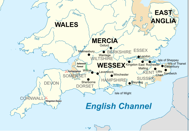
Map of the Southern British Isles during the 9th century
| Description |
English: Map of the Southern British Isles during the 9th century |
| Date | |
| Source | Own work Incorporates elements of this map. Locations are based on the Ordinance Survey Atlas of Great Britain, apart from Selwood Forest, which is taken from Barbara Yorke, Wessex in the Early Middle Ages, 1995, p. 23, ISBN 0 7185 1856 X |
| Author | Philg88; Attribution: Wikimedia Foundation (www.wikimedia.org) |
| Permission (Reusing this file) |
W3C-validity not checked. This W3C-unspecified vector image was created with Adobe Illustrator. This file is licensed under the Creative Commons Attribution 4.0 International license.
|
File history
Click on a date/time to view the file as it appeared at that time.
| Date/Time | Thumbnail | Dimensions | User | Comment | |
|---|---|---|---|---|---|
| current | 17:30, 19 July 2015 | | 629 × 435 (1.95 MB) | Philg88 (talk | contribs) | User requested modifications |
| 16:00, 19 July 2015 |  | 629 × 435 (1.65 MB) | Philg88 (talk | contribs) | {{Information |Description ={{en|1=Map of the Southern British Isles during the 9th century}} |Source ={{own}} Incorporates elements of [https://commons.wikimedia.org/wiki/File:British_Isles_10th_century.svg this map] |Author =[[User... |
You cannot overwrite this file.
File usage on Commons
There are no pages that use this file.
File usage on other wikis
The following other wikis use this file:
- Usage on bn.wikipedia.org
- Usage on br.wikipedia.org
- Usage on cs.wikipedia.org
- Usage on el.wikipedia.org
- Usage on en.wikipedia.org
- Usage on es.wikipedia.org
- Usage on fa.wikipedia.org
- Usage on he.wikipedia.org
- Usage on ja.wikipedia.org
- Usage on ko.wikipedia.org
- Usage on ms.wikipedia.org
- Usage on sk.wikipedia.org
- Usage on th.wikipedia.org
- Usage on tr.wikipedia.org
- Usage on zh.wikipedia.org