File:Southern Nevada 2A Region Map.png
Jump to navigation
Jump to search

Size of this preview: 447 × 600 pixels. Other resolutions: 179 × 240 pixels | 577 × 774 pixels.
Original file (577 × 774 pixels, file size: 44 KB, MIME type: image/png)
Captions
Captions
Add a one-line explanation of what this file represents
Summary
[edit]
| Description |
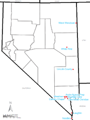
English: Southern Nevada 2A Region league map, with school locations placed on a map available courtesy of the U.S. Census. |
| Source | http://www2.census.gov/geo/maps/general_ref/stco_outline/cen2k_pgsz/stco_NV.pdf |
| Author | Frank12 (talk) 04:34, 15 February 2012 (UTC) |
Licensing
[edit]
This image or file is a work of a United States Census Bureau employee, taken or made as part of that person's official duties. As a work of the U.S. federal government, the image is in the public domain.
|
 |
Original upload log
[edit]
The original description page was here. All following user names refer to en.wikipedia.
| Date/Time | Dimensions | User | Comment |
|---|---|---|---|
| 2012-02-15 04:34 | 577×774× (45128 bytes) | Frank12 | {{Information |Description = Southern Nevada 2A Region league map, with school locations placed on a map available courtesy of the U.S. Census. |Source = http://www2.census.gov/geo/maps/general_ref/stco_outline/cen2k_pgsz/stco_NV.pdf |Date |
File history
Click on a date/time to view the file as it appeared at that time.
| Date/Time | Thumbnail | Dimensions | User | Comment | |
|---|---|---|---|---|---|
| current | 04:13, 25 April 2016 | | 577 × 774 (44 KB) | FastilyClone (talk | contribs) | Transferred from enwp |
You cannot overwrite this file.
File usage on Commons
There are no pages that use this file.
File usage on other wikis
The following other wikis use this file:
- Usage on en.wikipedia.org