File:Southindia1721.jpg
Original file (576 × 768 pixels, file size: 101 KB, MIME type: image/jpeg)
Captions
Captions
Summary
[edit]
| Description |
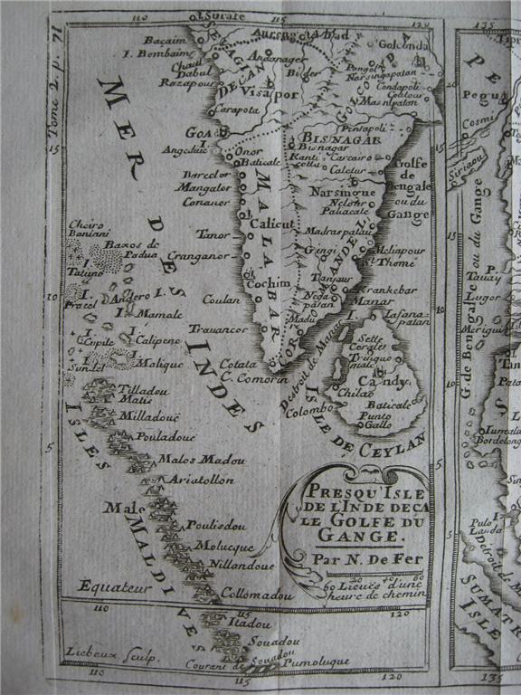
English: "Mogol," by Nicholas de Fer and J. Robbe, from 'Methode pour apprende facilement la geographie', Paris, 1721: *the whole map*: *northwest*; *northeast*; *southwest*; *southeast* (shown above); *a large, uncolored scan of the whole map*
Other maps from the same atlas:
PONDICHERRY, 1705 "Plan de Pondichery," by Nicholas de Fer, Paris, 1705 |
| Date | |
| Source | http://www.columbia.edu/itc/mealac/pritchett/00maplinks/mughal/defermaps/defermaps.html#pondicherry1705 |
| Author | Nicholas de Fer and J. Robbe |
Licensing
[edit]
|
This work is in the public domain in its country of origin and other countries and areas where the copyright term is the author's life plus 70 years or fewer.
| |
| This file has been identified as being free of known restrictions under copyright law, including all related and neighboring rights. | |
File history
Click on a date/time to view the file as it appeared at that time.
| Date/Time | Thumbnail | Dimensions | User | Comment | |
|---|---|---|---|---|---|
| current | 01:20, 4 November 2022 | | 576 × 768 (101 KB) | Baddu676 (talk | contribs) | Uploaded a work by Nicholas de Fer and J. Robbe from http://www.columbia.edu/itc/mealac/pritchett/00maplinks/mughal/defermaps/defermaps.html#pondicherry1705 with UploadWizard |
You cannot overwrite this file.
File usage on Commons
There are no pages that use this file.