File:Soviet Caucasus map.svg
跳至導覽
跳至搜尋

此 SVG 檔案的 PNG 預覽的大小:712 × 600 像素。 其他解析度:285 × 240 像素 | 570 × 480 像素 | 912 × 768 像素 | 1,216 × 1,024 像素 | 2,432 × 2,048 像素 | 747 × 629 像素。
原始檔案 (SVG 檔案,表面大小:747 × 629 像素,檔案大小:731 KB)
說明
說明
添加單行說明來描述出檔案所代表的內容
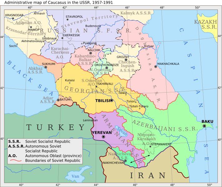
Administrative Map of the Caucasus in the USSR, 1957-1991
摘要
[編輯]
| 描述 |
English: Administrative map of Caucasus in USSR, 1957-1991 |
| 日期 | (UTC) |
| 來源 | |
| 作者 |
|
| 其他版本 |
 |
| 這是一張修飾過的圖片,即本圖片是用軟體修改過後的版本,修改的方式或內容有:Vectorization。原版圖片來源:Caucasiamapussr.gif。修改者:Hellerick。
|
授權條款
[編輯]
我,本作品的著作權持有者,決定用以下授權條款發佈本作品:
| 此檔案採用共享創意 姓名標示-相同方式分享 3.0 未在地化版本授權條款。 | ||
| ||
| 已新增授權條款標題至此檔案,作為GFDL授權更新的一部份。 |

|
已授權您依據自由軟體基金會發行的無固定段落、封面文字和封底文字GNU自由文件授權條款1.2版或任意後續版本,對本檔進行複製、傳播和/或修改。該協議的副本列在GNU自由文件授權條款中。 |
您可以選擇您需要的授權條款。
原始上傳日誌
[編輯]
This image is a derivative work of the following images:
- File:Caucasiamapussr.gif licensed with Cc-by-sa-3.0-migrated, GFDL
- 2011-03-27T04:49:14Z Hellerick 700x590 (82529 Bytes) The earlier changes were correct.
- 2011-01-16T19:12:39Z Geagea 700x590 (60613 Bytes) Reverted to version as of 10:16, 24 February 2007. To the uploader's last version
- 2011-01-16T18:38:27Z Nicolay Sidorov 700x590 (82529 Bytes) Adygea to Krasnodar, Karachay-Cherkess to Stavropol.
- 2011-01-16T18:31:42Z Nicolay Sidorov 700x590 (82116 Bytes) The Chechen-Ingush republic was restored on January 9, 1957
- 2007-02-24T10:16:08Z Hardscarf 700x590 (60613 Bytes) {{Information |Description=Administrative map of [[:en:Caucasus]] in USSR, 1952-1991 |Source=Armenica.org {{ConfirmationImageOTRS|source=http://armenica.org/|otrs=2007010210006387}} Originally from [http://en.wikipedia.org en
Uploaded with derivativeFX
檔案歷史
點選日期/時間以檢視該時間的檔案版本。
| 日期/時間 | 縮圖 | 尺寸 | 用戶 | 備註 | |
|---|---|---|---|---|---|
| 目前 | 2017年6月14日 (三) 09:37 | | 747 × 629(731 KB) | Hellerick(對話 | 貢獻) | moved Grozny; replaced Prokhladni with Pyatigorsk |
| 2011年3月29日 (二) 11:08 |  | 700 × 590(701 KB) | Hellerick(對話 | 貢獻) | Still fixing font bug | |
| 2011年3月29日 (二) 11:05 |  | 700 × 590(682 KB) | Hellerick(對話 | 貢獻) | Still fixng font bug | |
| 2011年3月29日 (二) 11:02 |  | 700 × 590(589 KB) | Hellerick(對話 | 貢獻) | Fixed font bug | |
| 2011年3月29日 (二) 10:57 |  | 700 × 590(152 KB) | Hellerick(對話 | 貢獻) | Fexed external link bug | |
| 2011年3月29日 (二) 10:56 |  | 700 × 590(181 KB) | Hellerick(對話 | 貢獻) | {{Information |Description=Administrative map of en:Caucasus in USSR, 1957-1991 |Source=*File:Caucasiamapussr.gif |Date=2011-03-29 10:53 (UTC) |Author=*File:Caucasiamapussr.gif: Original uploader was Artaxiad at [htt |
無法覆蓋此檔案。
檔案用途
下列5個頁面有用到此檔案:
全域檔案使用狀況
以下其他 wiki 使用了這個檔案:
- ar.wikipedia.org 的使用狀況
- ast.wikipedia.org 的使用狀況
- azb.wikipedia.org 的使用狀況
- az.wikipedia.org 的使用狀況
- be.wikipedia.org 的使用狀況
- bg.wikipedia.org 的使用狀況
- bn.wikipedia.org 的使用狀況
- bs.wikipedia.org 的使用狀況
- ca.wikipedia.org 的使用狀況
- ce.wikipedia.org 的使用狀況
- ckb.wikipedia.org 的使用狀況
- cs.wikipedia.org 的使用狀況
檢視此檔案的更多全域使用狀況。
詮釋資料
分類:
- Maps of the Armenian Soviet Socialist Republic
- Maps of the Azerbaijan Soviet Socialist Republic
- Maps of the Georgian Soviet Socialist Republic
- Maps of the Russian Soviet Federative Socialist Republic
- Maps of the Transcaucasian Socialist Federative Soviet Republic
- Maps of the history of Abkhazia
- Maps of the history of Adygea
- Maps of the history of Ajaria
- Maps of the history of Armenia
- Maps of the history of the Caucasus under Soviet rule
- Maps of the history of Chechnya
- Maps of the history of Dagestan
- Maps of the history of Georgia
- English-language SVG maps showing history