File:Soviet Navy Bases 1984.png
Skočit na navigaci
Skočit na vyhledávání
Velikost tohoto náhledu: 800 × 370 pixelů. Jiná rozlišení: 320 × 148 pixelů | 640 × 296 pixelů | 1 357 × 628 pixelů.
Původní soubor (1 357 × 628 pixelů, velikost souboru: 41 KB, MIME typ: image/png)
Popisky
Popisky
Přidejte jednořádkové vysvětlení, co tento soubor představuje
| Popis |
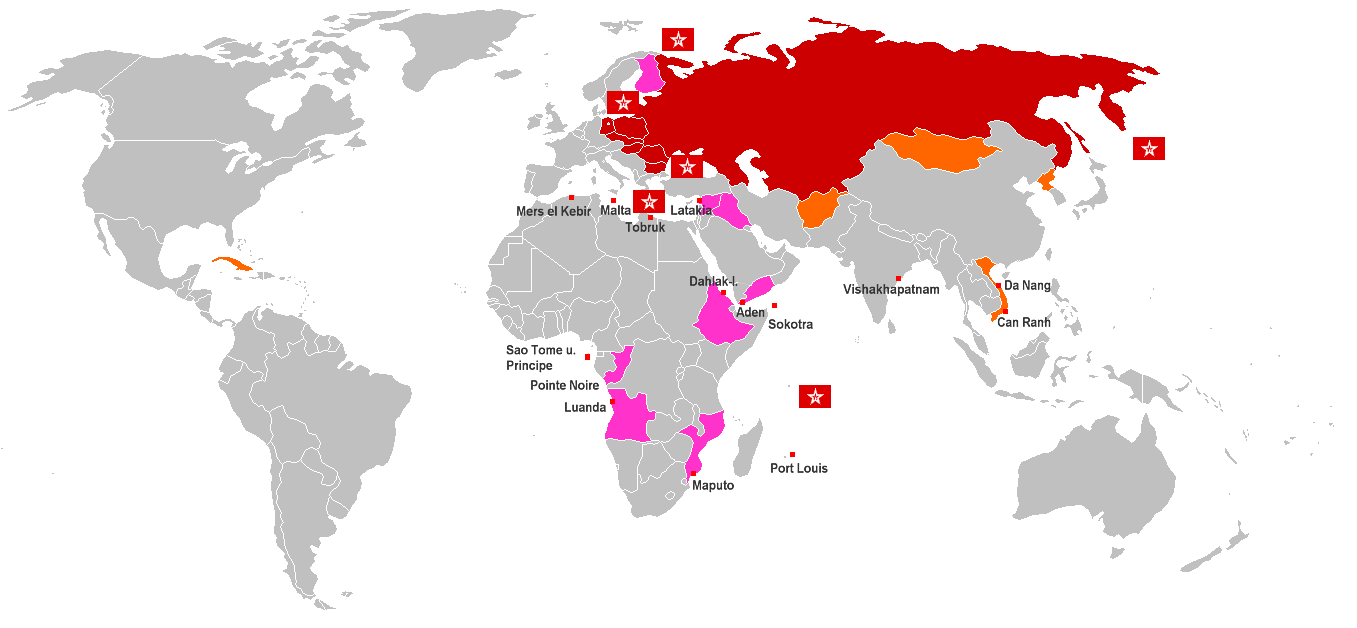
English: World Map of Soviet Navy Bases and anchor rights (red cubes with name). Red countries are Warsaw Pact member states, Orange countries are States with special treaty of mutual assistance and friendship with the Soviet Union, Pink countries are States with special treaty of mutual assistance and friendship since 1970, Flags are Fleets of the Soviet Navy Deutsch: Weltkarte der sowjetischen Marinebasen und Ankerrechte (roter Würfel). Rot eingefärbte Länder sind Warschauer Pakt-Staaten, orange eingefärbte sind Staaten mit einem Freundschafts- und Beistandsabkommen mit besonderer Bindung zur Sowjetunion, rosa eingefärbte Länder sind Staaten mit sonstige Freundschafts- und Beistandsabkommen, bzw. Militärhilfeabkommen ab 1970, Gösch-Flaggen sind Flotten und Detachements der Sowjetischen Marine (Nordmeerflotte, Baltische Flotte, Schwarzmeer-Flotte, Pazifikflotte und Detachements im Mittelmeer (Eskadra) und im Indischen Ozean |
| Datum | |
| Zdroj | Vlastní dílo |
| Autor | Wikifreund, Germany |
| Svolení (Užití tohoto souboru) |
Tento soubor podléhá licenci Creative Commons Uveďte autora 2.0 Generic
|
Historie souboru
Kliknutím na datum a čas se zobrazí tehdejší verze souboru.
| Datum a čas | Náhled | Rozměry | Uživatel | Komentář | |
|---|---|---|---|---|---|
| současná | 17. 2. 2009, 02:05 | | 1 357 × 628 (41 KB) | Disposable.Heroes (diskuse | příspěvky) | pngcrush |
| 10. 10. 2008, 21:08 |  | 1 357 × 628 (55 KB) | Milosevo (diskuse | příspěvky) | {{Information |Description= |Source= |Date= |Author= |Permission= |other_versions= }} | |
| 25. 7. 2007, 11:05 |  | 1 357 × 628 (46 KB) | Wikifreund (diskuse | příspěvky) | {{Information |Description={{en|World Map of Soviet Navy Bases and anchor rights (= red cubes with name). Red countries = Warsaw Pact member states, Orange countries = States with special treaty of mutual assistance and friendship with the Soviet Union, P |
Tento soubor nemůžete přepsat.
Využití souboru
Na tento soubor neodkazuje na Commons žádná stránka.
Globální využití souboru
Tento soubor využívají následující wiki:
- Využití na ba.wikipedia.org
- Využití na be-tarask.wikipedia.org
- Využití na be.wikipedia.org
- Využití na bg.wikipedia.org
- Využití na ca.wikipedia.org
- Využití na cs.wikipedia.org
- Využití na da.wikipedia.org
- Využití na de.wikipedia.org
- Využití na en.wikipedia.org
- Využití na es.wikipedia.org
- Využití na fi.wikipedia.org
- Využití na fr.wikipedia.org
- Využití na it.wikipedia.org
- Využití na ja.wikipedia.org
- Využití na ko.wikipedia.org
- Využití na ru.wikipedia.org
- Využití na tr.wikipedia.org
- Využití na uk.wikipedia.org
- Využití na www.wikidata.org
- Využití na zh.wikipedia.org