File:SpaceX Boca Chica launch site.jpg
Jump to navigation
Jump to search

Size of this preview: 800 × 583 pixels. Other resolutions: 320 × 233 pixels | 640 × 467 pixels | 1,024 × 746 pixels | 1,236 × 901 pixels.
Original file (1,236 × 901 pixels, file size: 654 KB, MIME type: image/jpeg)
Captions
Captions
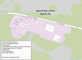
A launch site map as of September 2020.

|
File:SpaceX South Texas Launch Site.svg is a vector version of this file. It should be used in place of this JPG file when not inferior.
File:SpaceX Boca Chica launch site.jpg → File:SpaceX South Texas Launch Site.svg
For more information, see Help:SVG. |
 |
Summary
[edit]
| Description |
English: A launch site map as of September 2020. |
| Date | |
| Source | openstreetmap.org |
| Author |
© OpenStreetMap-contributors Base map is from OpenStreetMap. Modifications are my own work. |
This map was created on the basis of the OpenStreetMap project data, collected by the community. OpenStreetMap data is available under the Open Database License (details). Map tiles are licensed under the Creative Commons Attribution-ShareAlike 2.0 license (CC-BY-SA 2.0). https://www.openstreetmap.org/copyright
Licensing
[edit]
This file is licensed under the Creative Commons Attribution-Share Alike 4.0 International license.
- You are free:
- to share – to copy, distribute and transmit the work
- to remix – to adapt the work
- Under the following conditions:
- attribution – You must give appropriate credit, provide a link to the license, and indicate if changes were made. You may do so in any reasonable manner, but not in any way that suggests the licensor endorses you or your use.
- share alike – If you remix, transform, or build upon the material, you must distribute your contributions under the same or compatible license as the original.
File history
Click on a date/time to view the file as it appeared at that time.
| Date/Time | Thumbnail | Dimensions | User | Comment | |
|---|---|---|---|---|---|
| current | 20:36, 19 September 2020 | | 1,236 × 901 (654 KB) | David162se (talk | contribs) | Uploaded a work by © OpenStreetMap-contributors Base map is from OpenStreetMap. Modifications are my own work. from openstreetmap.org with UploadWizard |
You cannot overwrite this file.
File usage on Commons
There are no pages that use this file.
File usage on other wikis
The following other wikis use this file:
- Usage on ar.wikipedia.org
- Usage on cs.wikipedia.org
- Usage on fr.wikipedia.org
- Usage on hu.wikipedia.org
- Usage on id.wikipedia.org
- Usage on uk.wikipedia.org
- Usage on zh.wikipedia.org