File:Spanish Empire Anachronous en.svg
跳至導覽
跳至搜尋

此 SVG 檔案的 PNG 預覽的大小:800 × 407 像素。 其他解析度:320 × 163 像素 | 640 × 325 像素 | 1,024 × 520 像素 | 1,280 × 650 像素 | 2,560 × 1,301 像素 | 2,753 × 1,399 像素。
原始檔案 (SVG 檔案,表面大小:2,753 × 1,399 像素,檔案大小:1.12 MB)
說明
說明
添加單行說明來描述出檔案所代表的內容
摘要
[編輯]
| 描述 |
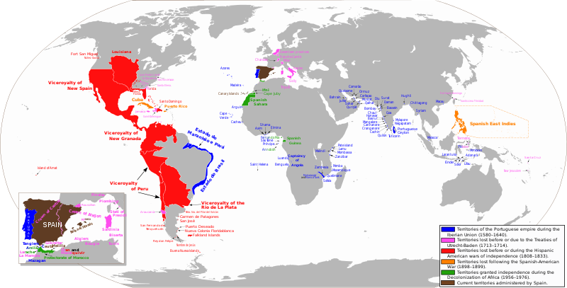
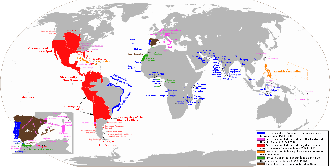
Español: Mapa diacrónico de los territorios del Imperio Español
Territorios del imperio portugués durante la Unión Ibérica (1580-1640)
Territorios hasta los Tratados de Utrecht-Baden (1713–1714)
Territorios hasta las Guerras de independencia hispanoamericana (1808–1833)
Territorios hasta la Guerra Hispano-Estadounidense (1898-1899)
Territorios hasta la Descolonización de África (1956-1976)
Territorios actualmente administrados por España English: Anachronous map of the Spanish Empire
Territories of the Portuguese empire during the Iberian Union (1580-1640)
Territories until the Treaties of Utrecht-Baden (1713–1714)
Territories until the Spanish American wars of independence (1808–1833)
Territories until the Spanish-American War (1898-1899)
Territories granted independence during the Decolonization of Africa (1956-1976)
Current territories administered by Spain |
| 日期 | |
| 來源 | 自己的作品. View sources in talk page |
| 作者 | Trasamundo |
| 授權許可 (重用此檔案) |
trabajo propio (own work) |
| 其他版本 |
 |
授權條款
[編輯]
我,本作品的著作權持有者,決定用以下授權條款發佈本作品:

|
已授權您依據自由軟體基金會發行的無固定段落、封面文字和封底文字GNU自由文件授權條款1.2版或任意後續版本,對本檔進行複製、傳播和/或修改。該協議的副本列在GNU自由文件授權條款中。 |
您可以選擇您需要的授權條款。
檔案歷史
點選日期/時間以檢視該時間的檔案版本。
| 日期/時間 | 縮圖 | 尺寸 | 用戶 | 備註 | |
|---|---|---|---|---|---|
| 目前 | 2023年5月1日 (一) 02:15 | | 2,753 × 1,399(1.12 MB) | Janitoalevic(對話 | 貢獻) | Fixed borders and added Araucanía |
| 2023年4月24日 (一) 08:57 |  | 2,753 × 1,399(1.01 MB) | Durero(對話 | 貢獻) | Araucanía lost after mapuche rebelions. Restored previous version beacuse of borders | |
| 2023年2月13日 (一) 16:05 |  | 2,753 × 1,399(1.12 MB) | Janitoalevic(對話 | 貢獻) | Added border between Chile and Perú, full Esequibo territory, Buena Nueva Islands and San Fernando de Tenquehuén. | |
| 2019年11月27日 (三) 19:25 |  | 2,753 × 1,399(1.01 MB) | FDRMRZUSA(對話 | 貢獻) | Corrected error (Siena) for "great" map too. In previous update the correction was restricted to the "little" map (box) on the lower left. No other changes. | |
| 2019年11月27日 (三) 19:00 |  | 2,753 × 1,399(1.01 MB) | FDRMRZUSA(對話 | 貢獻) | Restored version of 9 June 2013 (latest updated version) but with corrected mistake: Siena was part of the Granduchy of Tuscany. No other changes. | |
| 2019年11月15日 (五) 18:31 |  | 2,753 × 1,400(1.37 MB) | Barjimoa(對話 | 貢獻) | Reverted to version as of 18:53, 29 March 2009 (UTC) Correcting mistake: Siena was part of the Granduchy of Tuscany. | |
| 2013年6月9日 (日) 21:21 |  | 2,753 × 1,399(1.33 MB) | Trasamundo(對話 | 貢獻) | Oceanía | |
| 2013年1月28日 (一) 19:27 |  | 2,753 × 1,400(1.53 MB) | Trasamundo(對話 | 貢獻) | dates | |
| 2012年9月6日 (四) 19:51 |  | 2,753 × 1,400(1.49 MB) | Trasamundo(對話 | 貢獻) | Iberian Peninsula | |
| 2011年3月29日 (二) 21:27 |  | 2,753 × 1,400(1.52 MB) | Trasamundo(對話 | 貢獻) | North Amarica: fixing the geographical accuracy, missions, forts |
無法覆蓋此檔案。
檔案用途
下列9個頁面有用到此檔案:
- Atlas of colonialism
- Império Português
- User:Magog the Ogre/Multilingual legend/2023 April 21-30
- User:Magog the Ogre/Multilingual legend/2023 February 10-18
- User:Magog the Ogre/Multilingual legend/2023 May 1-10
- Commons:Deletion requests/Archive/2022/10/04
- Commons:Deletion requests/File:Spanish Empire Anachronous 0.PNG
- File:Imperio español diacrónico (es).svg
- File:Spanish Empire Anachronous 0.PNG
.svg)
全域檔案使用狀況
以下其他 wiki 使用了這個檔案:
- azb.wikipedia.org 的使用狀況
- be.wikipedia.org 的使用狀況
- bn.wikibooks.org 的使用狀況
- da.wikipedia.org 的使用狀況
- de.wikipedia.org 的使用狀況
- en.wikipedia.org 的使用狀況
- en.wikibooks.org 的使用狀況
- es.wikipedia.org 的使用狀況
- et.wikipedia.org 的使用狀況
- fr.wikipedia.org 的使用狀況
- gl.wikipedia.org 的使用狀況
- gn.wikipedia.org 的使用狀況
- he.wikipedia.org 的使用狀況
- hy.wikipedia.org 的使用狀況
- id.wikipedia.org 的使用狀況
- ko.wikipedia.org 的使用狀況
- lt.wikipedia.org 的使用狀況
檢視此檔案的更多全域使用狀況。