File:Spanish territories by 1892.jpg
跳转到导航
跳转到搜索
没有更高的分辨率。
Spanish_territories_by_1892.jpg (373 × 322像素,文件大小:61 KB,MIME类型:image/jpeg)
说明
说明
添加一行文字以描述该文件所表现的内容
| 描述 |
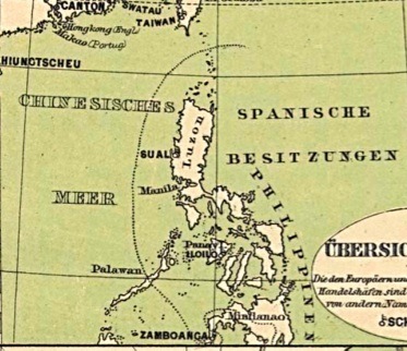
English: German map indicating the demarcation of Spanish-controlled territories vis-a-vis Moro dominated areas in the Philippine Islands, 1892 |
||
| 日期 | 10/30/08 | ||
| 来源 | 自己的作品 | ||
| 作者 | Jjarivera | ||
| 授权 (二次使用本文件) |
|
文件历史
点击某个日期/时间查看对应时刻的文件。
| 日期/时间 | 缩略图 | 大小 | 用户 | 备注 | |
|---|---|---|---|---|---|
| 当前 | 2008年10月29日 (三) 11:12 | | 373 × 322(61 KB) | Jjarivera~commonswiki(留言 | 贡献) | {{Information |Description={{en|1=German map indicating the demarcation of Spanish-controlled territories vis-a-vis Moro dominated areas in the Philippine Islands, 1892}} |Source=Own work by uploader |Author=Jjarivera |Date=10/30/08 |Pe |
您不可以覆盖此文件。
文件用途
没有页面使用本文件。
全域文件用途
以下其他wiki使用此文件:
- en.wikipedia.org上的用途
- zh.wikipedia.org上的用途