File:Spezia-marola-noarsenale.png
Jump to navigation
Jump to search

Size of this preview: 473 × 599 pixels. Other resolutions: 189 × 240 pixels | 495 × 627 pixels.
Original file (495 × 627 pixels, file size: 227 KB, MIME type: image/png)
Captions
Captions
Add a one-line explanation of what this file represents
Summary
[edit]
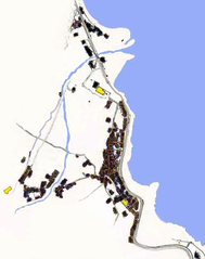
| Description |
Italiano: Mappa dei paesi di Marola e San Vito come dovevano apparire fino al 1860 circa. |
| Date | 03/02/2003 |
| Source | Own work |
| Author | F. Beverini |
Licensing
[edit]
| I, the copyright holder of this work, release this work into the public domain. This applies worldwide. In some countries this may not be legally possible; if so: I grant anyone the right to use this work for any purpose, without any conditions, unless such conditions are required by law. |
File history
Click on a date/time to view the file as it appeared at that time.
| Date/Time | Thumbnail | Dimensions | User | Comment | |
|---|---|---|---|---|---|
| current | 01:51, 15 August 2006 | | 495 × 627 (227 KB) | Pusk (talk | contribs) | == Dettagli == Description=Mappa dei paesi di Marola e San Vito come dovevano apparire fino al 1860 circa. Source= own work Date= 03/02/2003 Author= F. Beverini Permission= free other_versions= {{PD-Utente}} == Dettagli == Description=Mappa dei |
| 23:46, 14 August 2006 |  | 495 × 627 (213 KB) | Pusk (talk | contribs) | == Dettagli == {{Information |Description=Mappa dei paesi di Marola e San Vito come dovevano apparire fino al 1860 circa. |Source= own work |Date= 03/02/2003 |Author= F. Beverini |Permission= free |other_versions= }} |
You cannot overwrite this file.
File usage on Commons
There are no pages that use this file.
File usage on other wikis
The following other wikis use this file:
- Usage on it.wikipedia.org