File:Spezialkarte 4154 Ledeč und Wlaschim 600 dpi groß sw.jpg
Jump to navigation
Jump to search

Size of this preview: 758 × 600 pixels. Other resolutions: 303 × 240 pixels | 607 × 480 pixels | 971 × 768 pixels | 1,280 × 1,013 pixels | 2,560 × 2,026 pixels | 14,352 × 11,357 pixels.
Original file (14,352 × 11,357 pixels, file size: 60.65 MB, MIME type: image/jpeg)
Captions
Captions
Add a one-line explanation of what this file represents
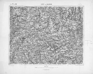
| Description | historische Landkarte: Spezialkarte 1:75.000, franzisco-josephinische (3.) Landesaufnahme der österreichisch-ungarischen Monarchie. Blatt Ledeč und Wlaschim Zone 7 Col. XII, später 4154 (mit dem Tal der Sazawa, Domaschin, Stepanow, Naceradec, Rothrecitz, Horepnik). 600 dpi große Dateiversion. |
| Date | nach Aufnahme 1878, Corr. 1892, Nachträge 1894 |
| Source | k.u.k. militär-geographisches Institut. |
| Author | Schrift und Gerippe F. Noltz, Terrainschraffierung von Feldwebel Alex Bendnarovski, k.u.k. militär-geographisches Institut, |
| Permission (Reusing this file) |
historisches amtliches Werk aus dem 19. Jahrhundert, freies Werk |
| Warning | The original file is very high-resolution. It might not load properly or could cause your browser to freeze when opened at full size. |
|---|
|
This work is in the public domain in its country of origin and other countries and areas where the copyright term is the author's life plus 70 years or fewer. | |
| This file has been identified as being free of known restrictions under copyright law, including all related and neighboring rights. | |
File history
Click on a date/time to view the file as it appeared at that time.
| Date/Time | Thumbnail | Dimensions | User | Comment | |
|---|---|---|---|---|---|
| current | 10:52, 27 March 2010 | | 14,352 × 11,357 (60.65 MB) | Josef Moser (talk | contribs) | {{Information |Description=historische Landkarte: Spezialkarte 1:75.000, franzisco-josephinische (3.) Landesaufnahme der österreichisch-ungarischen Monarchie. Blatt Ledeč und Wlaschim Zone 7 Col. XII, später 4154 (mit dem Tal der Sazawa, Domaschin, Ste |
You cannot overwrite this file.
File usage on Commons
There are no pages that use this file.