File:Spitalfields rookery.jpg
跳至導覽
跳至搜尋
無更高解析度可提供。
Spitalfields_rookery.jpg (800 × 417 像素,檔案大小:459 KB,MIME 類型:image/jpeg)
說明
說明
添加單行說明來描述出檔案所代表的內容
| 描述 |
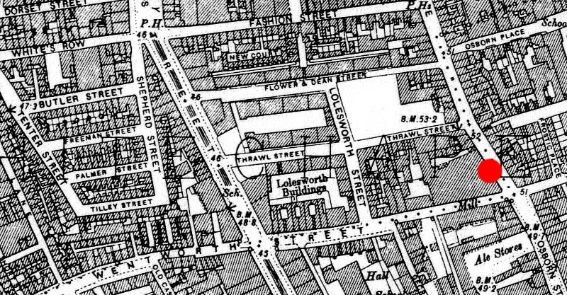
English: 1894 ordnance survey map of Whitechapel showing the area around en:Spitalfields where many common lodging-houses were situated in the late Victorian era. Red circle indicates the location at the junction of Osborn Street and en:Brick Lane near where en:Emma Elizabeth Smith (the first en:Whitechapel murders victim) was attacked. The building to the immediate west of the red circle is a chocolate factory. |
||||||
| 日期 | 1894, amended 2009 | ||||||
| 來源 | Original map downloaded from http://www.casebook.org/official_documents/map/images/ord_map_full.jpg | ||||||
| 作者 | Ordnance Survey, modified by uploader | ||||||
| 授權許可 (重用此檔案) |
|
||||||
| 其他版本 | Cropped from File:Whitechapel murders.jpg |

檔案歷史
點選日期/時間以檢視該時間的檔案版本。
| 日期/時間 | 縮圖 | 尺寸 | 使用者 | 備註 | |
|---|---|---|---|---|---|
| 目前 | 2009年12月4日 (五) 10:41 | | 800 × 417(459 KB) | DrKay(留言 | 貢獻) | {{Information |Description={{en|1=1894 ordnance survey map of Whitechapel showing the area around en:Spitalfields where many common lodging-houses were situated in the late Victorian era. Red circle indicates the location at the junction of Osborn St |
無法覆蓋此檔案。
檔案用途
沒有使用此檔案的頁面。
全域檔案使用狀況
以下其他 wiki 使用了這個檔案:
- da.wikipedia.org 的使用狀況
- en.wikipedia.org 的使用狀況
- es.wikipedia.org 的使用狀況
- fr.wikipedia.org 的使用狀況
- ja.wikipedia.org 的使用狀況
- ko.wikipedia.org 的使用狀況
- no.wikipedia.org 的使用狀況
- ru.wikipedia.org 的使用狀況
- zh.wikipedia.org 的使用狀況