File:Spokane County Plat Map (May 1893).jpg
Jump to navigation
Jump to search

Size of this preview: 394 × 600 pixels. Other resolutions: 157 × 240 pixels | 315 × 480 pixels | 504 × 768 pixels | 672 × 1,024 pixels | 1,345 × 2,048 pixels | 9,514 × 14,485 pixels.
Original file (9,514 × 14,485 pixels, file size: 32.42 MB, MIME type: image/jpeg)
Captions
Captions
Add a one-line explanation of what this file represents
Summary
[edit].jpg&action=edit§ion=1)
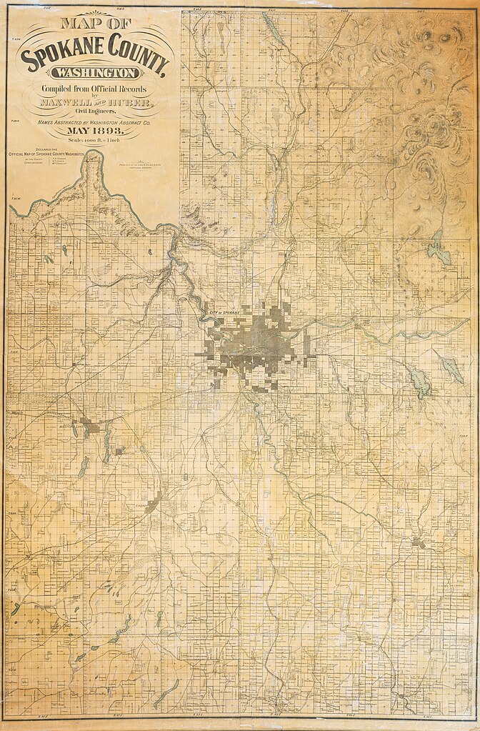
Official Map of Spokane County dated May 1893, produced by Maxwell and Huber, Civil Engineers. Scale of map is 1 inch is equal to 4,000 feet. Declared official by Spokane County Commissioners F.A. Fender, H.t. Jones and W.m Connelley. Map is a plat map, denoting property ownership and location names at the time.
Source: JPG from Spokane Public Library (archive URL: https://web.archive.org/web/20231211185713/https://lange.spokanelibrary.org/files/original/b01540e450cc0462e56b461e76926fd2.jpg)
Licensing
[edit].jpg&action=edit§ion=2)
This work is in the public domain in the United States because it was published (or registered with the U.S. Copyright Office) before January 1, 1929.
Public domain works must be out of copyright in both the United States and in the source country of the work in order to be hosted on the Commons. If the work is not a U.S. work, the file must have an additional copyright tag indicating the copyright status in the source country.
Note: This tag should not be used for sound recordings. |
File history
Click on a date/time to view the file as it appeared at that time.
| Date/Time | Thumbnail | Dimensions | User | Comment | |
|---|---|---|---|---|---|
| current | 19:07, 11 December 2023 | | 9,514 × 14,485 (32.42 MB) | Locke Cole (talk | contribs) | Official Map of Spokane County dated May 1893, produced by Maxwell and Huber, Civil Engineers. Scale of map is 1 inch is equal to 4,000 feet. Declared official by Spokane County Commissioners F.A. Fender, H.t. Jones and W.m Connelley. Map is a plat map, denoting property ownership and location names at the time. Source: [https://lange.spokanelibrary.org/files/original/b01540e450cc0462e56b461e76926fd2.jpg?fbclid=IwAR12Eyzy8v12R1BfkZ-RZXbi0-NmQXqPT4ZAkQGxSP60vKemceHhDahkBAs JPG] from Spokane P... |
You cannot overwrite this file.
File usage on Commons
There are no pages that use this file.
.jpg&oldid=865841889)