File:Spratly with flags.jpg
原始文件 (962 × 741像素,文件大小:94 KB,MIME类型:image/jpeg)
说明
说明

|
此locator map图片可使用矢量图形重新创建为SVG文件。这具有很多好处;更多信息请参见共享资源:待清理媒体。如果存在此图片的SVG格式,请将其上传,然后将此模板替换为
{{vector version available|新图片名称}}。
建议您将SVG命名为“Spratly with flags.svg”,这样在使用Vector version available(或Vva)模板时就不需要填写新图片名称参数。 |


| 描述 |
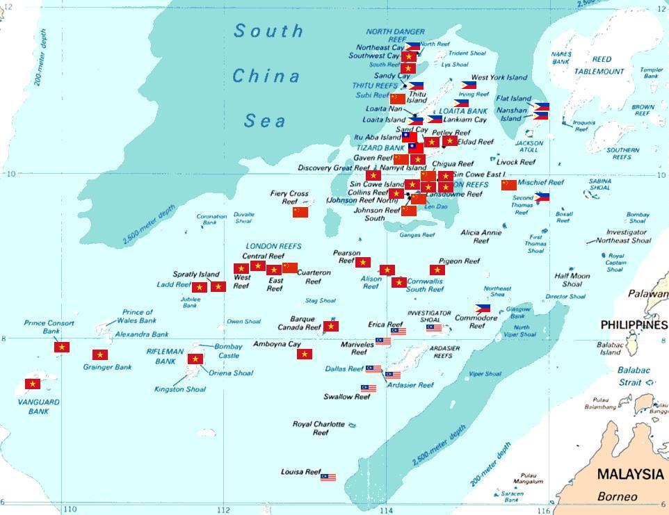
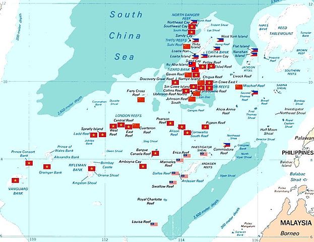
Spratly islands map showing occupied features marked with the flags of countries occupying them.
Kennan Reef (C) The flag nearest the flag for Johnson South Reef (C). |
||||||
| 日期 | (Original Picture), February 3, 2008 (Modified Picture) | ||||||
| 来源 | Central Intelligence Agency. | ||||||
| 作者 | CIA. Cropped and Flags added by Estarapapax. | ||||||
| 授权 (二次使用本文件) |
|
||||||

文件历史
点击某个日期/时间查看对应时刻的文件。
| 日期/时间 | 缩略图 | 大小 | 用户 | 备注 | |
|---|---|---|---|---|---|
| 当前 | 2008年3月25日 (二) 05:38 | | 962 × 741(94 KB) | KAVO(留言 | 贡献) | {{Information |Description=Spratly islands map showing occupied features marked with the flags of countries occupying them. <br>{{flagicon|Philippines}} Philippines <br>{{flagicon|Taiwan}} Taiwan <br>{{flagicon|Vietnam}} Vietnam <br>{{flagicon|Malaysia}} |
您不可以覆盖此文件。
文件用途
以下4个页面使用本文件:
全域文件用途
以下其他wiki使用此文件:
- az.wikipedia.org上的用途
- bg.wikipedia.org上的用途
- ceb.wikipedia.org上的用途
- cs.wikipedia.org上的用途
- da.wikipedia.org上的用途
- de.wikipedia.org上的用途
- en.wikipedia.org上的用途
- es.wikipedia.org上的用途
- et.wikipedia.org上的用途
- fr.wikipedia.org上的用途
- hi.wikipedia.org上的用途
- id.wikipedia.org上的用途
- ja.wikipedia.org上的用途
查看此文件的更多全域用途。