File:St-laurent-labbaye--st-quentin--sully--tracy--menetreol--cassini.png
Jump to navigation
Jump to search

Size of this preview: 800 × 374 pixels. Other resolutions: 320 × 149 pixels | 640 × 299 pixels | 1,203 × 562 pixels.
Original file (1,203 × 562 pixels, file size: 1.63 MB, MIME type: image/png)
Captions
Captions
Add a one-line explanation of what this file represents
Summary
[edit]
| Description |
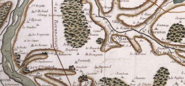
English: 18th century Cassini map of France, detail, in the present Nièvre departement, Burgundy. Centered on Saint-Laurent abbey (fr) located here just beside Saint-Martin-du-Tronsec, some 6 mi (~10 km) S-E of Cosne-sur-Loire (just beyond the upper left corner of the picture). The Loire river runs near the left margin of the map, south-north direction, so we are mainly looking at the right bank of the river. The "road (from Paris) to Lyon through the Bourbonnais" is in between the abbey and the port, about 3 mi (4,6 km) away. Other towns and villages: Saint-Quentin (Saint-Quentin-sur-Nohain) and Suilly-la-Tour (East), Saint-Andelain (South), Tracy (S-W) and part of the name of Ménétréol (Ménétréol-sous-Sancerre) facing Tracy on the left bank of the Loire. Tracy, small port on the Loire river, is some 4.4 mi (7 km) west to the abbey.
Français : Carte de Cassini (XVIIIe s.), détail, dans le nord-est du département de la Nièvre, en Bourgogne. Carte centrée sur l'abbaye Saint-Laurent-les-Cosne à Saint-Laurent-l'Abbaye, juste à côté de Saint-Martin-du-Tronsec, à ~10 km au sud-est de Cosne-sur-Loire. Le nom de "St Laurent" est suivi des lettres "A.H.O.A.", pour "Abbaye d'Hommes Ordre Augustin" (voir ici). La Loire, coulant du sud au nord, est indiquée sur le côté gauche (ouest) de la carte - cette dernière couvrant donc essentiellement la rive droite du fleuve. Autres villages : Saint-Quentin (Saint-Quentin-sur-Nohain) et Suilly-la-Tour (à l'est), Saint-Andelain (sud), Tracy (S-O) et une partie du nom de Ménétréol face à Tracy en rive gauche de la Loire (dans le coin en bas à gauche de l'image). Tracy, petit port sur la Loire, est à 7 km à l'ouest. La "route de (Paris à) Lyon par le Bourbonnais" traverse la carte du nord au sud et passe à 4,5 km à l'est de l'abbaye. |
| Date | |
| Source | geoportail.gouv.fr |
| Author | Cassini family |
| Camera location | | View this and other nearby images on: OpenStreetMap |
|---|
Licensing
[edit]
|
This work is in the public domain in its country of origin and other countries and areas where the copyright term is the author's life plus 70 years or fewer. This work is in the public domain in the United States because it was published (or registered with the U.S. Copyright Office) before January 1, 1929. | |
| This file has been identified as being free of known restrictions under copyright law, including all related and neighboring rights. | |
File history
Click on a date/time to view the file as it appeared at that time.
| Date/Time | Thumbnail | Dimensions | User | Comment | |
|---|---|---|---|---|---|
| current | 21:11, 21 February 2017 | | 1,203 × 562 (1.63 MB) | Pueblo89 (talk | contribs) | User created page with UploadWizard |
You cannot overwrite this file.
File usage on Commons
The following page uses this file:
File usage on other wikis
The following other wikis use this file:
- Usage on de.wikipedia.org
- Usage on fr.wikipedia.org