File:St. Johns, Arizona (101310387).jpg

Rozmiar pierwotny (1600 × 1200 pikseli, rozmiar pliku: 610 KB, typ MIME: image/jpeg)
Podpisy
Podpisy
Opis[edytuj]
.jpg&action=edit§ion=1)
| Opis |
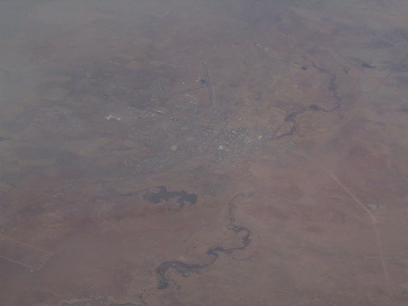
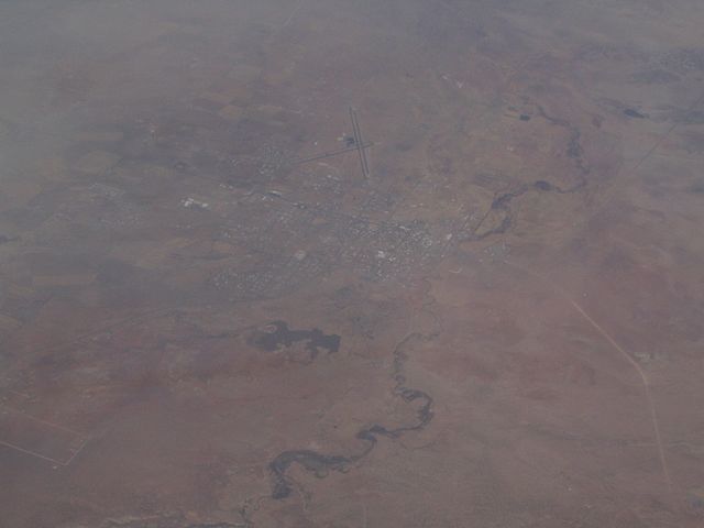
St. Johns is the only city in and the county seat of Apache County, Arizona, United States. It is located along U.S. Route 180, mostly west of where that highway intersects with U.S. Route 191. According to 2006 Census Bureau estimates, the population of the city was 3,538. St. Johns was first settled in 1873 by the Barth Brothers. They were bought out in 1879 by Ammon M. Tenney. St. Johns has been the county seat for almost all of the county's history. When the county was created on February 24, 1879, Snowflake was designated the county seat. After the first election in fall 1879, county government was set up in St. Johns, though it was moved again in 1880, to Springerville; in 1882 St. Johns again became the county seat, and it has remained so ever since. St. Johns is home to the Apache County Historical Society Museum and has four National Register of Historic Places: Isaacson Building, Lower Zuni River Archeological District, Lyman Lake Rock Art Site, and Rattlesnake Point Pueblo. St. Johns is near the Placerias Quarry, the site where dozens of Placerias fossils were discovered in 1930 by Charles Camp and Samuel Welles, of the University of California, Berkeley. St. Johns is along the shortest and most scenic route from Phoenix to Albuquerque, New Mexico. Within an hour's drive from St. John's are Apache-Sitgreaves National Forest, Petrified Forest National Park, the Painted Desert, and Lyman Lake State Park, as well as Indian reservations such as the Navajo Nation, Fort Apache Indian Reservation, San Carlos Apache Indian Reservation, and Zuni Indian Reservation. en.wikipedia.org/wiki/St._Johns,_Arizona en.wikipedia.org/wiki/Wikipedia:Text_of_Creative_Commons_... |
| Data | |
| Źródło | St. Johns, Arizona |
| Autor | Ken Lund from Reno, Nevada, USA |
| Pozycja fotografa | | To i inne zdjęcia na: OpenStreetMap |
|---|
.jpg¶ms=034.506910_N_-109.361858_E_globe:Earth_type:camera_source:Flickr_&language=pl)
Licencja[edytuj]
.jpg&action=edit§ion=2)
- Wolno:
- dzielić się – kopiować, rozpowszechniać, odtwarzać i wykonywać utwór
- modyfikować – tworzyć utwory zależne
- Na następujących warunkach:
- uznanie autorstwa – musisz określić autorstwo utworu, podać link do licencji, a także wskazać czy utwór został zmieniony. Możesz to zrobić w każdy rozsądny sposób, o ile nie będzie to sugerować, że licencjodawca popiera Ciebie lub Twoje użycie utworu.
- na tych samych warunkach – Jeśli zmienia się lub przekształca niniejszy utwór, lub tworzy inny na jego podstawie, można rozpowszechniać powstały w ten sposób nowy utwór tylko na podstawie tej samej lub podobnej licencji.
| Ten plik, opublikowany pierwotnie w serwisie Flickr przez Ken Lund pod adresem https://flickr.com/photos/75683070@N00/101310387, został sprawdzony 3 grudnia 2015 przez FlickreviewR, który potwierdził, że jest on tam dostępny na licencji cc-by-sa-2.0. |
Historia pliku
Kliknij na odpowiedniej dacie/czasie, aby zobaczyć wersję pliku z tamtego okresu.
| Data/czas | Miniatura | Wymiary | Użytkownik | Opis | |
|---|---|---|---|---|---|
| aktualny | 21:43, 3 gru 2015 | | 1600 × 1200 (610 KB) | INeverCry (dyskusja | edycje) | Transferred from Flickr via Flickr2Commons |
Nie możesz nadpisać tego pliku.
Lokalne wykorzystanie pliku
Następujące strony korzystają z tego pliku:
Globalne wykorzystanie pliku
Ten plik jest wykorzystywany także w innych projektach wiki:
- Wykorzystanie na ar.wikipedia.org
- Wykorzystanie na arz.wikipedia.org
- Wykorzystanie na bg.wikipedia.org
- Wykorzystanie na ca.wikipedia.org
- Wykorzystanie na ceb.wikipedia.org
- Wykorzystanie na ce.wikipedia.org
- Wykorzystanie na cy.wikipedia.org
- Wykorzystanie na es.wikipedia.org
- Wykorzystanie na eu.wikipedia.org
- Wykorzystanie na he.wikipedia.org
- Wykorzystanie na ht.wikipedia.org
- Wykorzystanie na hu.wikipedia.org
- Wykorzystanie na it.wikipedia.org
- Wykorzystanie na lld.wikipedia.org
- Wykorzystanie na no.wikipedia.org
- Wykorzystanie na pl.wikipedia.org
- Wykorzystanie na pt.wikipedia.org
- Wykorzystanie na ro.wikipedia.org
- Wykorzystanie na sr.wikipedia.org
- Wykorzystanie na tt.wikipedia.org
- Wykorzystanie na uz.wikipedia.org
- Wykorzystanie na vo.wikipedia.org
- Wykorzystanie na www.wikidata.org
.jpg&oldid=675164751)