File:St. Luke's AME Zion Church - fmr Central Church of Christ - Buffalo, New York - 20200623.jpg
Jump to navigation
Jump to search
Size of this preview: 799 × 599 pixels. Other resolutions: 320 × 240 pixels | 640 × 480 pixels | 1,024 × 768 pixels | 1,280 × 960 pixels | 2,560 × 1,920 pixels | 3,205 × 2,404 pixels.
Original file (3,205 × 2,404 pixels, file size: 2.51 MB, MIME type: image/jpeg)
Captions
Captions
Add a one-line explanation of what this file represents
Summary[edit]
| Description |
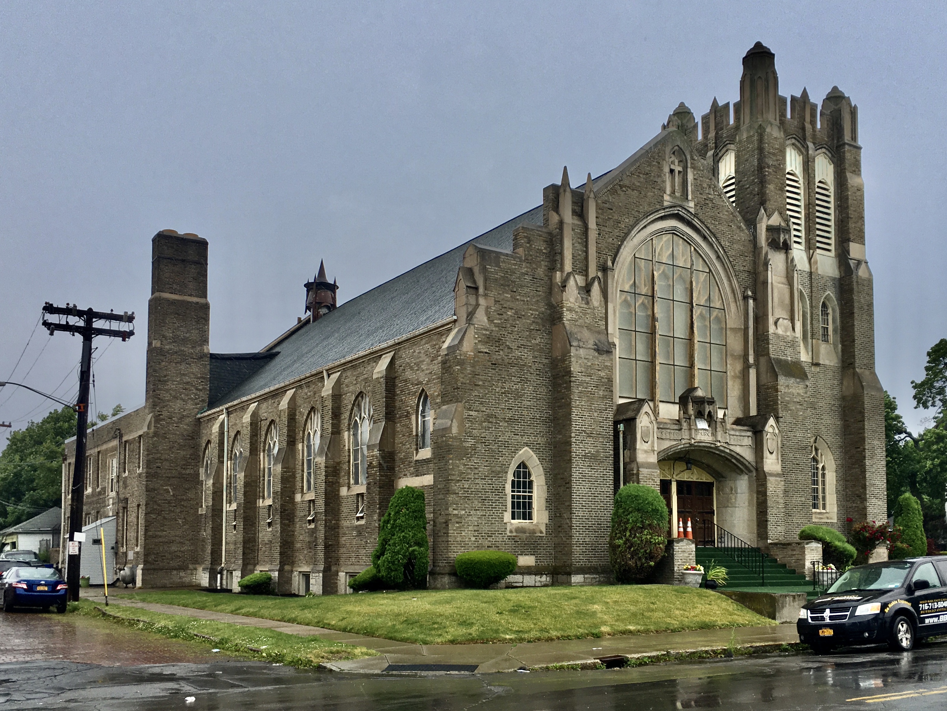
English: St. Luke's African Methodist Episcopal Zion Church, 314 East Ferry Street at Lonsdale Road, Buffalo, New York, June 2020. Designed in an English Gothic style by architect Frank Spangenberg, the building's design is at first blush typical of ecclesiastical architecture of the day (the segmental-arched entrance and side buttresses are, if anything, unusually simplified for a building of such ample dimensions, and the large front window with bar tracery is a textbook feature of the style), but creative touches begin to make themselves apparent before too long: the steepleless tower on the east side of the building sports pinnacled crenellation, for instance. The building originally served as the second and final home of the Central Church of Christ, a congregation that traces its history back to 1888, when the Richmond Avenue Church of Christ, which was famous for its zeal in establishing mission churches to minister to other areas of the city, founded one in the Masten Park neighborhood. Known initially as the Jefferson Avenue Church of Christ, the congregation moved to the newly established Hamlin Park neighborhood in 1923 and took on their new name at that time to better reflect their geographic location within the city. In 1957, the building became home to St. Luke's AME Zion Church, a church with deep roots in Buffalo's African-American community, dating back to a 1901 schism among the members of Bethel AME Church springing from a dispute over the question of whether to relocate; ironically, St. Luke's decision to relocate to Hamlin Park from their former location on the Near East Side led to another schism. |
| Date | |
| Source | Own work |
| Author | Andre Carrotflower |
| Camera location | | View this and other nearby images on: OpenStreetMap |
|---|
Licensing[edit]
I, the copyright holder of this work, hereby publish it under the following license:
This file is licensed under the Creative Commons Attribution-Share Alike 4.0 International license.
- You are free:
- to share – to copy, distribute and transmit the work
- to remix – to adapt the work
- Under the following conditions:
- attribution – You must give appropriate credit, provide a link to the license, and indicate if changes were made. You may do so in any reasonable manner, but not in any way that suggests the licensor endorses you or your use.
- share alike – If you remix, transform, or build upon the material, you must distribute your contributions under the same or compatible license as the original.
File history
Click on a date/time to view the file as it appeared at that time.
| Date/Time | Thumbnail | Dimensions | User | Comment | |
|---|---|---|---|---|---|
| current | 21:21, 5 July 2020 | | 3,205 × 2,404 (2.51 MB) | Andre Carrotflower (talk | contribs) | Uploaded own work with UploadWizard |
You cannot overwrite this file.
File usage on Commons
The following page uses this file:
Metadata
Categories:
- June 2020 in Buffalo
- Churches in the United States photographed in 2020
- Churches in New York (state) built in 1923
- Built in Buffalo, New York in 1923
- 1920s churches in Buffalo, New York
- Brick churches in Buffalo, New York
- African Methodist Episcopal Zion churches in New York
- Gothic Revival churches in Buffalo, New York
- Methodist churches in Buffalo, New York
- East Ferry Street (Buffalo, New York)
- Hamlin Park Historic District
- Former Christian Church (Disciples of Christ) churches in Buffalo, New York