File:St Catherine's Lighthouse - geograph.org.uk - 1414472.jpg
Aller à la navigation
Aller à la recherche
Taille de cet aperçu : 450 × 600 pixels. Autres résolutions : 180 × 240 pixels | 480 × 640 pixels.
Fichier d’origine (480 × 640 pixels, taille du fichier : 40 kio, type MIME : image/jpeg)
Légendes
Légendes
Ajoutez en une ligne la description de ce que représente ce fichier
Description
[modifier]
| Description |
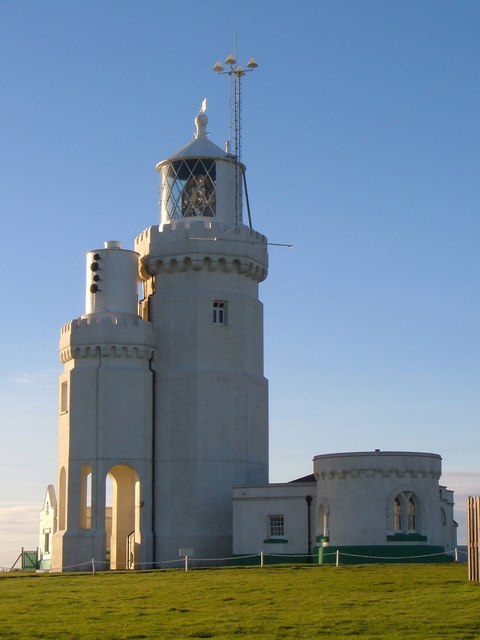
English: St Catherine's Lighthouse Like most lighthouses, it's an attractive structure, also shown at https://www.geograph.org.uk/gridref/SZ4975?class=Lighthouse&nl=1 . "Built 1838-40. Designed by Walker and Burgess and altered in 1875 when, on account of mist the height was reduced to 86 feet by the removal of the upper stage and part of the middle stage. Stuccoed octagonal tower of 2 stages. Machicolations and castellated parapet surmounted by conical light and ball finial and weathervane. In 1932 a lower tower of 2 storeys, reproducing the design of the main lighthouse as shortened, but with an open arcade on the ground floor, was added on the south side to mount the foghorn. These 2 towers are known locally as the Cow and the Calf. To the west of the main Lighthouse tower is a doorway with the date 1838 over it and a projection on the ground floor with gable above {this can be seen on the left}. Attached to the east is the Head Lighthouse keeper's house of 1 storey with curved front and round headed window facing east. This lighthouse was one of the first in the world to be illuminated by electric light being fitted with it in 1888 ... St Catherine's lighthouse was built as a result of the wreck of the 'Clarendon' in Chale Bay on the 11th October 1836. " http://www.imagesofengland.org.uk/details/default.aspx?id=392863 |
| Date | |
| Source | From geograph.org.uk |
| Auteur | Derek Harper |
| Attribution (imposé par la licence) | Derek Harper / St Catherine's Lighthouse / |
| Lieu de la prise de vue | | Voir cet endroit et d’autres images sur : OpenStreetMap |
|---|
_heading:270.00&language=fr)
| Position de l'objet | | Voir cet endroit et d’autres images sur : OpenStreetMap |
|---|
_heading:270.00&language=fr)
Conditions d’utilisation
[modifier]

|
Cette image provient de la collection du projet Geograph British Isles. Pour obtenir les coordonnées du photographe, veuillez consulter cette page de description de l'image sur le site du projet. Les droits d'auteurs sur cette image sont détenus par Derek Harper ; l'image est placée sous une licence Creative Commons avec mention de paternité et partage à l'identique (CC-By-SA) en version 2.0.
|
Ce fichier est disponible selon les termes de la licence Creative Commons Attribution – Partage dans les Mêmes Conditions 2.0 Générique
Attribution: Derek Harper
- Vous êtes libre :
- de partager – de copier, distribuer et transmettre cette œuvre
- d’adapter – de modifier cette œuvre
- Sous les conditions suivantes :
- paternité – Vous devez donner les informations appropriées concernant l'auteur, fournir un lien vers la licence et indiquer si des modifications ont été faites. Vous pouvez faire cela par tout moyen raisonnable, mais en aucune façon suggérant que l’auteur vous soutient ou approuve l’utilisation que vous en faites.
- partage à l’identique – Si vous modifiez, transformez, ou vous basez sur cette œuvre, vous devez distribuer votre contribution sous la même licence ou une licence compatible avec celle de l’original.
Historique du fichier
Cliquer sur une date et heure pour voir le fichier tel qu'il était à ce moment-là.
| Date et heure | Vignette | Dimensions | Utilisateur | Commentaire | |
|---|---|---|---|---|---|
| actuel | 1 mars 2011 à 17:01 | | 480 × 640 (40 kio) | GeographBot (d | contributions) | == {{int:filedesc}} == {{Information |description={{en|1=St Catherine's Lighthouse Like most lighthouses, it's an attractive structure, also shown at http://www.geograph.org.uk/gridref/SZ4975?class=Lighthouse&nl=1 . "Built 1838-40. Designed by Walker and |
Vous ne pouvez pas remplacer ce fichier.
Utilisations locales du fichier
Aucune page n’utilise ce fichier.
Utilisations du fichier sur d’autres wikis
Les autres wikis suivants utilisent ce fichier :
- Utilisation sur fr.wikipedia.org
- Utilisation sur nl.wikipedia.org